
Take a scenic drive on Arizona’s Back Country Byways
Whether you're planning a short weekend getaway or a cross-country expedition, Back Country Byways offer unforgettable experiences by car across America’s public lands, especially as the nation approaches its 250th anniversary.
The Bureau of Land Management (BLM) manages 54 Back Country Byways spanning nearly 3,000 miles in the United States. These range from Type I to Type IV routes, meaning that the type of vehicle they are best for might vary.
In Arizona, the BLM has four Back Country Byways for you to enjoy for free. These are a portal to adventures off the beaten path.
- Black Hills Back Country Byway
- Harquahala Mountain Back Country Byway
- Route 66 Historic Back Country Byway
- Parker Dam Road Back Country Byway
The BLM’s Back Country Byways program works with local communities and other partners to keep these areas open for everyone. It also helps support small towns and businesses by encouraging local tourism.
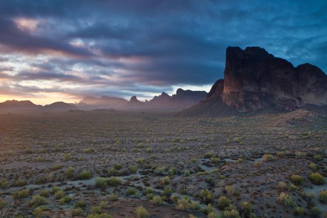
Aside from awesome public lands, these byways offer you the chance to experience the communities they connect. For example, stop by Oatman along the Route 66 Historic Back Country Byway to see the iconic wild burros and experience the Wild West. Did you know the real London Bridge made its way to Lake Havasu City in the 1960s? After cruising the Parker Dam Road Back Country Byway, continue on to Lake Havasu City to see the historic bridge. There is so much to explore along and between these byways, including Harquahala Mountain near Wickenburg and Black Hills near Safford and Clifton.
Along the byways, you can enjoy fun activities like:
- Camping
- Swimming
- Boating
- Fishing
- Rockhounding
- Hiking
- Off-road driving
- Wildlife watching
Before you explore the BLM’s Back Country Byways, many of which travel through remote areas with limited services, remember these tips:
- Check weather and road conditions ahead of time
- Bring area-specific maps and route descriptions
- Carry plenty of water
- Bring adequate fuel
- Carry a spare tire, jack, tools, shovel, blanket, etc.
- Remember that signing and fencing are for your safety
- Tread Lightly on the land
Once you’ve prepared, buckle up and set out on the open road.
Black Hills Back Country Byway
- Length: 21 miles (33.8 kilometers)
- Speed limit: Obey all posted signs and traffic laws
- Road terrain/surface: Not regularly maintained, gravel and loose rock
- Vehicle requirements: A high-clearance vehicle is recommended
- Nearest town: Safford and Clifton
- Nearby recreation opportunities: Canyon Overlook Picnic Area, Owl Creek Campground, Black Hills Rockhound Area, Gila Box Riparian National Conservation Area
Imagine the early pioneers who once traveled this rugged road. In the past, it covered nearly 40 miles between Greenlee and Graham counties. Black Hills Back Country Byway is located between Safford and Clifton in southeastern Arizona, about three hours northeast of Tucson or 3.5 hours east of Phoenix.
Today, you can experience the spirit of the Old West while angling for largemouth bass along the Gila River, enjoy a picnic, rockhounding for fire agate, or exploring a primitive side road. Both ends of the byway are accessed from U.S. Highway 191. The southern end is at milepost 139, the northern end at milepost 160.
Along the way, stop at Canyon Overlook Picnic Area, located about 7 miles from the southern end and 14 from the northern end. It provides a scenic vista of the Gila River canyon and nearby mountain ranges.
The Black Hills Rockhound Area makes a great day adventure for rock collectors, especially those looking for fire agate. The site is open for casual use rockhounding within a reasonable limit by the public without fees or permits. Rockhounding is for personal use, and specimens should not be collected for sale, barter or any commercial purpose. Before your visit, learn more about rockhounding in Arizona.
Have questions while planning your visit? Contact the Safford Field Office.
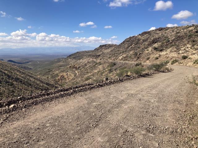
Harquahala Mountain Back Country Byway
- Length: 10.5 miles (16.9 kilometers)
- Speed limit: While there is no official speed limit, please be safe and mindful of other visitors — obey all posted signs and traffic laws
- Road terrain/surface: Not regularly maintained, gravel and loose rock
- Vehicle requirements: A four-wheel drive high clearance vehicle is recommended
- Nearest town: Wickenburg
- Nearby recreation opportunities: Harquahala Mountains Wilderness, Harquahala Peak Observatory, Harquahala Pack Trail Basecamp Trailhead
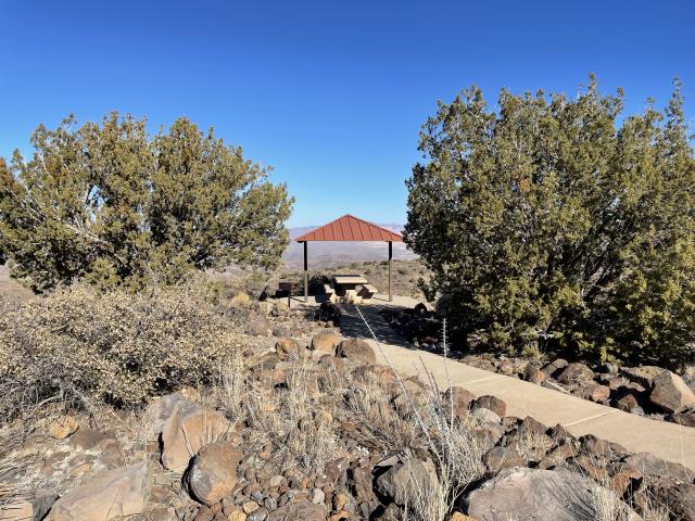
Before heading up Harquahala Mountain along the Back Country Byway, visitors can stop at a semi-primitive staging area. Here you'll find a ramada with interpretive panels that share the region’s rich history and natural features. The staging area also includes a vault toilet, two campsites with picnic tables and fire pits, and a convenient loading ramp for off-highway vehicles.
Along the byway, visitors journey into Arizona’s mining past. For over a century, the area drew prospectors in search of gold, silver, and copper. Small-scale mining operations once dotted the landscape, leaving behind a patchwork of abandoned sites. Old mining debris, shafts and stone houses from earlier miners can be seen from the byway.
On public lands, remember to always keep a safe distance from mine shafts and tunnels and leave any artifacts undisturbed. Unstable ground around shafts may collapse without warning, and tunnels may cave in or contain toxic air. Protect yourself and others: Stay Out, Stay Alive!
The byway climbs steadily toward the summit of Harquahala Mountain, rising to an impressive 5,600 feet. At the top, visitors are rewarded with panoramic views of the surrounding mountain ranges, including the nearby Eagletail Mountains. Look out for the iconic Courthouse Rock, which is over 2,800 feet tall.
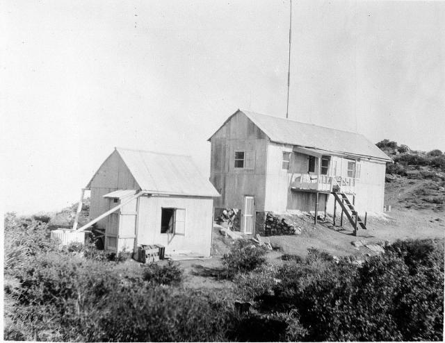
Another highlight is at the top: the Harquahala Peak Observatory. In the 1920s, it was built by the Smithsonian Institution to observe solar activity. How the scientists lived and worked there tells a story of resilience, ingenuity, and the spirit of American scientific ambition. Today, the Harquahala Peak Observatory is on the National Register of Historic Places.
The nearby public lands and communities also have more for you to explore. The town of Wickenburg, which is about 60 miles northwest of Phoenix, was named after Prussian immigrant Henry Wickenburg who struck gold in the desert near the Hassayampa River. Learn more about the town’s history at the Wickenburg Chamber of Commerce’s family-friendly visitor center or come around Gold Rush Days in February.
Have questions while planning your visit? Contact the Hassayampa Field Office.
Route 66 Historic Back Country Byway
- Length: 42 miles (67.6 kilometers)
- Speed limit: Signs posted along the byway range from 20 to 45 miles per hour, obey all posted signs and traffic laws
- Road terrain/surface: Paved asphalt
- Vehicle requirements: Any road-worthy vehicle, automatic transmission recommended due to steep grades
- Nearest town: Kingman, Oatman, and Topock/Golden Shores
- Nearby recreation opportunities: Mount Nutt Wilderness, Warm Springs Wilderness, Mohave & Milltown Railroad Trails, Cerbat Foothills Recreation Area, Historic Route 66 California Gateway Site Day Use Area
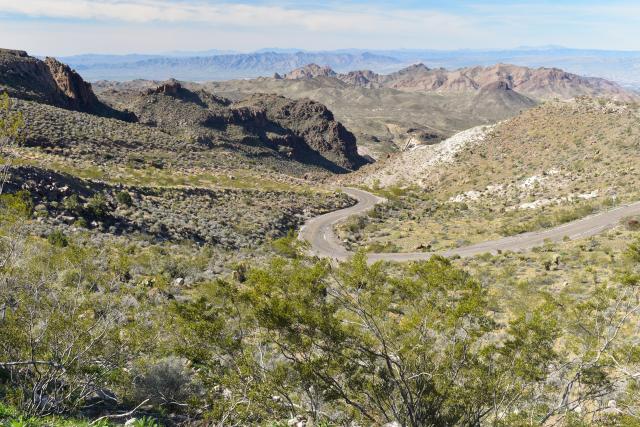
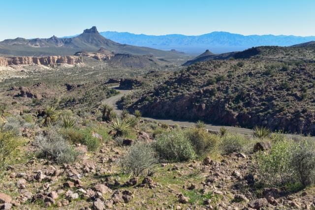
Tucked away in western Arizona, the Route 66 Historic Back Country Byway provides visitors with the opportunity to explore a section of America’s first transcontinental highway.
Back in the 1930s, this portion of Route 66 in Arizona posed a challenge for travelers. The infamous Sitgreaves Pass, with its hairpin turns and steep grades, tested the nerves of early motorists as they climbed through the Black Mountains. The pass was named after Captain Lorenzo Sitgreaves, of the Corps of Topographical Engineers, who led the 1851 Expedition Down the Zuni and Colorado Rivers.
Today, those same curves and climbs offer a thrilling ride that defined the golden age of American travel. When Route 66 was officially decommissioned in 1985, it marked the end of an era, but not the end of the road’s story.
Nearby towns and public lands also offer much to check out. After all, Route 66 was once known as the “Main Street of America.” Towns like Kingman and Oatman offer the opportunity to explore and learn about the region’s eras at museums, motels, diners and more. Along the byway, mileposts 15, 17.1, 33.8 and 34.7 all provide access to the Warm Springs Wilderness, which offers offer outstanding opportunities for primitive recreation like dispersed camping, hiking, and horseback riding. Four-wheel drive is required for all access routes to the wilderness.
Get your kicks! Have questions while planning your visit? Contact the Kingman Field Office.
Parker Dam Road Back Country Byway
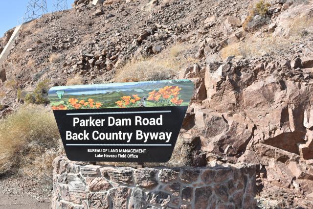
- Length: 11 miles (17.7 kilometers)
- Speed limit: Signs posted along the byway range from 15 to 55 miles per hour, obey all posted signs and traffic laws
- Road terrain/surface: Paved asphalt
- Vehicle requirements: Oversized vehicles and vehicles towing trailers are not allowed to cross the Parker Dam
- Nearest town: Lake Havasu City and Earp (California)
- Nearby recreation opportunities: Take Off Point Recreation Area, Crossroads Campground, Rock House Recreation Area and Visitor Center
- Additional information: There are video and drone restrictions near the dam — follow all posted signs
The adventure begins in Arizona at the iconic Parker Dam. Often referred to as the "deepest dam in the world," Parker Dam is a concrete arch structure built by the U.S. Bureau of Reclamation in the 1930s, anchoring the northern end of the Parker Strip. Its construction once sparked fierce controversy, especially from then-Arizona Governor Benjamin Moeur.
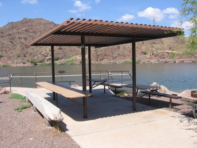
Before you cross the dam, consider stopping at Take Off Point. It includes parking and wheelchair-accessible boat docks, fishing piers, picnic tables, ADA-compliant vault toilet, and a fish-cleaning station. Leashed service animals and pets are welcome at Take Off Point. Boaters can also access any of the 73 boat-in campsites along the Arizona shoreline of Lake Havasu from Take Off Point.
Crossing over into California, the byway continues along Parker Dam Road south to the boundary of the Colorado River Indian Reservation.
You can follow the Parker Dam Road Scenic Back Country Byway to a few recreation sites along the lower Colorado River. Stop to enjoy some fun at the Parker Strip Recreation Area, including Copper Basin Dunes OHV Area, Crossroads Campground and more. Popular activities in the Parker Strip Recreation Area include hiking, biking, rock
Stop by Rock House Visitor Center in the winter to be greeted by volunteer site host Maureen’s awesome artwork and interactive activities. Year-round, you can enjoy river access, a boat launch, shaded benches, and restrooms near the visitor center.
Have questions while planning your visit? Contact the Lake Havasu Field Office.
Related Content
Related Stories
- Freedom and Liberty Bring the Spirit of the West to Northern Virginia
- BLM-authorized rights of way on public lands connect Arizona’s economy, communities
- Sharing the Spirit of America: A Celebration on the Snake River Canyon Rim
- BLM, Partners Enhance Public Access at Popular Recreation Area
- Birding Aravaipa Canyon: A morning of songs, color, and creekside adventure
Office
One North Central Ave., Suite 800
Phoenix, AZ 85004-4427
United States