
Armchair Adventures
America’s public lands offer some of the most spectacular and interesting places you’ll ever see. While everyone is encouraged to stay at home, the BLM Blog will feature "Armchair Adventures." This is your opportunity to travel virtually and learn a bit about these amazing places. Today, follow along with the third installment of Armchair Adventures.
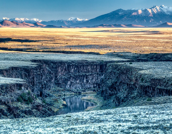
Rio Grande River, Taos Box, New Mexico
Vistas from the basalt plateaus above the Rio Grande Gorge are dramatic and expansive. This view to the north takes in Colorado’s San Luis Valley and the Sangre de Cristo Range with Blanca Peak in the distance. It’s not hard to imagine that powerful geological process worked to create this diverse array of landforms. The approximately 50-mile gorge runs through basalt flows of the Taos Plateau volcanic field and increases in depth to over 800 feet at its deepest point northwest of Taos. The river flows through the low point of a major break in the Earth’s crust – the Rio Grande rift –which starts in the central Colorado Rockies and runs southward through New Mexico into the Mexican State of Chihuahua. The rift is formed where a section of the Earth’s crust arched, weakened, and spread apart due to heat from basaltic magma welling up from the mantle 29 million years ago.
The outstanding values along this segment of the Rio Grande led it to be recognized as one of the first eight rivers designated as Wild and Scenic in 1968. The challenging rapids of the Taos Box are framed by steep basalt cliffs. Ledges and overhangs provide outstanding habitat for nesting eagles, hawks and falcons and security from predators for rocky mountain bighorn sheep. The Bureau of Land Management – New Mexico’s Taos Field Office manages this segment of the Rio Grande.
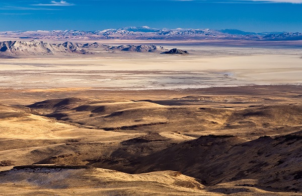
Black Rock Playa, Nevada
Looking down on the Black Rock Playa from the Calico Mountains, it’s hard to imagine how emigrants on their way to California in the 1850s felt upon reaching the driest most desolate part of the trail. Black Rock Point, visible in the center of the photo, was a major point of reference for the emigrants. Their journals include descriptions of discarded gear and dead oxen along the way and boiling hot springs, but no drinking water.
The playa is formed from silt that settled out of Ice Age Lake Lahontan, which reached 500 feet in depth – old lake terraces still ring the mountains around the playa. Now the playa is dry except when winter rains and snowmelt temporarily create a shallow pool of water. Fairy shrimp hatch and reproduce during these short wet periods and their eggs lie dormant in the playa silt for many months or years until the right conditions emerge.
One-hundred and seventy years after emigrants made their difficult trek across the playa, the area remains remote and undeveloped. However, the Black Rock also attracts a curious array of events and uses. Most notably, the Burning Man gathering is held annually at the southern end of the playa attracting 80,000 participants who set up a temporary city each August. The vast playa is a perfect launch location, and annually hosts armature rocket events. In 2004, a launch from the playa climbed 72 miles above the earth making it the first armature rocket to reach space. In 1997, Thrust SSC driven by Andy Green became the world's first, and so far, the only supersonic car, reaching 763.035 mph on the tabletop flat surface of the playa. The Black Rock-High Rock-Emigrant Trails National Conservation Area is managed by the Bureau of Land Management’s Nevada Winnemucca District.
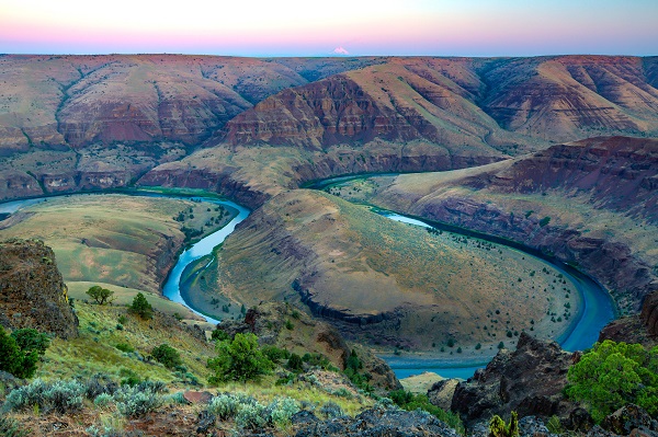
John Day River, Oregon
The John Day River is a tributary of the Columbia River, approximately 284 miles (457 km) long, in northeastern Oregon in the United States and managed by the BLM Oregon. Undammed along its entire length, the river is the third longest free-flowing river in the contiguous United States. There is extensive use of its waters for irrigation. Its course furnishes habitat for diverse species, including wild steelhead and Chinook salmon runs. However, the steelhead populations are under federal Endangered Species Act (ESA) protections, and the Chinook salmon have been proposed for such protection.
The river was named for John Day, a member of the Pacific Fur Company's overland expedition to the mouth of the Columbia River that left Missouri in 1810. Day struggled through eastern Oregon during the winter of 1811–12. While descending the Columbia River in April 1812, he and Ramsay Crooks were robbed by Native Americans at the mouth of the river that now bears his name, forcing them to hike 80 miles (130 km) back to friendly Umatilla Indians under extreme conditions.
The absence of dams on the river causes its flow to greatly fluctuate throughout the year depending on snowpack and rainfall within the watershed. The highest flow recorded at a gauge on the lower John Day was 43,300 cubic feet per second (1,230 m3/s) on January 2, 1997. The lowest flow was no flow at all, which occurred on September 2, 1966; from August 15 to September 16, 1973; and on nine days in August 1977. The average flow at the gauge is 2,075 cubic feet per second (58.8 m3/s).
Related Stories
- BLM law enforcement medical rescue team brings advanced care to public lands
- Meet Kyle Voyles, BLM National Cave and Karst Program Lead
- More time travel for the nation’s 250th: Exploring BLM back country byways in Oregon and California
- Voyages of discovery for the nation’s 250th: Exploring America’s landscapes on BLM back country byways
- Artist in Residence celebrates ‘place of special value’ in southwest Colorado