
Recreation for all: Accessibility on Montana-Dakotas public lands
The Expanding Public Lands Outdoor Recreation Experiences (EXPLORE) Act is designed to improve access to outdoor spaces for people with disabilities, veterans, and children, among others. In support of that law, we’re exploring accessible public lands, state by state, managed by the Bureau of Land Management on behalf of the American people.
The Bureau of Land Management (BLM) Montana/Dakotas manages approximately 8.3 million acres of public lands for the use and enjoyment of present and future generations. This month, we’ll discover accessible sites on public lands in Montana, North Dakota, and South Dakota. You can explore an accessible ghost town or camp along the Missouri River in the Western Montana District; drive the backroads or connect with a Wild and Scenic River in the North Central Montana District; see the only known physical evidence of the Lewis and Clark Expedition or camp and picnic in the Eastern Montana/Dakotas District. Let’s go!
Western Montana District
We will start in western Montana and work our way east.
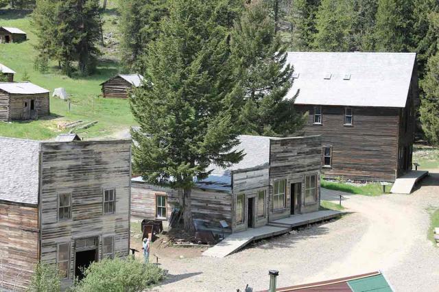
Garnet Ghost Town
A handful of “ghost towns” are found on BLM-managed public land. One of them is the Garnet Ghost Town about an hour east of Missoula in the BLM Missoula Field Office. The BLM acquired the property in the early 1970s and preserved it at that level in partnership with the Garnet Preservation Association. The Association manages a gift shop in the ghost town and an informational website about the town.
"This is one of the best-preserved mining towns in the continental United States,” said Nick Bode, BLM outdoor recreation planner. “We aren’t trying to re-develop the town. Rather, we are embracing its ghost town quality by letting people experience what it’s like to be in a ghost town.”
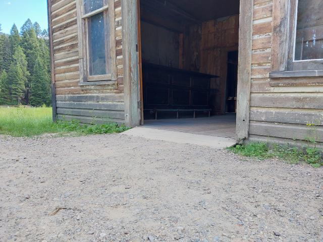
Many buildings have been raised and foundations built as part of the preservation. In the early 2010s, the BLM, Garnet Preservation Association, and local Boy Scouts built and installed ramps to the four main buildings in town. This provides access for people with limited mobility to enter the buildings and experience the history firsthand.
Most visitors come during the summer. Both access roads into town are gravel. Nick recommends avoiding the original access road off Interstate 90 because it’s a steep, one-lane road with no turnouts. The entrance from State Highway 200 is a two-lane road. While this option can be rough in spots, it’s better for most travelers.
To protect the visual aspect of Garnet, the main parking lot is at the top of a hill just outside town. Two accessible parking spaces are available in town for those with a valid permit or license plate. Entry to the town is $10 for visitors 16 years or older. Entry is free with one of the America the Beautiful Passes, such as an Access Pass for U.S. citizens or permanent residents with permanent disabilities, or a Military Lifetime Pass for Gold Star Families and Veterans.
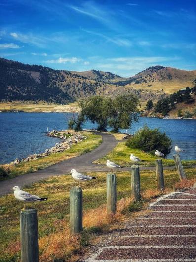
Holter and Hauser Lakes
Another area to explore, which is in the Butte Field Office, is sometimes referred to as the Chain of Lakes Recreation Site. Here you’ll find the most developed BLM recreation sites in Montana/Dakotas, often buzzing with activity.
“Hauser and Holter Lakes are picturesque reservoirs along the Missouri River and the Lewis and Clark Trail,” says Chris McGrath, BLM supervisory outdoor recreation planner. “The reservoirs are popular recreation destinations, providing a wide variety of water-based recreation opportunities and great fishing. The lakes are very special places in the hearts of many people in this region.”
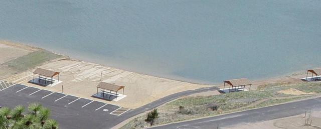
Paved pathways connect three sites on the west side of Hauser Lake. Clarks Bay Day Use Site has accessible picnic areas. The Two Camps Vista commemorative historic site has several interpretive signs surrounding a large, covered viewing platform that overlooks the Missouri River/Hauser Lake. If you want to camp, Devil’s Elbow Campground includes an accessible campsite.
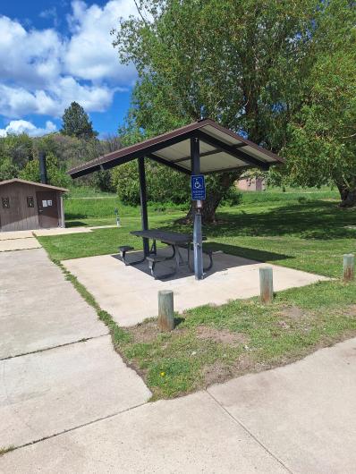
Just a few miles downstream, but 11 miles by road, on the western shore of Hauser Lake sits White Sandy Campground, which includes accessible campsites. These sites have a wide, paved parking spur and a picnic table with extended ends sitting on a hard surface to accommodate visitors in wheelchairs. While some accessible campsites have raised tent pads, grills, and fire rings, these particular sites do not. This campground also includes accessible picnic shelters, which are covered, extended-end picnic tables sitting on concrete near accessible parking.
Clarks Bay and White Sandy each hold an accessible group picnic shelter that are reservable. Visitors must research the picnic shelters and campsites, including the accessible sites in the Devil’s Elbow and White Sandy campgrounds, on www.recreation.gov, the official website and reservation system for Federal government recreation areas. A photo of each accessible campsite and picnic shelter are visible on the www.recreation.gov website, also referred to as “rec.gov”.
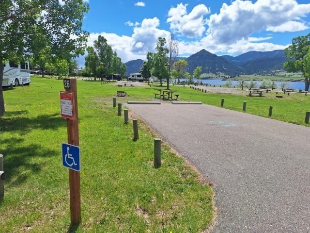
Continuing down the Missouri River is Holter Lake, which also offers accessible camping in three of its campgrounds. Below the dam on the western shore is Holter Dam Campground, the smallest of the campgrounds in the Holter area with 16 campsites. On the eastern shore above the dam is Holter Lake Campground. Further down Beartooth Road is Log Gulch Recreation Site.
Paved trails wind through Holter Lake Campground and Log Gulch Campground, some leading to boat docks and fishing piers. Those sites also include accessible group picnic shelters and accessible campsites that must be reserved on www.recreation.gov.
Scratchgravel Hills Accessible Trail
Many trails in this area are only 18 inches wide. However, the Butte Field Office plans to start construction of a new 1.3-mile, 6-foot-wide accessible trail loop this year in partnership with the Foundation for America’s Public Lands and the Montana Bicycle Guild. The new trail will begin at the Norris Trailhead of the Scratchgravel Hills Special Recreation Management Area, which is just outside the city of Helena, Montana. As a wider trail, it will allow two wheelchairs to safely pass in either direction, for a caregiver or friend to walk side-by-side, or for two deaf people to sign while walking next to each other.
“Although I’m now in a different position, I originally wrote the Scratchgravel Hills Recreation Area Management Plan, which prescribed two accessible trails for the area,” gushed Brad Colin, BLM Montana/Dakotas Accessibility and Trails Program Lead. “So I’m thrilled to see this first trail project come to fruition through valuable partnerships with the Foundation and the Guild. I remain a strong advocate for accessible trails.”
North Central Montana District – Upper Missouri Breaks National Monument
Heading to central Montana is the Upper Missouri Breaks National Monument, which encompasses six wilderness study areas, 149 miles of the Upper Missouri National Wild and Scenic River, and the Cow Creek Area of Critical Environmental Concern.
Although the monument has few paved roads, as shown on the monument map, there are many maintained dirt routes and unmaintained primitive routes. Detailed transportation maps for the western half and the eastern half of the monument are available online or can be purchased at any of the field offices in the BLM North Central Montana District.
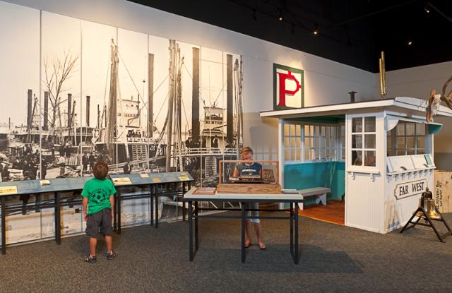
Depending on your ability level, there are several ways to explore this area. Visitors can start at the Missouri Breaks Interpretive Center in the town of Fort Benton to learn about the history, culture, and natural resources of the area. The theater, interactive exhibits, walking trail, and picnic tables are accessible for visitors using wheelchairs or other mobility devices. From there you can decide what else you’d like to do at the monument.
The Missouri Breaks National Back Country Byway is a rugged dirt road that offers three routes through the eastern part of the monument between U.S. Route 191 at the James Kipp Campground and the town of Winfred on Secondary Highway (S-236), also known as PN Bridge Road. A high clearance, 4x4 vehicle is recommended for some sections of this byway, and it is impassable when wet. Contact the Interpretive Center staff at (406) 622-4000 or [email protected] for current road conditions when planning your visit.
Coal Banks Landing Campground and James Kipp Campground offer accessible camping near the river at the western and eastern edges of the monument.
Visitors who want to take advantage of river-related recreation on the Upper Missouri National Wild and Scenic River will find all three classifications identified in the Wild and Scenic Rivers Act of 1968—Wild, Scenic, and Recreational. Camping is available at primitive boat-access only or dispersed campsites. While these sites are too difficult to access for most visitors with limited mobility, they could be well-suited for visitors with some mental health conditions to access. Being in nature, away from roads and crowds, can lower cortisol levels linked to chronic stress, anxiety, and depression.
Eastern Montana/Dakotas District
Finally, we’ll head to eastern Montana, finishing up in North Dakota and South Dakota.
Pompeys Pillar National Monument
As you drive east on Interstate 90, past the town of Billings, Montana, Interstate 94 branches northeast towards North Dakota. On I-94, about 30 minutes from Billings, you’ll see a massive sandstone outcrop standing 120 feet high along the banks of the Yellowstone River known as Pompeys Pillar. This impressive tower was a place of ritual and religious activity, standing guard for thousands of years of human occupation, wearing the scars of hundreds of markings, petroglyphs, and inscriptions left by travelers.
Originally called Iishbiiammaache [eesh-bee-ee-am-ma-A-che] or “The Mountain Lion’s Lodge” by the Crow Tribe, Captain William Clark renamed it Pompy’s Tower after Sacagawea’s infant son, Jean Baptiste Charbonneau. Sacagawea was a Lemhi Shoshone woman who, in her teens, was an interpreter and guide for Meriwether Lewis and William Clark’s expedition westward from the Mississippi River to the Pacific Coast. Jean Baptiste was born in 1805 during the expedition, and Captain Clark took a liking to him, nicknaming him “Pomp,” which led to “Pompey’s Tower.”
Nicholas Biddle, the first editor of Lewis and Clark’s journals, changed the outcrop’s name in Pompey’s Pillar in 1814, finally the apostrophe was removed sometime after 1890 by the U.S. Board on Geographic Names, which discouraged the use of possessive apostrophes in place names.
Pompeys Pillar National Monument protects this culturally and historically important site, including the only remaining physical evidence of the entire 8,000-mile Lewis and Clark Expedition--Captain William Clark’s 1806 signature.
There are several ways to see Clark’s signature, which is carved into the sandstone pillar and protected by a glass casing. A virtual 360-degree tour, found on the national monument’s webpage, can be viewed from anywhere with internet access. A live camera feed is available in the visitor center. Finally, visitors can climb 100 steps to see Clark’s protected signature and other carvings and then climb another 100 steps to reach the top of the pillar for an expansive view of the Yellowstone River valley and surrounding hills and plains.
The visitor center and exhibits surrounding it are set up for people with disabilities. Inside the center are exhibits with audio-visual and interactive components—including the live feed of the monument, closed captioning for the films that play inside the small theater, and tactile maps and directional signs to accommodate visitors with a variety of disabilities. Outside, the wide concrete pathways, benches, interpretive panels, exhibits, and picnic tables can accommodate people with limited mobility.
Debbie Jackson, BLM financial services technician, enjoys visiting at Pompeys Pillar.
“Having low vision, the hardest thing for me when I go to a recreation site is not being able to read the interpretive signs to learn about the area,” she said. “However, I love going to Pompeys Pillar because they have lots of exhibits with audible components, which allow me to learn about the history.”
If you are one of those visitors who likes to learn everything you can about an area before you go there, check out the BLM Montana/Dakotas’ YouTube Playlist of 22 videos about Pompeys Pillar National Monument. The videos include a demonstration of historical weapons, wildlife and habitats, fires and flooding, cultural significance of Crow-style teepees, ancestral skills, Captain Clark’s journey down the Yellowstone River, rock stabilization efforts, and more! The brochure has a map to help orient you to the area, which is in the Billings Field Office.
North Dakota Schnell Recreation Area
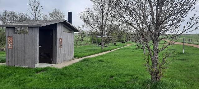
It may surprise some to know that the BLM manages public land, including accessible recreation sites, in North and South Dakota. Continuing east on Interstate 94, about 30 miles east of the town of Dickinson, North Dakota, is Schnell Recreation Area, which is only a few miles off the highway. It was a working cattle ranch before the BLM acquired it in 1993. Managed by the North Dakota Field Office, this quiet six-site campground includes large campsites, giving campers plenty of room to spread out. The site’s one accessible campsite has a sidewalk connecting it to a picnic shelter and vault toilet.
South Dakota Fort Meade Recreation Area
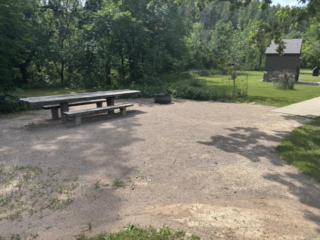
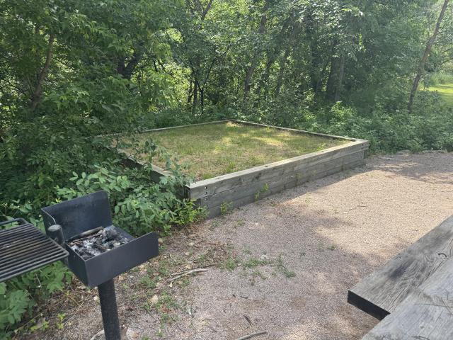
If you keep heading east on Interstate 90 in Billings, you will drive by the famed Sturgis, South Dakota, known for its annual motorcycle rally. Just four miles southeast of Sturgis, just off the highway, is the Fort Meade Recreation Area. Managed by the South Dakota Field Office, the site offers accessible camping at the Alkali Creek Trailhead. Plans are in the works to build an accessible ramp, providing people with disabilities the ability to mount a horse at Alkali Creek Horse Camp. Additional accessible campsites are also planned at both sites.
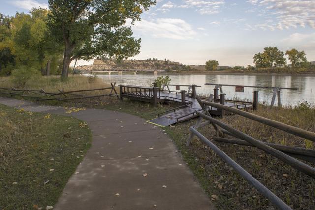
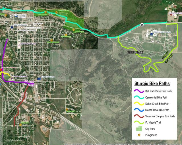
The recently improved Fort Meade Back Country Byway, a 4.5-mile gravel road that cuts through the Fort Meade Recreation Area between South Dakota Highway 34 and Interstate 90, offers another way to see the area. At the north end of the byway, also called Cemetery Drive, is the Fort Meade Trailhead, the closest trailhead for the Centennial Trail and the 7th Cavalry Trail System. Here you can enjoy the meadows and pines on the 2.2-mile accessible Fort Meade trail--a wide, hard-surfaced trail that winds around south and east of the Fort Meade Veterans Affairs Medical Center.
These are only a few of the amazing areas the BLM manages in Montana/Dakotas on behalf of the American people. The BLM is dedicated to ensuring that everyone has an equitable opportunity to use their public lands by providing access to facilities, programs, services, and activities for people with disabilities. The BLM Accessibility Program provides details on opportunities, resources, laws, policies, and guidelines.
Useful Links
- EXPLORE Act – to improve recreation opportunities on, and facilitate greater access to, Federal public land.
- Access Pass – free lifetime pass for U.S. citizens or permanent residents with permanent disabilities.
- Military Lifetime Pass – free pass for Gold Star Families and Veterans.
- Every Kid Outdoors – free pass for fourth graders and their families.
Related Stories
- Birding Aravaipa Canyon: A morning of songs, color, and creekside adventure
- BLM, Partners Enhance Public Access at Popular Recreation Area
- BLM Celebrates America’s 250th Anniversary in Oregon
- Framed for Freedom: Bureau of Land Management Eastern States and the Legacy of National Historic Trails
- Volunteers and Partners Retrace 250 Years of History on the Anza Trail
Office
5001 Southgate Drive
Billings, MT 59101
United States