
White Mountains National Recreation Area Trail Updates
Check for Fire Restrictions in Alaska
Closures and Restrictions
- Nome Creek Road Closure for Construction June 1 - September 30, 2026
Road Closure - Nome Creek Road Construction, June 1 – September 30, 2026
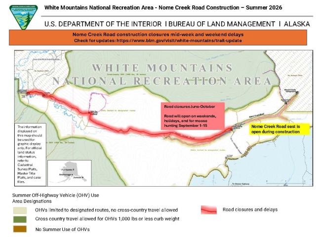
The temporary closure affects the section of road that leads to Ophir Creek Campground from Nome Creek Bridge and will be in effect through September 30, 2026, or until construction is completed, whichever is sooner.
From 6 a.m. on Mondays to 7 p.m. on Fridays, the western part of Nome Creek Road may be closed for road improvements and culvert replacement to improve drainage and reduce the likelihood of spring washouts. During the closures, the public will not be able to access recreation sites along the road, including Table Top Mountain Trail, Nome Creek Airstrip, Moose Creek Landing, Ophir Creek Campground, and the put-in for Beaver Creek Wild and Scenic River.
The road will be open on weekends, federal holidays, and for moose hunting September 1-15. When the road is open, travelers should expect traffic controls and delays of up to 20 minutes.
The eastern section of Nome Creek Road will not be under construction and will remain open, providing summer access to Quartz Creek Trail, Mount Prindle Campground, and upper Nome Creek.
Signs will be posted on the Steese Highway, US Creek RD, and in the Nome Creek Valley to notify the public of the temporary closure. BLM law enforcement rangers and other employees will be in the area to enforce the temporary restriction on motor vehicles.
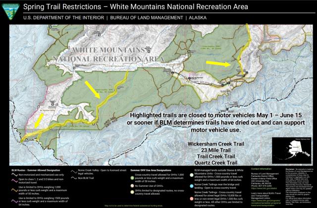
- Spring Motor Vehicle Trail Restrictions May 1 - June 15
The spring restrictions are in effect through June 15, unless modifications are announced. Modifications will be included here and shared on facebook.
The Bureau of Land Management (BLM) Eastern Interior Field Office will begin the summer season travel limitations for the White Mountains National Recreation Area on May 1. As the summer season travel limitations take effect, off-highway vehicles will be temporarily restricted from the Wickersham Creek Trail, Trail Creek Trail, 23 Mile Trail, and Quartz Creek Trail to prevent damage to wet trails during the transition to summer.
The temporary restrictions begin May 1 and last until 12:01 a.m. on June 15 or until BLM staff determines that trails are sufficiently dry to allow off-highway vehicles use that will not damage trails. This is being implemented consistent with the Eastern Interior White Mountains Record of Decision and approved Resource Management Plan and White Mountains National Recreation Area Travel Management Area Travel Management Plan. During the temporary restriction, the trails remain open for hiking and other non-motorized use.
Signs will be posted at the trailheads to notify the public of the temporary restriction. BLM law enforcement rangers and other employees will be in the area to help inform the public about the special restriction. BLM staff will assess trail conditions during May and June and will lift the temporary restriction as soon as the trails have been determined to support off-highway vehicle use.
To learn more about how to use the BLM’s maps to navigate using your smartphone’s GPS, even in areas without cellular reception, visit the BLM Georeferenced Maps webpage.
- Nome Creek Trail Closure for Stream Restoration July 6 -August 31
Trail Closure – Portion of Nome Creek Trail, July 6 – August 31, 2026
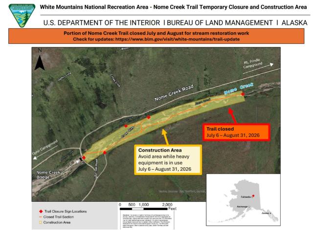
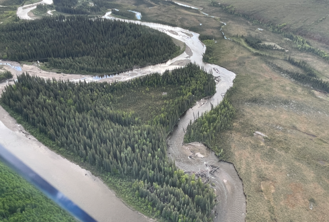
An approximately 1.5-mile portion of the Nome Creek Trail will be temporarily closed for stream restoration work from July 6 through August 31, 2026, or until construction is completed. The temporary closure is directly upstream from the Nome Creek Bridge
The temporary trail closure is required because heavy equipment work will commence in the surrounding area to perform restoration on the stream and surrounding floodplain, stock piling and placing material. The public is advised to avoid the surrounding restoration project area (approximately 70 acres) while activities are ongoing. The project area will include a staging zone for heavy equipment, fuel, and a construction camp.
Signs will be posted along the trail in the Nome Creek Valley to notify the public of the temporary closures. BLM law enforcement rangers and other employees will be in the area to enforce the temporary restriction on motor vehicles.
Summer recreation in the White Mountains
May 1-October 14
Numerous and diverse opportunities for summer recreation can be found in the White Mountains. The summer season runs May 1 through October 14, but the transition into and out of winter is variable, so season modifications or other restrictions are sometimes needed. Modifications will be included here and shared on facebook.
During the summer, motorized vehicle use is limited to protect sensitive resources, however, the entire area is open to all forms of non-motorized use, including hiking, equestrian, and bicycling use. To help you plan your visit the Summer Recreation Map provides information about access and BLM recreation sites.
To learn more about using the BLM’s maps to navigate using your smartphone’s GPS, even in areas without cellular reception, visit the BLM Georeferenced Maps webpage.
Update – June 12, 2026
This summer, recreation opportunities may be impacted by construction in the Nome Creek Valley, but there many other great places to enjoy. If you want help finding a place to avoid the construction, contact the BLM Fairbanks Public Room at 907-474-2200 or 1-800-437-7021 (toll free) or stop by 222 University Avenue, Fairbanks, Alaska.
Summer travel and transportation limitations are in effect with temporary motor vehicle restrictions through June 15 on Quartz Creek Trail, Wickersham Creek Trail, Trail Creek Trail, and 23 Mile Trail. Road Construction will close the western portion of Nome Creek Road Monday through Friday. During the closures, the public will not be able to access recreation sites along the road, including Table Top Mountain Trail, Nome Creek Airstrip, Moose Creek Landing, Ophir Creek Campground, and the put-in for Beaver Creek Wild and Scenic River. When the road is open on the weekends, expect traffic controls and delays up to 20 mins.
The eastern section of Nome Creek Road will not be under construction and will remain open, providing summer access to Quartz Creek Trail, Mount Prindle Campground, and upper Nome Creek.
The recreation staff is monitoring the trails and will remove the motor vehicle restriction when conditions allow. Monitor this page and facebook for updates.
The Upper Beaver Creek Wild and Scenic River continues to have hazardous channel. The channel has a strong current that could draw watercraft into the new channel that is choked with hazardous woody debris.
- Cabins and Campgrounds
Campgrounds
Three campgrounds are open from late-May until the snow flies in October:
No reservations. Visitors can pay fees using the Scan & Pay app on a mobile phone. Because there is no cell phone reception at the site, you will need to download the required Recreation.gov mobile app prior to traveling to the Campground, selecting the Scan & Pay option.
Cabins
Reservation required. Maximum 3-night stay.
Use of the public use cabins requires reservations through Recreation.gov.
Two trail shelters are free of charge and used on a first come, first served basis.
- Winter Recreation October 15 - April 30
Reaching the heart of the White Mountains becomes much easier in the winter, when creeks, rivers, and bogs are frozen. In winter, visitors travel by ski, snowshoe, fatbike dog team and snowmobile to enjoy the 13 public-use cabins and 250 miles of groomed trails that make the White Mountains one of Interior Alaska's premier winter destinations.
Main points of access along the Elliott Highway include Wickersham Dome Trailhead at mile 28, and Colorado Creek Trailhead at mile 57. On the Steese Highway, main access is at McKay Creek Trailhead at mile 42.
Note that the U.S. Creek Road at mile 57 and the Nome Creek Road are not maintained during the winter, but they sometimes have regular use that packs trails.
During the winter season, the White Mountains are open to the use of snowmobiles weighing up to 1000 pounds curb weight and up to 50 inches wide in addition to all forms of non-motorized use. Winter trails are open to both snowmobiles and nonmotorized users, except for the non-motorized Ski Loop Trail and Summit Trail leaving from Wickersham Dome Trailhead.
Wheeled off-highway vehicles (OHVs) are not allowed on the White Mountains National Recreation Area’s trails during the winter. In general, wheeled motor vehicles are not allowed because they churn up rocks and create ruts through the snowpack. This degrades trails for other users and makes trail grooming operations more challenging. Although there is no winter maintenance, roads in the area remain open to wheeled OHVs and highway vehicles as conditions allow. Throughout the year, these areas are open to non-motorized use, including hiking, biking and equestrian use.
Check out the Know Before You Go below for tips and links.
Here are some resources to help you plan your visit:
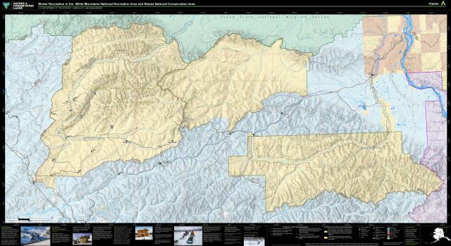
Winter Recreation Map - Summer Recreation May 1 – October 14
A typical summer season runs May 1 through October 14, but the transition into and out of winter is variable, so sometimes season modifications or other restrictions are announced.
Modifications will be included here and shared on facebook.
During the short summers, visitors hike, float, hunt, fish, pan for gold and camp under Alaska's 'midnight sun.'
Nome Creek valley is one of the prime access points for summer recreation with access to two campgrounds, trails, a gold-panning area and a departure point for float trips on Beaver Creek Wild and Scenic River. It can be reached via the US Creek Road, Steese Highway Milepost 57. These gravel roads can be bumpy but are suitable for use by highway vehicles.
To protect sensitive resources, vehicles must remain on BLM routes designated for their use unless traveling in an area designated open to cross-country motorized travel. The entire area is open to all forms of non-motorized use, so feel free to explore off-trail.
The most popular places to ride OHV’s is in the Nome Creek tailings and the Quartz Creek Trail. Most managed routes are open to OHVs weighing 1,000 pounds or less curb weight and a maximum width of 50 inches. A few routes are designated for larger motor vehicles weighing up to 1,500 pounds curb weight and up to 64 inches wide, including the Quartz Creek Trail and the Wickersham Creek Trail to Lee’s Cabin from the Wickersham Dome Trailhead. Please be aware that many large OHVs, ARGOS, and four-door side-by-side UTVs are too large for use on most routes and cross-country travel on BLM-managed lands.
E-bikes are allowed on all motorized routes and two designated trails:
Most of the cabins become difficult to reach in the summer, but a few are regularly used such as Fred Blixt Cabin and Lee’s Cabin.
Check out the Know Before You Go tab below for tips and links.
Here are some resources to help you plan your visit:
- Trail Maps
Web Map: The new interactive Alaska Travel Management web map includes information on routes and cross-country travel areas. Toggle on and off trail and area layers for winter or summer, scroll across Alaska and zoom in to get detailed information. You can even create custom georeferenced PDF maps for use in the field by selecting print PDF.
Georeferenced PDF maps: these digital maps are designed for use on smart phones and tablets. With a free app the map shows your current location even if cell coverage is not available. Learn more about how to use these free digital maps and browse the full collection of BLM georeferenced PDF maps.
- Know Before You Go
Visitors are at their own risk and should be prepared for any situation and extreme weather conditions. Weather and trail conditions change rapidly.
Share a trip plan (State Troopers form) with family or friends before you head out
Please check back here for updates before you head to the field and follow our Facebook page for regular and emergency updates.
- Check the weather before you head out.
- Check the highway conditions on 511.alaska.gov before you head out.
- Download our maps for White Mountains on your phone for off-grid use.
- Bring more water, food, and fuel than you should need for your trip.
- Bring a satellite communication device, more than one if possible.
- Plan for mechanical breakdowns and weather conditions to deteriorate rapidly.
- If you become stranded, do not separate from your party.
- Alaska is Bear Country: No matter the season, always remain bear aware.
- Special Rules
The following activities are prohibited in the White Mountains National Recreation Area:
- use of motorized equipment for mineral collection for personal use
- camping at one site for a period longer than 10 days in any calendar year
- discharging of firearms within one-quarter mile of public recreation cabins, campgrounds, as well as across or along roads and trails
- leaving burning or smoldering campfires unattended
- constructing permanent or semi-permanent structures, including cabins, caches, water dams or diversions without written authorization from the BLM authorized officer (subject to valid existing rights)
- Planning and Projects
Wickersham Dome Trailhead parking area expansion - dates to be determined
- Trails will remain open during construction. Alternative parking and short trail re-routes may be needed.
- Contact Us
For up-to-date information or questions about visiting the White Mountains or other BLM-managed lands here are some ways you can reach us:
- (907) 474-2200 or 1-800-437-7021
- [email protected]
- Visit our BLM Public Room at the Fairbanks District Office, 222 University Ave., Fairbanks, Alaska