Summer Recreation in the White Mountains National Recreation Area and Steese National Conservation Area Georeferenced PDF Map
During the summer, May 1 – October 14, motorized vehicle use is limited to protect sensitive resources; however, the entire area is open to all forms of non-motorized use, including hiking, equestrian and bicycling use.
The map includes BLM recreation sites, routes and motor vehicle limitations for the White Mountains National Recreation Area and Steese National Conservation Area.
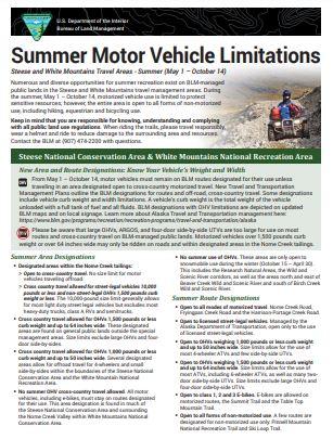
The Summer Motor Vehicle Limitations factsheet provides an overview of the new designations for off-highway vehicles in the White Mountains National Recreation Area and the Steese National Conservation Area.
To make customizable geoPDF maps of the area check out the Interactive Alaska Travel Management Map.
Have questions? Contact the BLM Public Room in Fairbanks at (907) 474-2200 or 1 (800) 437-7021.
Stay tuned for a new expanded map for winter recreation.
View and download the map
To open the map in your web browser:
- Click the hyperlinked filename at the bottom of the page. The map will open in a new web browser window.
- Download the map by selecting the download arrow in the upper right.
If you are using a mobile device, the file may be too large to view in your mobile web browser and may appear blank. To view it, you will need to download it into your georeferenced PDF map application.