
Nome Creek Valley Georeferenced PDF Map
NOTICE: Nome Creek Road repair with midweek closures May – October 2025
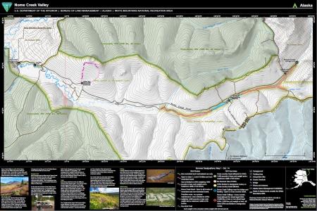
Monday – Friday the Nome Creek Road to Ophir Creek Campground will be closed to the public for road improvements and culvert replacement.
When planning your visit go to the trail updates webpage for access information, current events and notices about temporary closures or restrictions.
Click the filename at the bottom to open the map.
During the summer, May 1 – October 14, motorized vehicle use is limited to protect sensitive resources; however, the entire area is open to all forms of non-motorized use, including hiking, equestrian and bicycling use.
Motor vehicles must remain on BLM routes designated for their use unless traveling in an area designated open to cross-country motorized travel.
For a map of the surrounding area, see the Summer Recreation in the White Mountains National Recreation Area and Steese National Conservation Area.
The Summer Motor Vehicle Limitations factsheet provides an overview of the new designations for off-highway vehicle use in the area.