Uncompahgre Field Office Seasonal Closures
The Bureau of Land Management (BLM) enforces seasonal closures across public lands managed by the Uncompahgre Field Office in Colorado.
Seasonal closure dates and boundaries are subject to change.
For additional information, including a complete list of closures and maps, please contact the Uncompahgre Field Office at 970-240-5300. View interactive map showing all BLM Colorado seasonal closures.
Seasonal Closures
County roads are not subject to BLM closures. Contact the county for questions about county road access.
- Dry Creek Recreation Area
Closures are intended to prevent disturbance to wintering big game:
Map 1: Public lands in the following area are closed to motorized (OHVs, ATVs, full-sized vehicles) and mechanized (bicycle) travel from December 1 to March 31. The area remains open to non-motorized/ non-mechanized recreation, such as hiking and horseback riding. This includes routes north of Transfer Road within the Sandy Wash and Roatcap area.
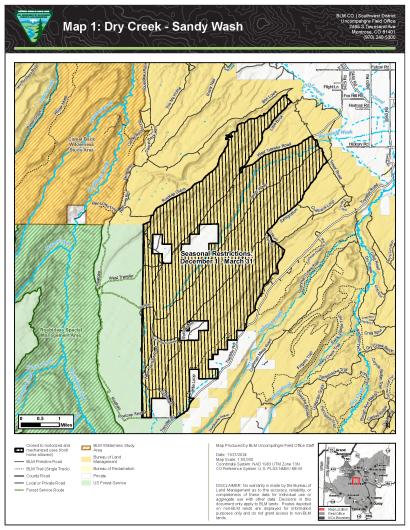
Map 1: Sandy Wash, Dry Creek Recreation Area. Click on map to open PDF. Map 2: Public lands in the following area are closed to motorized and mechanized travel from December 1 to April 15. The area remains open to non-motorized/non-mechanized recreation such as hiking and horseback riding. This includes routes south of Rim Road starting with the route that drops into Shavano Valley and then south and east of Rim Road until it connects to 90 Road then north of 90 Road.
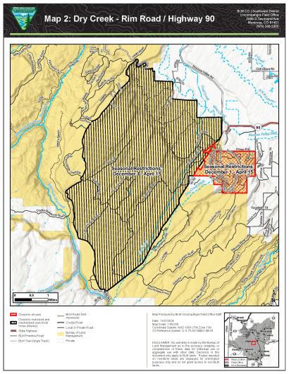
Map 2: Rim Road/Highway 90, Dry Creek Recreation Area. Click on map to open PDF. Map 3: Public lands in the following area are closed to all modes of travel, including mechanized (bicycle), foot, and equestrian travel, from December 1 to April 15. This includes routes south of Highway 90 in the Electric Hills area. This closure does not include Montrose County's Staging Area and Rec Site.
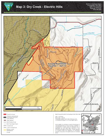
Map 3: Electric Hills, Dry Creek Recreation Area. Click on map to open PDF. - Ridgway Trails Recreation Area
Closures are intended to prevent disturbance to wintering big game:
Map 4: Public lands in the following area are closed to all modes of travel including mechanized (bicycle), foot and equestrian from December 1 to April 30. This includes the Ridgway Area Trails (RAT).
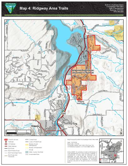
Map 4: Ridgway Area Trails. Click on map to open PDF. - Gunnison Gorge National Conservation Area
Closures are intended to protect sensitive Gunnison sage-grouse habitat, prevent disturbance to wintering big game, and protect soils from erosion and damage:
Map 5: C-77 (Green Mountain), Black Ridge, and Red Canyon roads are closed to motorized and mechanical use from December 1 to May 15 and are closed to all human use from March 15 to May 15. This includes portions of Black Ridge and Fruitland Mesa east of the Gunnison Gorge Wilderness, west of the Black Canyon Road, south of the Smith Fork drainage and north of Black Canyon of the Gunnison National Park.
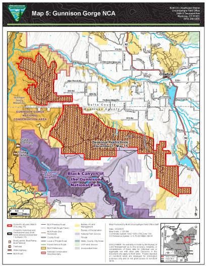
Map 5: Gunnison Gorge National Conservation Area. Click on map to open PDF. - Jumbo Mountain Special Recreation Area Management, Zone 2
Closure is intended to prevent disturbance to wintering big game:
Map 6: Routes in Zone 2 are closed to all uses from December 1 to April 15. This includes routes east of the powerline to the top of Jumbo Ridge Trail. Jumbo Ridge, Rock n Roll, and Shitake Ridge routes are closed to all modes of travel, including mechanized, foot, and equestrian, to protect golden eagles throughout their breeding cycle December 15 to July 15.
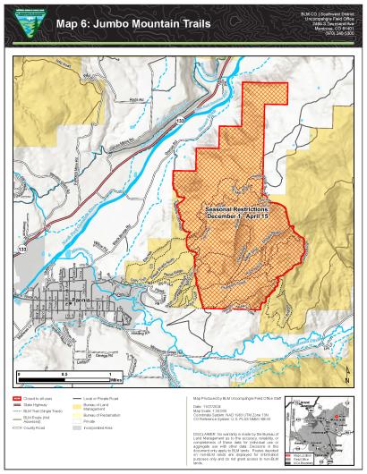
Map 6: Jumbo Mountain Trails. Click on map to open PDF. - Burn Canyon Area
Closure is intended to prevent disturbance to wintering big game:
Map 7: Public lands in the following area are closed to motorized and mechanized travel from December 1 to April 30. The area remains open to non-motorized/non-mechanized recreation such as hiking and horseback riding.
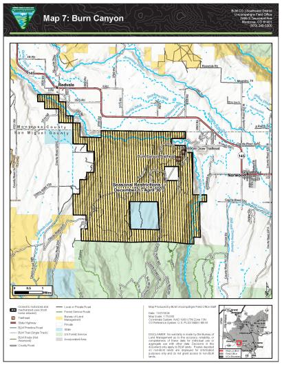
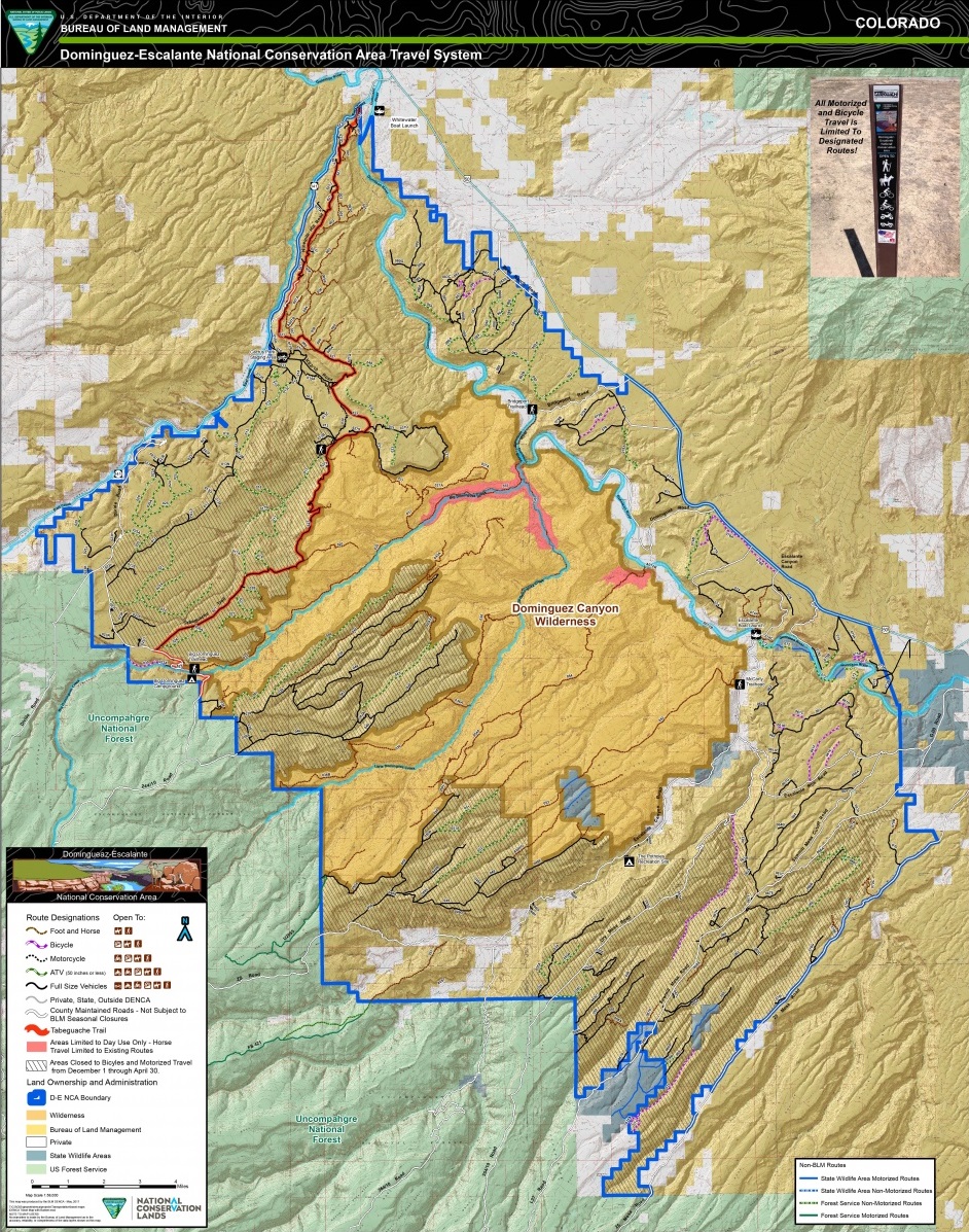
Map 7: Burn Canyon. Click on map to open PDF. - Dominguez-Escalante National Conservation Area
Map 8: Closures are labeled on the map legend.
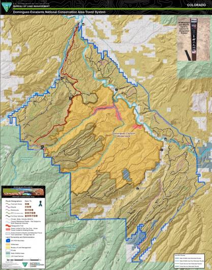
Map 8: Dominguez-Escalante National Conservation Area. Click on map to open PDF.