Gunnison Field Office Seasonal Closures
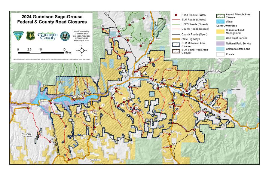
The BLM, in coordination with Gunnison County and the U.S. Forest Service, closes roads to all motorized use seasonally from March 15 through May 15 to protect the Gunnison sage-grouse during mating and nesting season and prevent road damage during wet spring conditions. Roads may be closed earlier if conditions warrant. The cooperation of the public is required to successfully implement these closures:
- BLM 3038 Kezar Basin (closure just off Hwy 149 at Powerline)
- BLM 3038 Nine Mile Hill (closure just off Hwy 149)
- BLM 3545 The Backdoor Road (Hartman NW entrance)
- BLM 3500 Hartman Rocks McCabe Lane Entrance (McCabe’s Lane Entrance to Hartman Rocks)
- BLM 3550 Powerline Rd (closure off Gold Basin Road)
- BLM 3580 Hartman Rocks (closure off Powerline Rd; route is south of Powerline)
- BLM 3550 Hartman Rocks Powerline Road (closure east of Beaver Creek)
- Hartman Rocks West Access (closure to southern part of Hartman Rocks)
- BLM 3580 off Gold Basin Road (south entrance to Hartman Rocks)
- BLM 3107 Cabin Creek Road (closure just off Hwy 50)
- BLM 3106 Dry Gulch Road (closure just off Hwy 50)
- BLM 3061 Sewell Rim Road (closure just off Hwy 50)
- BLM 3096 Woods Gulch East
- BLM 3094 Tomichi Dome Rd (closure off Hwy 50)
- BLM 3076e So. Parlin Flats Access Rd (closure off Hwy 114 at mile marker 5)
- BLM 3185 Camp Kettle Gulch (closure off Hwy 114)
- BLM 3185 Poverty Gulch (closure off CR 45)
- BLM 3162 Krueger Ranch Rd (closure off Hwy 114, locked all year)
- BLM 3067 (closure off Gold Basin Road – at shooting range)
- BLM 3211d Hwy 50 Powerline Road (closure at BLM boundary approx. 0.1 mile north of Hwy 50)
- BLM 3233 Haystack Gulch Road (closure just off Hwy 50)
- BLM 3037b3 North Willow Creek (closure just off Hwy 50)
- BLM 3211e (closure just off Hwy 50)
- BLM 3226b1 McIntosh Spur (gate at BLM boundary, Access to McIntosh Mountain Loop)
- BLM 3072a2 (gate off west side of Hwy 114 at mile 3.5, access to Powerline)
- BLM 3074 (Bead Creek Rd., west side off Hwy 114)
- BLM 3075 (Rock Creek Rd., west side off Hwy 114)
- BLM 3147 (Powerline Rd., east side off Hwy 149)
- BLM 3042 (east side off Hwy 149)
- CR 61 Pole Creek (closure off CR 31 South Willow Creek Rd/Vulcan Rd)
- CR 25 Pine Creek (closure near to Hwy 50 just past end of private plowing)
- CR 25 Pine Creek (closure at cattle guard past Blue Mesa Estates appx 3 miles from Hwy 149)
- CR 26 Sapinero Mesa (closure off Hwy 50 at current winter closure gate)
- CR 26 Sapinero Mesa (closure on Hwy 149 side at winter closure gate)
- CR 32 McCabe Lane (closure at first cattle guard past Moncrief Ranch)
- CR 818 Wiley Lane (closure at intersection with Mill Creek Road on north end)
- CR 7 Miller Lane (closure at existing gate)
- CR 818 Wiley Lane (closure at cattle guard at private/BLM boundary on the south end)
- Airport Road (W Mountain) (closure at intersection of W Mountain Ranch Rd and CR 38)
- CR 51B Sun Park (closure just past intersection with Overlook Drive)
- CR 743 Lost Canyon (closure at existing winter closure gate)
- CR 72 Tomichi Heights (closure at gate at BLM boundary)
- CR 42 Six Mile Lane (closure at existing gate on BLM boundary)
- CR 43 South Parlin Flats (closure at Hwy 114 at mile marker 7)
- CR 43 South Parlin Flats (closure approximately 0.4 miles from Hwy 50)
- CR 62 Razor Creek (closure at private boundary)
- CR 60 North Parlin Flats (closure off CR 76 - Quartz Creek Road)
- CR 802 Woods Gulch North (closure off CR 44 - Woods Gulch Cutoff)
- Woods Gulch Powerline Access (closure off CR 44 - Woods Gulch Cutoff)
- CR 802 Woods Gulch South (closure off CR 44 - Woods Gulch Cutoff)
- FS 829 Flat Top, Henkel Road (closure off CR 730 – Ohio Creek)
- FS 860 Flat Top, Smoky Bear Road (closure just off Hwy 135)
- FS 862 Flat Top (closure off FS 860)
- FS 863 Flat Top (closure off FS 860)
- FS 955 Flat Top (closure off FS 829)
- FS 603 Flat Top (Alkali Creek)
All non-motorized trail users are asked to use Gunnison Basin roads and trails only after 9 a.m. during this time to help reduce disturbance to Gunnison sage-grouse.
BLM also has closures in place on Signal Peak trails to protect Gunnison sage-grouse. Ridge Trail West, Cranor Hill Trail, Shoelace, Chicken Scratch, and Rasta Gulch trails are closed to all uses from March 15 to May 15.
Some Hartman Rocks Recreation Area wet weather gates close for mud season; many of these gates are already closed for winter grooming. Gates reopen when the roads and trails dry out. Please tread lightly and limit use of muddy trails until conditions improve.
Printable Gunnison area closures list and map
For more information on these closures, please contact the BLM Gunnison Field Office at (970) 642-4940.
In response to changing weather conditions, wet weather gates may be opened or closed at any time. Please contact (970) 642-4940 for complete updates.
