
BLM Wyoming Supports Public Lands Access Data Delivery Project
Adam Carr, Access Program Manager, Montana/Dakotas State Office
Progress toward a database that will help members of the public find existing legal access across non-federal lands took a big step forward recently with the assistance of two BLM Wyoming field offices.
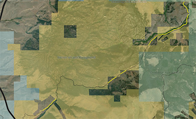
across private lands. The easements are indicated
by the yellow lines.
The Public Lands Access Data Delivery Project (PLADD) is a bureau-wide effort, funded by multiple programs from Headquarters and coordinated via a project manager and realty specialist from the Montana/Dakotas State Office.
As the Bureau prioritizes improving access to public lands, the main goal of the PLADD is to create and publish a ‘public-facing’ geodatabase that displays legally perfected access across private and other agency managed lands.
Easements and reservations in patents are kept in Lands and Realty casefiles and are the legal documents needed to digitize these access rights. Besides making it easier for people to find their way while respecting property rights, this information will also support BLM planning and management decisions such as travel planning, a myriad of land management and resource issues, and the need to comply with section 4105 of the Dingell Act and section 4 of the MAPLand Act.
The Pinedale and Newcastle field offices recently participated in the PLADD initial quality control (QC) review of recently delivered GIS data depicting access to BLM lands via BLM-held access easements.
Contractor-created GIS data for the Pinedale and Newcastle field offices was provided along with instructions and information to support an interdisciplinary review of the PLADD data. The QC process will ensure that the data captures all the potential easements that provide access to public lands, the information (attributes) displayed is correct, and that the authorized officer concurs with the publication of data for public use.
The willingness of managers and staff in Pinedale and Newcastle to engage and provide feedback during the review of the PLADD data was invaluable. The feedback, ideas and lessons learned from working with the field offices has been used to improve the QC process. Support from the Wyoming State Office and the Pinedale and Newcastle field offices is greatly appreciated and helps move the project and Bureau closer to the goal of providing GIS data showing public access to BLM managed public lands.
A future Instruction Memorandum from HQ will provide detail on how data associated with the PLADD will be managed and supported at the field and state office levels. Data from the project will be delivered to states later this summer and throughout the fall to start the QC process leading to future publication of the data.
Visit this webpage to view how PLADD data is depicted for Montana/Dakotas as their data was created as a pilot project for this effort.
Related Stories
- Preserving a Legacy in Stone: The Race to Save Pompeys Pillar
- BLM Billings Field Office Completes Dilworth Creek Riparian Restoration Project
- Boating Paradise: GAOA Funding Enhances Popular Recreation Site Along Montana’s Yellowstone River
- Commemorating 150 Years: The St. Patrick’s Day Fight Along the Powder River
- Snapped enamel and crushed bone: A Moment Frozen in Time