
BLM Arizona Office Locations Map
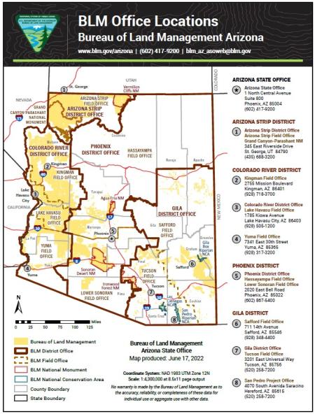
This free, downloadable PDF map shows the locations of all Bureau of Land Management (BLM) offices in Arizona, including the Arizona State Office, district offices, field offices, and the San Pedro Project Office.
- BLM lands are shown in yellow. It represents all public lands in Arizona managed by the BLM.
- BLM district offices are shown with a solid dark brown boundary. Four district offices oversee BLM operations across Arizona: the Arizona Strip, Colorado River, Phoenix, and Gila district offices.
- BLM field offices are shown with a dashed dark brown boundary. Seven field offices manage day-to-day operations within their districts: the Arizona Strip, Kingman, Lake Havasu, Hassayampa, Lower Sonoran, Yuma, Safford, and Tucson field offices.
- BLM national monuments are shown with a red boundary. This map includes the Grand Canyon-Parashant, Vermilion Cliffs, Agua Fria, Sonoran Desert, and Ironwood Forest national monuments. Because this map was created in 2022, it does not include the Baaj Nwaavjo I'tah Kukveni – Ancestral Footprints of the Grand Canyon National Monument, which was established in August 2023.
- BLM national conservation areas are shown with a teal boundary. Three national conservation areas are administered by the BLM in Arizona: San Pedro Riparian, Las Cienegas, and Gila Box Riparian national conservation areas.
- County boundaries are shown in light gray. All 15 Arizona counties are displayed for geographic reference: Apache, Cochise, Coconino, Gila, Graham, Greenlee, La Paz, Maricopa, Mohave, Navajo, Pima, Pinal, Santa Cruz, Yavapai, and Yuma.
Each office location is marked with a numbered point on the map and listed in a directory on the right side of the map with its mailing address and phone number. Please note that the location of the Arizona Strip District Office has changed since this map was produced. Visit the office page for current address and contact information.
The map was produced by the BLM Arizona State Office on June 17, 2022, using the NAD 1983 UTM Zone 12N coordinate system at a scale of 1:4,300,000 for standard 8.5×11-inch page output.
For a complete list of BLM Arizona office addresses, phone numbers, and contact information, visit the BLM Arizona State Office page or contact us by phone at 602-417-9200 or by email at [email protected].
No warranty is made by the Bureau of Land Management as to the accuracy, reliability, or completeness of these data for individual use or aggregate use with other data.