
The Takelma Tribe Today
What Happened to the Takelma?
Although there were small numbers of settlers in the region as early as the late 1820s to the late 1840s, it wasn't until gold was discovered in the Rogue Valley in 1851 that a flood of prospectors and settlers came into the area. Their incentive was also bolstered by the 1850 Oregon Donation Land Act (ODLA) that offered "free land claims." A settler could claim one square mile (640 acres). Prior to 1851, conflicts between the settlers and Indians were limited to brief attacks on livestock herders and immigrants along the Oregon California Trail (Beckham 1993:65-68). However, the larger floods of prospectors to southwest Oregon created the beginning of serious conflict between the Native groups inhabiting the region and the settlers.
As the settler population continued to increase, their desire to own land and control the natural resources on the land also increased. Fences were built around lands the Indians had lived on and maintained for thousands of years. Mining and settlement disturbed the natural environment, depleting and killing the natural resources the Native Americans relied upon for food. Mining run-off clouded and choked the streams killing the salmon and lamprey. The settlers' hogs were allowed to run wild eating the acorns and rooting up camas bulbs. Cows trampled root crops. The settlers hunted extensively, decimating the deer and elk populations. Southwest Oregon was rich with resources when the settlers arrived and to them, the Native populations were an obstacle in their ability to settle in the region.
Friction and conflicts between miners and settlers and the Rogue Valley Tribes continued to escalate until the summer of 1853, when open warfare erupted culminating into the "Rogue River Indian Wars." In an attempt to end these conflicts, in September 1853 through November 1854, several treaties were signed that ceded Tribal land. A temporary reservation was established between Upper Table Rock and Evan's Creek, and was known as the Table Rock Reservation. Tribes from all over the region were moved to this location. However, conflicts continued and soon open warfare was again imminent.
In November 1855, the Siletz or Coast Reservation was established by President Franklin Pierce. In 1856, Native people throughout Northern California and Southwest Oregon, including the Takelma, were removed from their ancestral lands and were relocated to the Coast Reservation, a distance of approximately 265 miles. They made this forced journey on foot, traveling for 33 days under the "escort" of 106 military personnel. Many Indians died on their way to the reservation. In June of 1857, an encampment near the Siletz reservation holding 60 women and children from the Rogue region was established by President James Buchanan as a second reservation called the Grand Ronde.
Change of diet and starvation, exposure to a different climate and disease rapidly weakened the survivors. Repeated requests to return to their homeland were denied. Eventually, those who had been relocated north from the Rogue Valley began to accept that they were members of the Confederated Tribes of Siletz or Confederated Tribes of Grand Ronde, depending on where their family made their home. They were no longer separate tribes, but part of a larger, intertribal group.
In 1865 and 1875, the once large Siletz Reservation was reduced by a total of about 900,000 acres. The people's rights upon their permanent reservation according to treaty stipulation were unclear. Allotments were issued to tribal members at Siletz and Grand Ronde. Tribes were forced to cede most of their unallotted lands. Tribal land and resource bases continued to diminish through the early 1900s until the 1950s when the Western Oregon Tribes were targeted for termination. In 1954, Congress passed the Western Oregon Termination Act, severing recognition of all tribal entities in western Oregon. By 1956, the last of the Siletz Reservation and Grand Ronde Reservation lands were taken by the Bureau of Indian Affairs.
Where are the Takelma Now?
In the early 1970s the Confederated Tribes of Siletz Indians began reorganizing and holding meetings again. The major topic was discussion of the effects of termination and possible ways to recover from it. After the Menominee Tribe of Wisconsin was restored to federal recognition as a tribe in 1973, the Siletz people started on the same path. In 1977, the Confederated Tribes of Siletz Indians became the second tribe in the nation to have their termination act repealed with passage of the Siletz Restoration Act. The Grand Ronde Community also reorganized and was restored in the 1980s.
Today, Takelma descendants carry with them a combination of old and new cultural traditions and knowledge. Many continue to reside on or near the Siletz and Grand Ronde reservations.
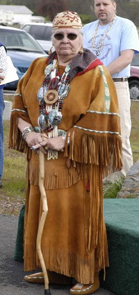
Agnes Baker-Pilgrim is the grandchild of George Harney, a full-blooded Takelma who was the first elected Chief of the Confederated Tribes of Siletz Indians. Agnes has returned to the Rogue Valley and today their voice can be heard strong and clear, proving that the spirit and blood of their people are still with us. In different lectures given over the past 10 years Agnes talks about their people:
"Many people mistakenly believe that all the Rogue River Indians were wiped out a century and a half ago. It's not true; there are more than 70 descendants of Chief Harney alive today. I am a living link with the ancestors of this land."
Agnes Baker-Pilgrim is actively involved in the support of indigenous people's rights and the sustainability of our environment.
Who Settled the area after the Takelma?
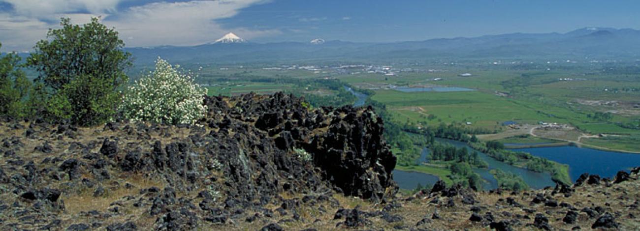
After 1856, following the removal of the Native Americans from the region, agriculture developed around the Table Rocks. In 1872, a Table Rock post office opened up, followed by a school district in 1879. Recreational hikers began to enjoy the Table Rocks during the late 1800s and early 1900s. Development ensued as more grazing lands were cleared, dirt roads were built, and even an airstrip was constructed on the top of Lower Table Rock. In 1978, the Nature Conservancy began a campaign to raise $500,000 to preserve the Rocks, hoping to prevent the construction of a subdivision in the bowl of Lower Table Rock (Atwood 1994-5: 531). The Conservancy successfully raised the needed funds. A cooperative land management relationship was forged with three land owners of the Table Rocks, the Medford BLM and the Nature Conservancy. Today, these three entities work to preserve the land and to educate the public about these unique and historically rich geological formations. Not only do the Table Rocks provide a wonderful opportunity for environmental education, but they remain full of spiritual representation and the heart of the ancestral homelands for the Takelma people.
- References
-
Aiken, Melvin C.
- 1990 Southwest Oregon: Living With the Land. In Living With the Land: The Indians of Southwest Oregon. Nan Hannon and Richard K. Olmo, eds. Pp. 1-5. Medford, Oregon: Southern Oregon Historical Society.
Atwood, Kay
- 1994-95 As Long as the World Goes On: The Table Rocks and the Takelma. Oregon Historical Quarterly 95(4): 516-532.
Beckham, Stephen Dow
- 1993 Takelman and Athpascan Lifeways and History, Rogue River Corridor-Applegate River to Grave Creek: Investigations for Interpretive Programs. Eugene, Oregon: DOI Bureau of Land Management, Medford District Office.
Gray, Dennis J.
- 2003 Flounce Around Fuels Cultural Resource Inventory. Medford, Oregon: U.S.D.I. Bureau of Land Management.
- 1993 Analysis of the Fish Lake Artifact Collection, Site 35JA163, Jackson County, Oregon. Medford, Oregon: U.S.D.I. Bureau of Land Management.
- 1987 The Takelma and their Athapascan Neighbors: A New Ethnographic Synthesis for the Upper Rogue River Area of Southwestern Oregon. Eugene, Oregon: University of Oregon Anthropological Papers No. 37.
Kentta, Robert
- 2004 website edits. Cultural Resource Director for Confederated Tribes of Siletz Indians.
LaLande, Jeff
- 1991 The Indians of Southwestern Oregon: an Ethnohistorical Review Anthropology Northwest: Number 6. Dept. of Anthropology - Oregon State University, Corvallis.
- 2004 So, Just How Extensive was Anthropogenic Fire in the Pacific Northwest?: Southwestern Oregon as a Case Study. Eugene, OR. Paper presented at the Northwest Anthropological Conference.
LaLande, Jeff and Reg Pullen
- 1999 Burning for a ‘Fine and Beautiful Open Country’: Native Uses of Fire in Southwestern Oregon. In: Robert Boyd (ed.), Indians, Fire, and the Land in the Pacific Northwest. Oregon State University Press, Corvallis.
Pullen, Reg
- 1996 Overview of the Environment of Native Inhabitants of Southwestern Oregon, Late prehistoric Era. Medford, Oregon: DOI Bureau of Land Management, Medford District Office.
Sapir, Edward
- 1907a Religious Ideas of the Takelma Indians of Southwestern Oregon. Journal of American Folk-Lore 20:33-49.
- 1907b Notes on the Takelma Indians of Southwestern Oregon. American Anthropologist 9(2): 51-275.
Satler, Timothy
- 1979 Preliminary Report of Test Excavations at Salt Creek Site in Southwestern Oregon. Medford, OR: DOI Bureau of Land Management, Medford District Office.
Tveskov, Mark, Nicole Norris, and Amy Sobiech
- 2002 The Windom Site: A Persistent Place in the Western Cascades of Southwest Oregon. Ashland, Oregon: SOULA Research Report 2002-1.