
Recordable Disclaimer of Interest
This site is intended to provide general information on recordable disclaimers of interest (RDI) and the current status of activities in Alaska.
To date the BLM has issued 36 disclaimers of interest to an estimated 1,442,437 acres of lands, including lands underlying approximately 2,595 miles of rivers.
View the most recent RDI Decisions from June 4, 2026:
- June 4, 2026, Decision - West Fork Dennison Fork and Dennison Fork of the Fortymile River System
- June 4, 2026, Decision - Kwethluk River, and the Goodnews River System
- June 4, 2026, Decision - Delta-Tangle River System and Tangle Lakes System
WE ARE WORKING ON MIGRATING ALL DOCUMENTS TO THIS NEW SITE.
Some River Applications and Decisions can be found at the State of Alaska RDI web page.
Background
Section 315 of the Federal Land Policy and Management Act (FLPMA) and the Code of Federal Regulations 43 CFR 1864 allows the Secretary of the Interior, under certain conditions, to issue a "disclaimer of interest" where the disclaimer will help remove a cloud on the title of such lands.
The objective of the disclaimer is to eliminate the necessity for court action or private legislation in those instances where the United States asserts no ownership or record interest, based on a determination by the BLM that there is a cloud on the title to the lands, attributable to the United States, and that an interest of the United States has terminated by operation of law or is otherwise invalid.
The original regulations on Conveyances, Disclaimers and Correction Documents (43 CFR 1864) were promulgated September 6, 1984. These regulations were revised on January 6, 2003, [Federal Register Vol. 68, No. 3] effective February 5, 2003.
The State of Alaska is using the RDI process to help confirm the State's ownership of navigable rivers and lakes in Alaska. In all likelihood, the State will initially file RDI applications on approximately 200 rivers that it identified in 1992 when it filed notice of intent to sue for quiet title to the beds of the identified waterbodies. There are no immediate plans for BLM Alaska to systematically apply the RDI process to other State claims (e.g. R.S. 2477 rights of way claims).
RDIs in General
The State of Alaska owns nearly 30% of Alaska (~100 million acres) and by extension owns all of the submerged lands beneath the water bodies within their ownership pattern under riparian law and the Submerged Lands Act. No RDI is needed for these waterbodies.
In addition, for nearly 105 million acres for the State of Alaska and 44 million acres under ANCSA, the BLM has made hundreds of navigability determinations for water bodies where an ANCSA corporation is the upland owner and such a determination of navigability is final for the Department once it has been incorporated into an appealable decision for conveyance of the lands to an ANCSA corporation. In cases where the BLM determined a body of water is navigable in such a determination, the State has a BLM navigability decision to reference when it asserts ownership (for the purpose of the body of water affected by the conveyance action).
Navigability in General
A definitive federal list of navigable waters in Alaska does not exist. The State has indicated thousands of rivers, streams, and lakes are potentially navigable. The BLM in Alaska is the most experienced federal agency for making navigability determinations. Since 1978, BLM Alaska has prepared administrative navigability determinations mostly in support of land transfer actions under the Alaska Statehood Act, the Alaska Native Claims Settlement Act, and the Native Allotment Act. Before the land transfer program is completed, the BLM will have classified waters as navigable or non-navigable on over 150 million acres of land in Alaska.
The States' ownership right to the beds of navigable waters was recognized from the beginning of the United States ' history. The original thirteen states succeeded the Crown as the owner of the beds of navigable waters within their boundaries. Under the "equal footing doctrine" in constitutional law, new states were granted lands underlying navigable waters. By the Submerged Lands Act of 1953, Congress confirmed that the states owned the unreserved beds of navigable waters. By Section 6(m) of the Alaska Statehood Act, Congress expressly applied the Submerged Lands Act of 1953 to Alaska.
Since statehood in 1959, the federal courts have determined navigability of less than a dozen unreserved rivers, streams, and lakes in Alaska. The process of litigating these actions is both expensive and time consuming to the State and Federal governments. The RDI process provides an effective and efficient tool to confirm the State's ownership of navigable waterbodies.
RDI FAQs
- What is a Recordable Disclaimer of Interest (RDI)?
An RDI is an administrative determination by the Bureau of Land Management (BLM) finding that certain lands of the United States or that the United States does not hold a valid interest in the lands.1 The BLM may issue a disclaimer of federal interest when certain conditions exist in response to an application from an entity claiming title to those lands. A disclaimer has the same effect as a quitclaim deed.
1 https://www.ecfr.gov/current/title-43/subtitle-B/chapter-II/subchapter-A/part-1860/subpart-1864
- What is an RDI for submerged lands?
The title to submerged lands beneath navigable waters passed to the State of Alaska on the date of statehood, which was January 3, 1959, unless such lands were withdrawn or reserved by the United States as of that date. An RDI for submerged lands is an administrative determination that submerged lands beneath waters the state believes were navigable as of the date of statehood, are in fact the property of the state by virtue of the waterway being found navigable.2
Alaska contains more than 12,000 rivers and 3 million lakes; however, there is not a complete statewide map of waters or a comprehensive historical inventory of waters that were navigable as of the date of statehood in Alaska. Mapping the waters and identifying those that are navigable is an ongoing process.
* See the Navigability section below to learn more about submerged lands and navigable waters.
2 https://www.ecfr.gov/current/title-43/subtitle-B/chapter-II/subchapter-A/part-1860/subpart-1864
- What is the purpose of an RDI?
The purpose of an RDI is to affirm the United States does not claim an interest in specific lands. They serve to remove the “cloud” of ownership by disclaiming any United States interest in or the ownership of the lands being disclaimed. An RDI is like a quit claim deed, serving to preclude the United States from asserting any interest in or claim to title of such lands.
The RDI process can confirm the title of submerged lands beneath navigable waters without going through a court process, while still following established legal standards.
- What laws govern the RDI process?
Section 315 of the Federal Land Policy and Management Act of 1976 (43 U.S.C. 1745), authorizes the Secretary of the Interior to issue a recordable disclaimer, where the disclaimer will help remove a cloud on the title of such lands, through a written application and consistent with the satisfaction of applicable conditions and if certain determinations are made.3
The 43 Code of Federal Regulations (CFR) Subpart 1864 describes the process for how disclaimers are issued in addition to their purpose, authority, objectives, definitions, how to file an application, etc.4
4 https://www.ecfr.gov/current/title-43/subtitle-B/chapter-II/subchapter-A/part-1860/subpart-1864
- Who can file an application for an RDI?
Any entity claiming title to lands may file an application to have a disclaimer of interest issued if there is reason to believe that a cloud exists on the title to the lands as a result of a claim or potential claim of the United States and that such lands are not subject to any valid claim of the United States.5 In Alaska, the State is typically the entity who files RDI applications for submerged lands beneath waters they believe were navigable as of the date of statehood.
5 https://www.ecfr.gov/current/title-43/subtitle-B/chapter-II/subchapter-A/part-1860/subpart-1864
- Can the public comment on RDI applications?
Yes. Before the authorized officer determines whether to issue a disclaimer, they shall publish notice of the application, including the grounds supporting it, in the Federal Register. Publication in the Federal Register shall be made at least 90 days preceding the issuance of a decision on the disclaimer. Notice shall be published in a newspaper located in the vicinity of the lands covered by the application once a week for three consecutive weeks during the open public comment period. The public can provide comments during the open public comment period.
- What type of information would be helpful from the public regarding navigable waters and submerged lands?
The BLM welcomes public input during the decision-making process for RDI applications. Useful information would include evidence of use of a waterbody by watercraft, the specific location of use, like what river mile, landmark, or between tributary X and the mouth of the river, the upstream extent of use during typical water levels, the type of watercraft used and under what conditions it was used like only during high water or throughout the summer season, the purpose of travel, was the use prior to or after Alaska statehood (January 3, 1959). Equally important is evidence of non-use, like information indicating a river is not useable by watercraft, identification of what type watercraft could not be used, whether any physical impediments to use exist (such as shallow water; obstructions like waterfalls, rapids, logjams, or boulders; steep gradient; etc.), or evidence that a trail or road was constructed adjacent to the river because a river could not be used to transport people or goods. Information could include local knowledge, personal observations and direct experience, photos, maps, letters, notes, journals, historical reports and articles, etc.
Example: Locals have been using motorboats on Fish River at least since the 1950’s. Every fall my family would take our 20-foot-long wooden motorboat up Fish River to Moose Lake. The boat was powered by a 30-horse Johnson outboard with a propeller and could haul about 1,200 pounds when fully loaded. We would hunt for moose and pick berries for a week or more. The outlet of Moose Lake was tricky; you would hit bottom if you weren’t in the main channel.
Example: My father used to take his 18-foot aluminum jetboat up Fish River as far as Lookout Mountain to hunt caribou every fall. The boat was powered by a 50-horepower Evinrude with a jet-drive. That was in the 1980’s. When water levels were normal or lower, he could not make it to Lookout Mountain with his aluminum, semi-v hull, propeller-driven motorboat. He tried one time, but he ruined 2 propellers due to the shallow water. He said never again and that’s why he bought the shallow running jet boat. Only during really high-water could he make it to Lookout Mountain with his propeller equipped boat.
Example: In September of 2018, my friend and I floated Fish River for about 75 miles. We started at its confluence with the East and West Fork, and we took out where it empties into the Yukon River. We used a 19-foot-long Grumman freight canoe and a 14-foot raft made by Aire because we hoped to haul out two moose and all of our camp gear. The water level appeared to be normal for that time of year and the water depths averaged from 3 to 5 feet. We had to portage around one log jam and cut a few sweeper trees out of the channel, but other than that it was an easy float. We didn’t have to drag the boats through any of the riffles, and we hauled out one moose.
Example: It was 1945 when we started getting our mail delivered by boat. We lived at river mile 58 on Fish River. Norman Newman won the contract to deliver the mail, so he built a boat specifically for hauling mail and supplies to homesteaders in our region. It was a shallow draft wooden boat that was 30 feet long, 7 feet wide at the beam, and could carry about 2 tons when fully loaded. It was powered by an inboard gasoline engine and driven by a propeller. He used that boat to deliver mail and supplies every summer in the region until the engine caught fire which destroyed the boat in 1961.
Example: In the summer of 2018, we floated the upper Fish River using packrafts. We hiked for 10 miles on the Fish River trail so we could put in below the waterfall at river mile 90. We took out at Millers landing which is at about river mile 70. Water levels were normal for July. We didn’t have any problems floating this section of river in our packrafts although we did slide over and bounce off a lot of rocks and boulders. The locals told us that motorboats, including jetboats, do not go upstream of Millers landing due to shallow water and boulder gardens. As far as they knew, we were the first group to ever descend this section of river.
Example: The Stampede mine started its operation in 1933 at river mile 65 on Fish River. During the first two years of operation the miners attempted to haul their equipment and supplies from the mouth of Fish River to the mine site by boat. They used 30-foot-long wooden tunnel boats with inboard engines that drafted about sixteen inches when fully loaded. However, the river proved to be too shallow for these boats during most of the open water season. The crew typically had to winch the boats up through the shallow riffles and sometimes had to wait for a week or longer for summer rains to raise the water level before they could proceed upriver. The wooden planks on the bottom of the boats were frequently damaged and required repair after being dragged across the streambed. The river proved to be unreliable as a highway to transport people and supplies to the mine site. It was only during sporadic high water that these boats could reliably access the mine, but those conditions had their own challenges with swift currents and flood debris. In 1935, they built a wagon road adjacent to the river to haul their mining equipment and supplies to the mine. In the 1950’s they started using aircraft to haul supplies into the mine.
- What is the outcome of an RDI application for submerged lands?
After reviewing evidence provided in an RDI application for submerged lands the BLM will either approve or deny the application.
If the BLM determines that the preponderance of the available evidence shows the waterbody in question meets the legal standard for navigability, it will approve the application for the submerged lands underlying the navigable waters. The BLM would find the subject waters to have been navigable as of the date of statehood and issue a disclaimer of federal interest for the submerged lands beneath those waters. Once the ownership is confirmed, the State could then manage those submerged lands with confidence of ownership.
If the BLM determines that evidence is insufficient or that another land managing agency having administrative jurisdiction over the affected lands has filed a valid objection presenting a sustainable rationale supporting U.S. title to the submerged lands, the BLM will deny the application. If denied, the State could file an appeal.
- Whose rules apply to submerged lands and the adjacent uplands?
The submerged lands of navigable waters that were not withdrawn or reserved as of the date of statehood are owned by the State, and therefore, State regulations apply to those submerged lands.
When the uplands or riparian bordering submerged lands are owned by the United States and managed by a federal land managing agency, then that agency’s regulations apply to those uplands.
When the uplands or riparian bordering submerged lands are privately owned, then private property laws apply to those uplands.
Example: If a navigable river flows through federally managed lands like a national park, State regulations apply to the submerged lands, and the national park’s regulations apply to the uplands or riparian lands.
Example: If a non-navigable river flows through federally managed lands like a national park, the National Park Service's regulations apply to the submerged lands and the uplands or riparian lands.
Example: If a navigable river flows through private lands, then State regulations apply to the submerged lands, and private property laws would apply to the uplands or riparian lands.
Example: If a non-navigable river flows through private lands the landowner would own the submerged lands to the centerline of the river and the uplands, so private property laws would apply to those lands.
Navigability FAQs
- What is navigability?
The Federal test of navigability is found in The Daniel Ball, 77 U.S. 557 (1870). There, the U.S. Supreme Court stated: “Those rivers must be regarded as public navigable rivers in law which are navigable in fact. And they are navigable in fact when they are used, or are susceptible of being used, in their ordinary condition, as highways for commerce, over which trade and travel are or may be conducted in the customary modes of trade and travel on water.”6
Determining navigability requires a fact-based analysis that relies upon legal principles and precedent that have been established by the federal courts in other states and Alaska. Court precedent for navigability provides guidance for evaluating legal navigability based on the specific facts of a situation, but the agency retains discretion in evaluating each case based on the fact-specific scenario presented.
6 Daniel Ball, 77 U.S. 557, 563 (1870).
- How does the BLM determine navigability?
The navigability of each waterbody is determined on a case-by-case basis considering the available evidence, and applicable legal precedent. The preponderance of the evidence (i.e., more likely than not) needs to support the navigability decision, which could find the waterbody to have been navigable, non-navigable, or undetermined if there’s insufficient evidence to make a navigability finding.
When determining whether a waterbody was navigable as of the date of statehood, the BLM generally considers evidence showing either (1) pre-statehood historical evidence of use demonstrating navigability or (2) physical characteristics of the waterbody and more recent uses indicating the waterbody was susceptible to being used as a highway for trade, travel, and commerce as of the date of statehood. Navigability or susceptibility to navigation for commerce must be determined based on the conditions present at the time of statehood.
- What is historical evidence of use and customary watercraft?
Historical evidence of use is when a waterbody served as a highway for trade, travel, and commerce prior to and up to the time of statehood by customary watercraft. The following watercraft are but some of the many types of customary (common) watercraft that were used in Alaska prior to or at statehood: Alaska native skin covered boats such as umiaks and baidarkas, steam powered sternwheelers, flat-bottomed wooden motorboats equipped with an outboard motor and propeller, wooden inboard motorboats and “tunnel” boats, wooden poling boats, scows, and canoes. A recent U.S. District Court opinion also found that airboats were customary modes of trade and travel in Alaska at statehood but did not resolve whether jet boats, while in use in Alaska at statehood, were "customary modes of trade and travel" at that time. Rivers that have documented historical evidence of being used as highways for commerce in their natural and ordinary condition meet the legal definition for navigability, with some general limitation around travel not being limited to infrequent, unpredictable high-water events. The waterbody cannot have been located within a valid pre-statehood withdrawal or reservation.
- What is susceptibility of use?
If there is insufficient evidence of historical use, The Daniel Ball analysis focuses on the susceptibility for a waterbody to be used as a highway of commerce. In other words, if a waterbody was not used in the past, it can still be evaluated to determine if it could have been used as a highway for commerce as of the date of statehood.
If modern day use is considered as part of a susceptibility analysis, the modern watercraft must be meaningfully similar to a type that was customarily used for trade and travel at the time of statehood.7 This is an area of some discretion, but in general, if modern watercraft permit navigability where the historical watercraft would not, or if the river has changed in ways that substantially improve its navigability, then the evidence of present-day use may have limited bearing on navigability at statehood.8
7 PPL Montana, LLC v. Montana, 565 U.S. 576 (2012)
8 PPL Montana, LLC v. Montana, 565 U.S. 576 (2012)
9 PPL Montana, LLC v. Montana, 565 U.S. 576 (2012)
- Are boating and navigability the same thing?
Determining navigability for title (for the purpose of determining who owns the submerged lands) is different than general navigation or boating. Just because a particular type of boat has been used, or could be used on a waterbody, does not mean that waterbody is navigable, i.e., boat traffic on a lake or river does not automatically infer navigability in fact.
The customary mode of travel generally refers to the type of watercraft customarily used for commercial trade and travel prior to and up to the time of statehood. Examples of customary watercraft used in Alaska were previously provided. See above, “What is susceptibility of Use,” for an explanation of the “meaningfully similar” requirement.
- What are submerged lands?
The submerged lands of navigable waters include the bed up to the ordinary high-water mark (OHWM) of the banks of rivers and lakes, and tidal waters extending up to the mean high-tide line.
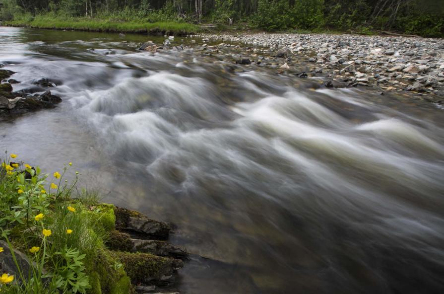
The OHWM delineates the bed from the uplands. The bed generally consists of silt, sand, gravel, or larger substrate, is generally covered in water, and scours annually preventing vegetation growth. The uplands begin where the bed ends, and where the soil and non-aquatic vegetation begin. See below an illustration of the submerged lands, OHWM, and uplands along a river.
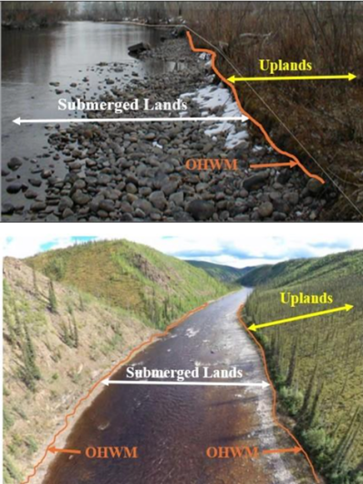
The submerged lands of navigable waters include the bed up to the ordinary high-water mark (OHWM) of the banks of rivers and lakes, and tidal waters extending up to the mean high-tide line. - Who owns submerged lands and why might the public care?
Navigable waters: Under federal law, the State owns the unreserved, unwithdrawn submerged lands beneath waters that were navigable as of the date of statehood.10
Pre-statehood withdrawals: The federal government can retain ownership of submerged lands, including those beneath navigable waters, if those lands were clearly and specifically reserved or withdrawn before statehood.
Non-navigable waters: The upland or riparian landowner adjacent to non-navigable waters owns the submerged lands to the middle of the waterbody.
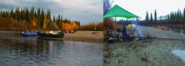
Submerged lands are not always submerged under water; remember that submerged lands are those lands that lie below the OHWM. That means during part of the year when water levels are low to average, rivers and lakes will often contain exposed gravel bars or sandy beaches that are above the edge or surface of the water. Those areas are attractive to the recreational public, and they need to know what rules apply to those lands. The photos below illustrate recreational activities occurring on submerged lands below the OHWM.
10 https://constitution.congress.gov/browse/essay/artIV-S3-C1-5/ALDE_00013712/
- Can the public use navigable public waters?
- Article VIII, Section 3 of the Alaska Constitution states: Wherever occurring in their natural state, fish, wildlife, and waters are reserved for common use by the people.11
- Article VIII, Section 14 of the Alaska Constitution states: Free access to the navigable or public waters of the state, as defined by the legislature, shall not be denied any citizen of the United States or resident of the state, except that the legislature may by general law regulate and limit such access for other beneficial uses or public purposes.12
11 https://ltgov.alaska.gov/information/alaskas-constitution/
12 https://ltgov.alaska.gov/information/alaskas-constitution/
- Does the BLM make navigability determinations for any waterbody?
- The BLM only makes navigability determinations if there’s a federal interest in determining who holds title to the submerged lands.
- There IS federal interest in determining navigability for title purposes in the submerged lands when the uplands or riparian are owned by the federal government. If the federal government owns the uplands of a non-navigable waterbody, then they would own the submerged lands to center of that waterbody. For navigable waters, the State owns the submerged lands regardless of the upland owner unless a valid reservation or withdrawal exists.
- There is NOT federal interest in determining navigability for title purposes in the submerged lands of any waterbody if the uplands have been conveyed out of federal ownership. If the federal government does not own the uplands the question of navigability and ownership of the submerged lands must be determined by the landowner, the State, or the courts.
- Why does BLM make navigability findings?
Public land laws require that the BLM make navigability findings prior to conveying or transferring lands out of Federal ownership. Since 1978, BLM Alaska has prepared administrative navigability findings mostly in support of land transfer actions under the Alaska Native Claims Settlement Act (ANCSA), the Alaska Statehood Act, the 1906 Native Allotment Act, and more recently, the Dingell Act.
The Secretary of the Interior has been granted discretionary authority by Section 315 of the Federal Land Policy and Management Act of 1976 (43 U.S.C. 1745) to issue recordable disclaimers of interest. This process allows the BLM to make navigability findings in response to recordable disclaimer of interest applications for submerged lands beneath navigable waters. These submerged lands are on lands still in federal ownership and not part of the conveyance process described above.
Identifying navigable waters within the state removes the cloud of ownership of submerged lands beneath navigable waters. This allows the public to understand whose rules apply to those submerged lands. With the cloud of ownership removed from navigable waters, the State can administer submerged lands beneath navigable waters with confidence.
- How does navigability affect the application of the Alaska National Interest Lands Conservation Act Title VIII subsistence priority?
The ownership of submerged lands generally does not control where the subsistence priority under ANILCA applies. This is because the priority applies according to the federal reserved water rights doctrine. Under this doctrine, the United States hold reserved water rights necessary to accomplish the purposes of some of the lands it owns. These rights exist in a waterway regardless of who owns the submerged lands under the waterway.
There could be BLM public domain lands outside of these areas over which the federal subsistence priority was assumed to apply because the relevant waterbody’s navigability had not been adjudicated. In this case, an RDI regarding such a waterway would merely clarify the priority did not apply, since an RDI does not operate to transfer ownership, but rather only clarify ownership.