
Route 66 Historic Back Country Byway Map
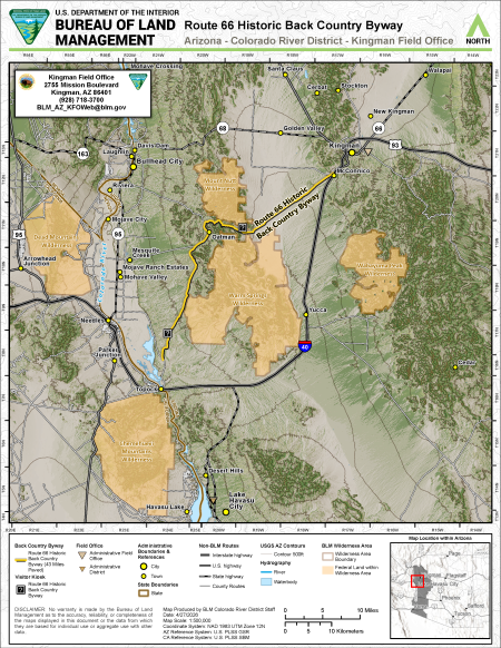
This free, downloadable georeferenced PDF map shows the Route 66 Historic Back Country Byway in western Arizona, managed by the Bureau of Land Management (BLM) Colorado River District's Kingman Field Office.
The Route 66 Historic Back Country Byway is a 42-mile paved scenic drive along one of the most well-preserved stretches of Historic Route 66 in Arizona, passing through the Black Mountains and the historic gold mining town of Oatman. The byway is shown as a yellow line on the map and runs between Kingman and Topock, Arizona, near the California border. Two visitor kiosks are shown along the byway route.
Four BLM wilderness areas are shown on the map in gold/tan. Wilderness area boundaries are shown with a distinct boundary line. The wilderness areas shown are the Chemehuevi Mountains Wilderness and Dead Mountains Wilderness in California as well as the Mount Nutt Wilderness, and Wabayuma Peak Wilderness, and Warm Springs Wilderness in Arizona.
The Kingman Field Office administrative boundary and the Colorado River District administrative boundary are shown on the map. Cities shown include Kingman, Bullhead City, Laughlin (Nevada), Lake Havasu City, and Needles (California). Towns shown include Arrowhead Junction, Cedar, Cerbat, Davis Dam, Desert Hills, Golden Valley, Havasu Lake, McConnico, Mesquite Creek, Mohave City, Mohave Crossing, Mohave Ranch Estates, Mohave Valley, Mojave Ranch Estates, New Kingman, Oatman, Parker Junction, Riviera, Santa Claus, Stockton, Topock, Walapai, and Yucca.
State boundaries between Arizona, California, and Nevada are shown. An inset map in the lower right shows the location of the map area within Arizona.
Interstate highways shown include Interstate 40 and Interstate 15. U.S. highways shown include US Route 93 and US Route 95. State highways shown include State Route 66, State Route 68, and State Route 163. County routes are also shown.
The Colorado River is shown running along the western edge of the map, forming the border between Arizona and California. Waterbodies shown include Lake Havasu.
This map was produced by Colorado River District staff on April 27, 2026. The scale is 1:500,000 using the NAD 1983 UTM Zone 12N coordinate system. USGS Arizona contour lines are shown at 500-foot intervals. The Arizona Reference System is U.S. PLSS GSR and the California Reference System is U.S. PLSS SBM.
For questions, contact the Kingman Field Office at 2755 Mission Boulevard, Kingman, AZ 86401, by phone at 928-718-3700, or by email at [email protected].
No warranty is made by the Bureau of Land Management as to the accuracy, reliability, or completeness of the maps displayed in this document or the data from which they are based for individual use or aggregate use with other data.