
Nevada Byways
Back Country Byways are a wonderful way to explore some of Nevada’s more remote landscapes by car, truck, jeep or motorcycle.
Remember, Nevada is VERY remote. Large portions of the state do not have cell service and gas stations are few and far between. Here are some tips to keep you safe out there:
- Gas up! Make sure you have enough fuel to get you where you want to go AND back.
- Maps! Don’t plan on signs telling you where to go. Carry a good map such as an “atlas and gazetteer” or similar. Better yet, there are many apps that allow you to download maps onto your phone in town and use them without cell service. Examples are “Avenza PDF Maps” and “OnX Offroad” among others. These both require a fee but other free options exist. Remember, even with a downloaded map, phones need to be charged to work! A dead phone is no help.
- Be known! Let a friend or family member know exactly where you are going and when you plan on getting back.
- Tools! Help is unlikely to be found in many remote parts of Nevada’s BLM lands. Carry what you need to help yourself including some basic tools, fluid for your vehicle and a shovel in case you get stuck in sand or snow.
- Spare Tire! Check your spare. Roads in Nevada often have sharp rocks. Flats are common. If possible, carry a full-sized spare tire.
- Food and Water! Think about what you might need to take care of yourself in case your vehicle is stuck or broken down. A day trip can easily turn into an overnight if trouble strikes.
- Clothes and Shoes! Bring some clothes and shoes appropriate for the weather in case you have to walk to find help.
- Weather! Many of the back country roads in Nevada can become completely impassable when wet. Plan ahead! Check the weather!
- Slow Down! Wide open expanses might tempt you to up the pace a little. Remember, you are a long way from help and the consequences of an accident are high. Slow down and stay safe!
Please refer to byway type descriptions via this document to understand which of Nevada’s Back Country Byways your vehicle is appropriate for.
Bitter Springs Back Country Byway - Type II
Bitter Springs Back Country Byway offers a drive with many rock formations, like the Muddy Mountains and colorful sandstone for sightseeing. Along the byway, visit abandoned borax mines and evidence of rivers that have long since dried up. Bitter Springs is close to many entertaining and informational areas such as Las Vegas, the Valley of Fire State Park, the Moapa Indian Reservation, Lake Mead National Recreation Area, and Hoover Dam. High-clearance vehicles are required and four-wheel drive vehicles are recommended. Allow 2 to 4 hours to enjoy the 28 miles.
For more information please visit the Bitter Springs Back Country Byway or contact: The Las Vegas Field Office
California Trail Back Country Byway - Type I
The California Trail Back Country Byway parallels a portion of the California National Historic Trail, which saw over 250,000 immigrants make their way from Independence, Missouri to California over 150 years ago. The byway is rich with such historical treasures as wagon wheel ruts and remains of historic structures. Access the byway near the turnoff to Thousand Springs, a favorite watering hole of the immigrants that passed through the area. Enjoy primitive camping, hiking, backpacking, and mountain biking on BLM lands. Whatever you do, you’re sure to enjoy your experience as you travel a priceless piece of history on the California Trail Back Country Byway. Allow 3+ hours to enjoy these 96 miles.
For more information please visit the California Trail Back Country Byway or contact: The Wells Field Office
Gold Butte Back Country Byway - Type II
The Gold Butte Back Country Byway travels across 62 miles of Nevada desert. The town of Gold Butte stands as an old mining town established in the early 1900s where precious metals such as gold, copper, zinc, and lead were mined. The byway offers chances to see petroglyphs, colorful sandstone, and great formations like the Muddy Mountains or the Virgin Mountains along the way. The byway is near the Lake Mead National Recreation Area, which makes it a fun location for the whole family. Discover all the exciting places to visit within just a few hours of driving distance. Stop at Las Vegas, Hoover Dam, Mesquite, or the Valley of Fire State Park. Portions of this 62-mile byway may require a high-clearance type vehicle. Allow 4 to 5 hours to enjoy this trail.
For more information please visit the Gold Butte Back Country Byway or contact: The Las Vegas Field Office
Fort Churchill to Wellington Back Country Byway - Type I & Type II
The Fort Churchill to Wellington Back Country Byway spans 67 miles beginning in Fort Churchill and ending in Wellington. Fort Churchill was named after Inspector General Sylvester Churchill of the US Army upon its construction in the 1860s. It was built in order to protect the Pony Express riders and settlers against the Indians. In 1957 Fort Churchill became part of the Nevada State Park system. Have fun exploring the area and learning about the significance of Fort Churchill. Portions of this 67 mile byway may require a high-clearance type vehicle. Allow 4 to 5 hours to enjoy this trail.
For more information please visit the Fort Churchill to Wellington Back Country Byway or contact: The Sierra Front Field Office
Lovelock Cave Back Country Byway - Type I & Type II
As you travel the Lovelock Cave Back Country Byway, see what remains of Lake Lahontan that dried up over 1,400 years ago. Lovelock Cave has yielded 2,000-year-old artifacts, such as duck decoys, baskets and textiles, many of which are displayed in museums throughout the United States. Come and see why Lovelock Cave is known as the cradle of Great Basin archaeology. Look at the old interpretive signs on the cave walls that span 150 feet long and 35 feet wide, or enjoy a self-guided nature trail hike to explore the area. Portions of this 20 mile byway may require a high-clearance type vehicle. Allow 2 to 3 hours to enjoy this byway.
For more information please visit the Lovelock Cave Back Country Byway or contact: The Humboldt Field Office
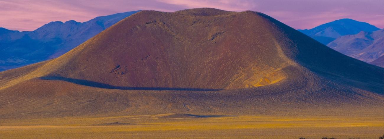
Lunar Crater Back Country Byway - Type II
The Lunar Crater Back Country Byway is 24 miles long. It has been a National Natural Landmark since its designation in 1973. Along this bumpy and unpaved byway, explore a volcanic field complete with cinder cones and basalt flows similar to the findings on the moon. Easy Chair Crater is one of the first visible craters upon entering the byway. Continuing further you’ll pass through several rock formations and reach Lunar Crater. From Lunar Crater, see 20 other extinct volcanoes close by. Along with exploring the unique formations, enjoy the wildflowers and fantastic wildlife along the way. Portions of this byway may require a high-clearance type vehicle. Allow 1 to 2 hours to enjoy this byway.
For more information please visit the Lunar Crater Back Country Byway or contact: The Tonopah Field Office
Mt. Wilson Back Country Byway - Type II
Mount Wilson Back Country Byway extends around 66 miles of the Wilson Range. The gravel road winds through volcanic caldera now overgrown with pinyons and junipers along the skirts of the range. Towards the peaks of the range, aspens and ponderosa pines grow profusely. Trek through the byway, crossing wide basins and passing through narrow canyons. Explore historical cabins or visit a pioneer cemetery. Stop at the historical Pioche mining town as you work your way through the Wilson Range and take time to discover the many species of wildlife. Portions of this 64-mile byway may require a high-clearance type vehicle. Allow 2 to 4 hours to enjoy this byway.
For more information please visit the Mt. Wilson Back Country Byway or contact: The Caliente Field Office
Red Rock Canyon Back Country Byway - Type I
Red Rock Canyon Back Country Byway spans for 13 miles across a paved loop through the Red Rock Canyon National Conservation Area. Stop at several pullouts along the byway and enjoy the spectacular colors in the rock formations. Driving the byway during the warmer months offers a better view and more time in the day to drive the byway. Red Rock Canyon has many outdoor activities to enjoy. Go picnicking, hiking, backpacking, or rock climbing, observe wildlife, stop in at the Visitors Center, or take a trip to Las Vegas, only a few miles away. This byway is 13 miles long, allow 1 hour to enjoy it.
For more information please visit the Red Rock Canyon Back Country Byway or contact: The Red Rock-Sloan Field Office