
Plan Your Visit to Table Rocks
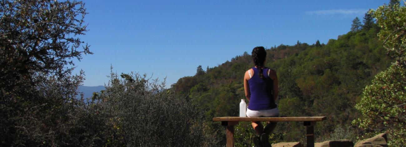
The Table Rocks trails are some of the most highly used trails in the Rogue Valley—almost 60,000 people hike the trails to the top each year. You could be one of hundreds of hikers enjoying the wildflowers and scenic vistas on a beautiful spring day, or you could be the lone hiker on a cold, foggy winter day.
Some people like to linger and take their time getting to the top, watching for birds and identifying wildflowers on the way, while others run the trail and focus on getting a workout.
During the spring months, BLM Rangers lead large school groups on guided hikes Tuesday through Fridays, stopping often along the trail. To encounter fewer people and school groups, consider hiking in the early morning or early afternoon on weekdays.
- Help Protect the Table Rocks
- Dogs are not allowed at the Table Rocks. To prevent disturbance to ground-nesting birds and other animals, please leave Fido at home.
- The Table Rocks are for hiking only—no horses, bikes, or off-highway vehicles.
- Leave the flowers for others to enjoy! A picked flower cannot reproduce.
- Do not disturb markers, signs, or fencing. These are in place to prevent trampling, or are part of ongoing study plots.
- Avoid walking or wading in the vernal pools. The soft soil near the pools is home to many fragile and endangered species and is especially sensitive to trampling.
- Please do not stack rocks on the top. It causes damage to sensitive soils.
- Do not cut switchbacks or use shortcuts, this causes erosion.
- Stay on the existing trails, even if they are muddy. This prevents excess erosion and trampling of rare plants.
- Carry out what you carry in. There are limited trach facilities.
- Use the weed station at the trailhead before and after your hike to prevent the spread of noxious weeds.
- Trail Etiquette
Please respect the Table Rocks' unique resources and be considerate of other people you encounter on the trail.
- Treat all trail users with respect and courtesy regardless of their speed or skill level.
- Anticipate other trail users around corners or in blind spots.
- Downhill traffic yields to uphill traffic and faster users yield to slower users.
- If you enjoy taking your time on the trail, move to the side to allow faster hikers and runners to pass you.
- If you stop, find a safe place where you can pull off from the trail so you aren't blocking traffic in either direction.
- If you’re a fast hiker or runner, slow down when you encounter school groups to give them a chance to move aside.
- Just the Facts
Upper Table Rock, trail to top
- 2.5 miles round trip
- Elevation gain: 736'
- Difficulty: Easy to moderate with some steep sections
- Estimated hours round trip: 2-3
- Trail surfacing: Gravel first mile; natural surface last 0.25 mile
- Additional trail miles and conditions on top: 0.75-mile loop around rim—natural surface
- Description: Expect to see more people on this trail than Lower Table Rock. During wet conditions, all trails will be muddy and slick.
- Drinking water available? NO
Lower Table Rock, trail to top
- 2.8 miles round trip
- Elevation gain: 809'
- Difficulty: Moderate with some steep sections
- Estimated hours round trip: 3-4
- Trail surfacing: Gravel
- Additional trail miles and conditions on top: 1.5 miles RT on airstrip to south viewpoint—natural surface
- Description: Interpretive signs. Fewer people, less muddy than Upper Table Rock trail
- Drinking water available? NO
Lower Table Rock, Oak Savannah Trail
- 0.5 miles round trip
- Elevation gain: 80'
- Difficulty: Easy
- Estimated hours round trip: 0.5
- Trail surfacing: Gravel
- Additional trail miles and conditions on top: N/A
- Description: Interpretive signs.
- Drinking water available? NO
- Be Aware
Please be aware of the following considerations before hiking Table Rocks.
Rattlesnakes
Many consider themselves lucky to see a rattlesnake. If the opportunity arrives, remain calm, have a good look if you can, and ease your way around it. The rattlesnake is rarely aggressive and not as dangerous as many of us have been led to believe.
Ticks
Ticks commonly attach themselves to clothing or skin. As you hike, take the time to stop and check yourself and others in your party for ticks. Staying on trails and away from shrubs and tall grasses will reduce your risk of encountering ticks. Some ticks carry Lyme disease. It is important, if bitten, to carefully remove the tick and watch for symptoms.
See the Centers for Disease Control and Prevention (CDC) website for excellent information about Lyme disease.
Dehydration
Dehydration can be a concern while hiking. There is no water on the Table Rocks and shade is limited during the extreme summer conditions. Please come prepared and drink lots of water throughout your hike.
Poison Oak
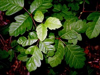
“Leaves of Three Let It Be!” Familiarize yourself with this plant. It can grow as a shrub, vine, or can be a single stick. Look for the shiny red-green leaves that emerge in the spring. It grows all along the trail and is even on top! Staying on the trails can help you avoid contact with this plant. Wearing long pants, long sleeved shirts, and close-toed shoes helps. If you think you may have touched it, be sure to wash with cool, soapy water as soon as possible.
High Cliffs
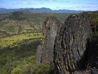
Beware of the dangers inherent in the high cliffs; stand back from the edge. Rocks are loose, crumbly, and can be slick when wet. Cliffs are not suitable for rock climbing.
Facilities
Vault toilets are available at the Table Rocks parking area. There are no restroom facilities available at the top.
- Driving Directions and Trail Maps
Upper Table Rock: From Interstate 5, take Exit #33 at Central Point. Head east on East Pine Street for 1 mile. Turn north (left) on Table Rock Road. Drive 5.3 miles to Modoc Road and turn north (right). The trailhead is located another 1.5 miles on the left.
Lower Table Rock: From Interstate 5, take Exit #33 at Central Point. Head east on East Pine Street for 1 mile. Turn north (left) on Table Rock Road. Drive 8 miles to Wheeler Road and turn west (left). The trailhead is located another 0.5 mile on the left.
Table Rocks Trails Map by Bureau of Land Management - Oregon | Avenza Maps