Alaska Land Transfer Program Phrases You May Hear Us Use
ANCSA
ANCSA – the Alaska Native Claims Settlement Act of 1971.
ANCSA is a landmark federal law that resolved longstanding Alaska Native land claims and created a new framework for land ownership and economic development in Alaska. Instead of establishing reservations, the law created 12 regional and more than 200 village Alaska Native corporations and authorized the conveyance of 44 million acres of land and nearly $1 billion to these corporations.
Much of the work of BLM Alaska’s Land Transfer Program supports the implementation of ANCSA. This includes surveying land, resolving boundary questions, creating legal descriptions, and transferring federal land to Alaska Native corporations so it can be owned and managed locally.
More than five decades after it was signed into law, ANCSA continues to shape land ownership across the state and guide our efforts to complete the remaining land conveyances authorized by the act.
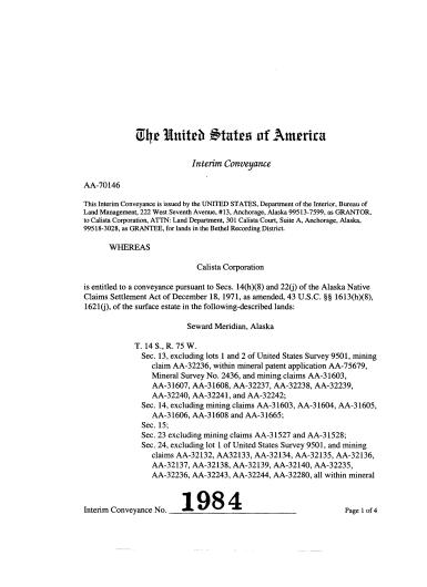
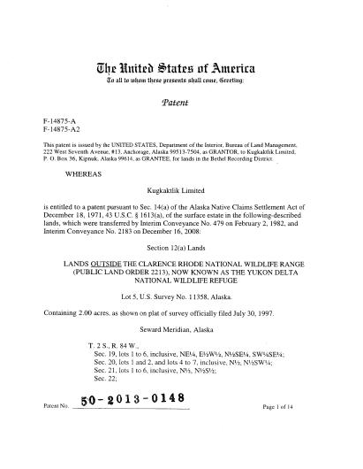
Interim Conveyance (IC)
An Interim Conveyance (IC) is a legal document used during the implementation of the Alaska Native Claims Settlement Act (ANCSA) to transfer title of land to Alaska Native corporations before a final survey has been completed.
Because much of Alaska is remote and had not been fully surveyed when ANCSA was passed in 1971, Congress authorized interim conveyances to help move land transfers forward while surveys were still pending. An IC allows Alaska Native corporations to receive and manage their land sooner, even though the exact boundaries will later be confirmed through an official cadastral survey. An IC transfers all rights, title, and interests to the Alaska Native corporation.
Once the survey is completed and the boundaries are finalized, the interim conveyance is replaced by a patent, which is the final document that permanently confirms the land title and legal description.
Interim conveyances have played an important role in keeping the Alaska Land Transfer Program moving forward, allowing millions of acres to be conveyed while survey and mapping work continues across the state.
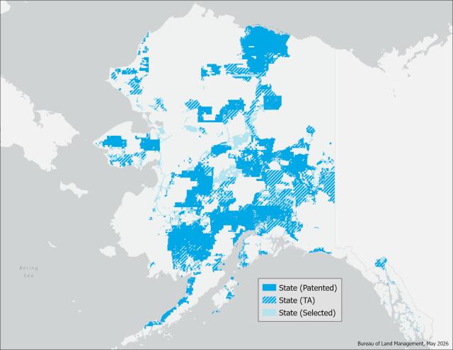
Alaska Statehood Act
This week's phrase is the Alaska Statehood Act – the federal law that paved the way for Alaska to become the 49th state in 1959.
The 1959 Alaska Statehood Act authorized the transfer of approximately 105 million acres of federal land to the State of Alaska. With the latest conveyance of lands north of the Yukon River, the BLM has fulfilled more than 96% of the state’s entitlement under the Alaska Statehood Act
BLM Alaska’s Land Transfer Program plays a key role in implementing the Statehood Act. This work includes surveying lands, resolving title and boundary issues, and conveying federal lands to the State of Alaska to fulfill its land entitlements. The State of Alaska has approximately 3.8 million acres remaining for its entitlement.
Decades after statehood, this work continues today as we complete remaining conveyances and ensure that the promises of the Alaska Statehood Act are fully realized for the benefit of Alaskans.
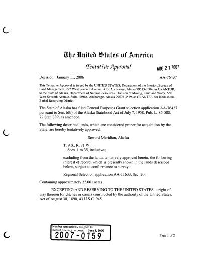
Tentative Approval (TA)
A Tentative Approval is similar to an Interim Conveyance except that where an Interim Conveyance transfers all rights, title, and interests from the United States to an Alaska Native Corporation under the Alaska Native Claims Settlement Act (ANCSA), the Tentative Approvals transfers all rights, title, and interests from the United States to the State of Alaska. Before a Tentative Approval is issued, BLM land law examiners must complete the adjudication of the State of Alaska’s application and selected lands to ensure the issuance of the Tentative Approval meets all statutory and regulatory requirements under the Alaska Statehood Act of 1958. Once the land is surveyed, a confirmatory patent can be issued.
At BLM Alaska, Tentative Approval represents meaningful progress for the State of Alaska Land Transfer Program, bringing the United States closer in fulfilling the State of Alaska's entitlements under the Act of 1958.
Adjudication
Adjudication is the process of reviewing and evaluating land applications and claims to ensure they meet the requirements of public land laws and regulations.
At BLM Alaska, the professionals who perform this work are called land law examiners. These specialists carefully research land status and ownership records on millions of acres to determine whether an application is valid and what land is available for transfer. Their work helps ensure that land conveyances to the State of Alaska, Alaska Native corporations, and individual applicants are accurate, lawful, and properly documented.
Land law examiners review deeds and historical land records, verify legal descriptions, resolve discrepancies in property information, and prepare detailed reports that support official decisions. They also work closely with cadastral surveyors, legal staff, and other federal and state agencies to make sure boundaries, land status, and legal requirements all align before a conveyance moves forward.
In addition to research and analysis, land law examiners frequently assist the public by answering questions and helping applicants navigate specialized programs, like the Alaska Native Vietnam-era Veterans Land Allotment Program.
Through careful review and collaboration, adjudication ensures that each land transfer is based on accurate records, sound legal analysis, and a clear understanding of Alaska’s complex land history.

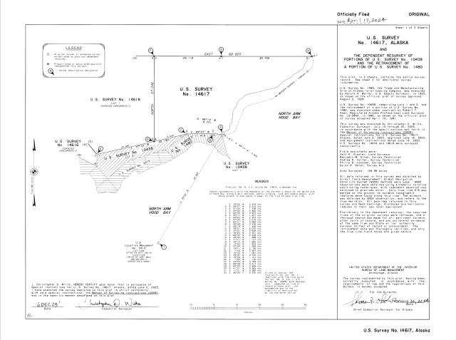
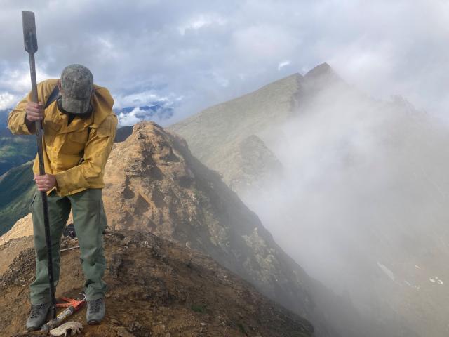
Cadastral Survey
A cadastral survey is how we establish land boundaries on the ground and in our records. It’s the backbone of accurate land transfer and imperative to the transfer of a clear title. It also provides certainty of boundary and corner locations.
In Alaska, BLM cadastral surveyors do much more than draw lines on a map. They travel to some of the most remote places in the state, often by small aircraft, boat, snowmachine and other modes of transportation, to locate historic survey markers, measure land using precise instruments and GPS technology, and place new monuments that mark legal property boundaries on the ground. Their work helps define township, section, and property lines across millions of acres of federal land and ensures that land conveyed to the State of Alaska, Alaska Native corporations, and private owners is accurately described and legally defensible.
After fieldwork is complete, surveyors return to the office to compile their measurements, field notes, and historical research into official plats and survey records. These documents undergo careful technical review before being finalized and entered into the public land record.
This detailed work ensures that land ownership in Alaska is clearly defined, legally documented, and available to support everything from land transfers and infrastructure projects to community planning and resource management...and where to put your fence or plant that tree. These surveys are also the framework for Geographic Information Systems (GIS) mapping platforms used by a myriad of federal and state agencies, as well as private companies and the general public for land and resource management.
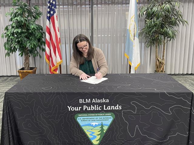
Certificate of Allotment (CoA)
A Certificate of Allotment (CoA) is the official document that transfers title for a Native allotment to an individual Alaska Native. It represents a key milestone in the Alaska Native Allotment process, formally recognizing an individual’s ownership of land.
Before a CoA is issued, the parcel must be carefully reviewed and surveyed to confirm its location and boundaries. Once the allotment is finalized, the certificate is prepared as the legal document that conveys the land title.
At BLM Alaska, leadership proudly signs each land transfer by hand, marking the final step in transferring the land and officially placing it into the ownership of the Alaska Native allottee. The certificate becomes part of the permanent land record and represents an important moment for the individual, their family, and their connection to the land.
The Alaska Native Allotment Act of 1906, the Alaska Native Claims Settlement Act (ANCSA), Section 905 of the Alaska National Interest Lands Conservation Act (ANILCA), the Alaska Native Vietnam Veterans Allotment Act of 1998 and the 2019 Alaska Native Vietnam-era veterans land allotment section of the John D. Dingell, Jr., Conservation, Management, and Recreation Act (Public Law 116-9, Sec. 1119) are all important legislation that has shaped BLM Alaska's Alaska Native Allotment Program.
Decision
In the Alaska Land Transfer Program, a Decision is a formal written document signed by an authorized official that explains the findings and determination on a land application or claim.
Before a decision is issued, BLM specialists review historical records, analyze land status, coordinate surveys when needed, and ensure the application meets the legal requirements of the governing law like the Alaska Native Claims Settlement Act (ANCSA) or other land transfer authorities.
The decision document lays out the facts of the case, the applicable laws and regulations, and the official determination, such as approving, partially approving, or denying a claim. It also explains the next steps in the process and provides information about appeal rights.
Each decision represents an important step forward in the Alaska Land Transfer Program, helping move land applications toward final resolution and ensuring the process is transparent, documented, and legally sound.

Easement
An easement is a legal right that allows someone to use a portion of another person’s land for a specific purpose, without owning the land itself.
In BLM Alaska, easements are often established to ensure important access across lands that have been conveyed to new owners. These rights may allow for travel corridors, trails, roads, utilities, or access to public lands and waterways.
One example unique to Alaska is a 17(b) easement. These are rights reserved to the United States and may also be reserved to and from communities, airports, docks, marine coastline, groups of private holdings sufficient in number to constitute public use and government facilities. They take the form of 60-foot-wide roads, 25- and 50-foot trails, and one-acre sites for short-term uses. These rights are reserved when the BLM conveys land to an Alaska Native corporation under the Alaska Native Claims Settlement Act (ANCSA).
As part of the Alaska Land Transfer Program, BLM works to identify, document, and reserve necessary easements during the land conveyance process. Clearly defined easements help balance private land ownership with long-term access needs, supporting transportation, subsistence access, utilities, and recreation across Alaska’s vast and often remote landscape.

Land Patent
A Land Patent is the official document that transfers legal title to public land from the federal government to another party. It is the final and permanent conveyance document, marking the completion of the land transfer process.
Before a patent can be issued, a parcel typically goes through several steps, including land selection, adjudication, survey, and legal review. These steps ensure the land is accurately described, properly documented, and eligible for transfer under the applicable law, such as the Alaska Native Claims Settlement Act or Statehood Act.
Once all requirements are met, the land patent is signed and recorded as part of the permanent public land record. At that point, ownership of the parcel is officially and legally transferred to the recipient like the State of Alaska, an Alaska Native corporation, or an individual allottee.
For the Alaska Land Transfer Program, issuing a patent represents a major milestone in the life of a parcel and the completion of years of careful research, survey work, and legal review.
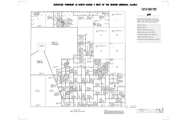
Master Title Plat
A Master Title Plat (MTP) is an official land status map that shows the current ownership and legal interests affecting a parcel of federal land. It provides a visual snapshot of who owns what and highlights important details such as surveys, land selections, withdrawals, and rights-of-way.
Before an MTP is finalized, land information is carefully compiled from surveys, historical records, and legal documents. Each action affecting the land, such as selections under the Alaska Native Claims Settlement Act, is reviewed and plotted to ensure accuracy and completeness.
Once completed, the MTP becomes part of the official public record and is used by land managers, surveyors, and the public to understand land ownership and status.
For the Alaska Land Transfer Program, the Master Title Plat is an essential tool. It brings together complex land information into a clear, usable format, supports decision-making, and helps ensure that land transfers are accurate, transparent, and well documented.
Metes and Bounds
Metes and bounds descriptions are used to describe the boundaries of a parcel of land using distances, directions, and natural features. It relies on physical features, landmarks, and measurements to define property lines, often starting from a known point and following a sequence of courses around the parcel until returning to the point of beginning.
Before current survey systems were widely adopted, metes and bounds descriptions were commonly used to define land ownership. These descriptions might reference natural features such as rivers, trees, or ridgelines, along with compass bearings and measured distances. Over time, some of these landmarks may change or disappear, which can make older descriptions more difficult to interpret.
Today, metes and bounds descriptions are still used in certain cases, especially for irregularly shaped parcels or in areas where the Public Land Survey System does not apply. Surveyors carefully interpret these descriptions and may rely on historical records and field evidence to accurately locate property boundaries.
For the Alaska Land Transfer Program, understanding metes and bounds descriptions is important when working with legacy land records. It helps ensure that boundaries are correctly identified and that land status and ownership are accurately documented.