
Lower Deschutes Maps
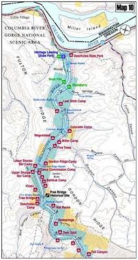
How to Use the Maps
The maps and map logs read from bottom to top on each page, as if one were in a boat facing downriver. Upriver is towards the bottom of the map/log. Downriver is towards the top of the map/log.
The log files also read from bottom to top, with downriver features being towards the top of the page, and upriver features being towards the bottom of the page. The leftmost column features the river mile marker at which the location/feature is located. The rightmost column contains a text overview of the location/feature.