
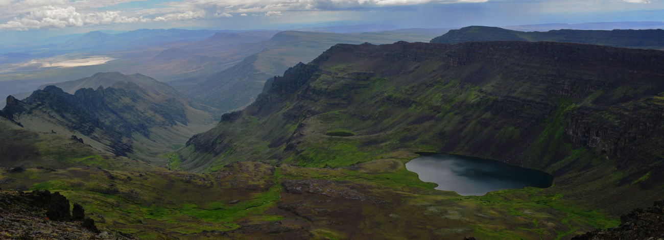
Steens Mountain Wilderness
The United States Congress designated the Steens Mountain Wilderness in 2000 and it now has over 170,200 acres. All of this wilderness is located in Oregon and is managed by the Bureau of Land Management. Steens Mountain is located in Oregon's high desert is one of the crown jewels of the state's wildlands. It is some of the wildest and most remote land left in Oregon.
Opportunities for recreation on Steens Mountain are as plentiful as they are widespread. Popular activities include camping, picnicking, sightseeing, and exploring the open country on foot and horseback. Hiking is available in all areas and trailheads exist near Page Springs and South Steens Campgrounds, as well as Wildhorse Overlook and Pike Creek. Visitors photograph landscapes, wildlife and wildflowers, and catch redband trout in the Donner und Blitzen River. Others enjoy hunting for wild game and visiting special places, cross-country skiing, and snowshoeing.
- Directions
From Burns, take State Highway 78 southeast for approximately 2 miles. Then turn right onto State Highway 205 and travel south for 60 miles to Frenchglen. Just past Frenchglen, turn left onto the Steens Mountain Loop Road.
- Know Before You Go
Considerations for backcountry travel in the Steens Mountain Wilderness include:
- Some areas have limited water sources—carry enough water and food to last your entire trip, and do not drink from untested water sources.
- Ticks, mosquitoes, and rattlesnakes in certain areas during spring and summer.
- Weather conditions—the mountain's high elevation can cause rapid temperature changes. Blustery, 100-degree days are common and snow can fall year-round. Be prepared for sudden lightning storms, snow, rain, and high winds. Long distances between services—including gas stations, phones, and cell phone reception. Let someone at home know where you plan to go and when you plan to return. Phone service should not be relied on for emergency communication. Always start your trip with a full tank of fuel and call ahead for current information about fuel availability in the Steens Mountain area. Fuel may be available in the towns of Fields, Frenchglen, Crane, or the Narrows.
- Rough terrain—deep canyons and rocky slopes are a natural part of the rugged mountain territory. Elevation can change from less than 4,000 feet to over 9,000 feet in just a few miles. We recommend high clearance or 4x4 vehicles for primitive roads, including the steep and rocky portion of the Steens Mountain Loop Road near South Steens Campground. The rest of the Steens Mountain Loop Road can accommodate passenger cars at lower speeds. High quality tires are a must for all vehicles, even when traveling on maintained routes.
- Livestock and wildlife on roadways—much of southeast Oregon is open range. Be alert, drive with caution, and plan to share roadways with cattle, deer, elk, antelope, wild horses, and rabbits!
- Getting lost—the remote nature and vast landscape of the Steens Mountain area may leave even the most experienced traveler directionally confused or just plain lost. Traveling with a current map of the area is essential! Don't hesitate to talk to locals—area landowners and Federal employees are generally visible in the Steens Mountain area. We welcome your visit and have information to help you.
- The Steens Mountain Cooperative Management and Protection Area contains a mixture of public and private lands and specially designated areas where particular regulations may apply. Obey road closure signs and stay on designated open routes—driving off road is prohibited. Please respect landowners in the area and always get permission to go onto private property.
Visitors can help in protecting this fragile ecosystem by adequately planning and by arriving prepared! Knowledge of the area, weather, terrain, and common sense can help to ensure you have a safe, fun, and memorable trip to the wild. Trail junctions are generally unsigned, so you should carry a map and a compass. And always be sure to bring your ten essentials!
- Management Background
On October 30, 2000, the Steens Mountain Cooperative Management and Protection Act of 2000, providing additional protection to approximately 900,000 acres of Federal land in southeastern Oregon, was signed into law. The Act is a culmination of a cooperative effort between Oregon's Congressional delegation, Oregon's Governor, and the Secretary of the Interior to forge legislation that will provide long-term protection to the cultural, economic, ecological, and social health of the Steens Mountain Area.
The Act designated the Steens Mountain Cooperative Management and Protection Area to be managed by the Bureau of Land Management (BLM) with the advice of the Steens Mountain Advisory Council to conserve, protect, and manage the long-term ecological integrity of the Steens Mountain for future and present generations. Within this area, cooperative and innovative management projects are maintained and enhanced between the BLM, private landowners, tribes, and other public interests. Sustainable grazing and recreational use, including fishing and hunting, continue where consistent with the purpose of the Act.
A land exchange provision blocked up nearly 100,000 acres of livestock-free wilderness within the designated 170,202-acre Steens Mountain Wilderness. This land, at the top of the Steens Mountain, is the most sensitive to disturbance and will be managed to safeguard the pristine environment.
The Act also designated three new Wild and Scenic Rivers — Wildhorse Creek, Little Wildhorse Creek and Kiger Creek — and adds two new segments — Ankle Creek and Mud Creek — to the existing Donner und Blitzen Wild and Scenic River. Also, the first ever Redband Trout Reserve was created to improve stream health and fish habitat.
Approximately 900,000 acres are designated off limits to mineral and geothermal extraction.
- Planning
In August 2005, the BLM finalized the Andrews Management Unit/Steens Mountain Cooperative Management and Protection Area Resource Management Plan.
The Andrews Management Unit (AMU) and Steens Mountain Cooperative Management and Protection Area (CMPA) Resource Management Plans (RMP) provide a framework and direction for efficient on-the-ground management of 1.7 million acres of public land lying primarily within the Andrews Field Office of the Burns District of the Bureau of Land Management (BLM). These two planning areas encompass approximately half of sparsely populated Southern Harney County, Oregon. In the heart of the region is Steens Mountain, a 70-mile long fault block reaching over 9,000 feet elevation and containing spectacular, deep, glacier-formed gorges, Steens Mountain Wilderness Area (which includes a 97,000-acre no grazing area), and designated Wild and Scenic Rivers.
The majority of Steens Mountain is within the CMPA, 428,000 acres of a special management region created by the Steens Mountain Cooperative Management and Protection Act (Steens Act) of 2000). This legislation stipulated a management plan be written for the CMPA, and the CMPA RMP is a result of that mandate. A primary goal of the comprehensive plan for the CMPA is to develop management practices that promote long-term sustainability of a healthy and productive landscape and achieve the purpose of the CMPA which "…is to conserve, protect, and manage the long-term ecological integrity of Steens Mountain for future and present generations."
The Wild and Scenic Rivers Act of 1968, Section 3(d)(1) also charges the Federal agency responsible for the administration of each component of the National Wild and Scenic Rivers System to prepare a comprehensive management plan providing for the protection of river values. The Steens Act designated three new Wild and Scenic Rivers and three additional river segments for the existing Donner und Blitzen Wild and Scenic Rivers System. The Wild and Scenic Rivers Plan, combined with a plan for Steens Mountain Wilderness, is designated as Appendix P in the overall AMU and CMPA planning document, but is a stand-alone document.