
Mahogany Ridge Wilderness Study Area
The Mahogany Ridge Wilderness Study Area (WSA) (OR-2-77) is located 102 miles southeast of Burns (12 miles southeast of Fields) in Harney County. The Whitehorse Ranch county road, which runs between the Fields-Denio county road and U.S. Highway 95, lies 0.5 mile to the north of the WSA. Nevada State Highway 140 is 27 miles to the southwest.
The Mahogany Ridge study area is somewhat rectangular-shaped, containing 27,210 acres of BLM land. Within the study area are 19 private inholdings totaling 1,520 acres. Almost all of the private lands are located in the bottoms of the major drainages which run through the center of the WSA, or near other water sources. The WSA also contains 730 acres of split estate lands.
The WSA is about 12 miles long and averages 4 miles in width, although it narrows to 2 miles in the center. The boundary of the area is formed by a combination of low standard BLM din roads and private land. On the north, a “finger” of private land enters the WSA for 2 miles along Trout Creek. Six dead-end roads totaling 13.5 miles also penetrate the WSA forming part of the boundary. In the northeast, one of these roads leads to an 80-acre parcel of private land. This parcel is also technically part of the boundary even though it is essentially surrounded by BLM land.
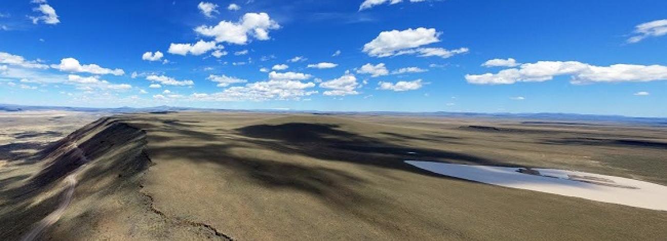
The Mahogany Ridge study area lies within the Trout Creek Mountain Range in southeastern Oregon. It is in the western edge of the mountains near the Nevada border. This part of the Trout Creek Mountains is characterized by a large, flat-topped plateau which gradually slopes to the north and west. The plateau is deeply gouged by three drainages which flow to the north and northwest. These three drainages and the large ridges which separate them are the major physical features of the Mahogany Ridge WSA.
The largest of the three drainages is Big Trout Creek Canyon. Flowing from south to north, Big Trout Creek runs the entire length of the study area, nearly dividing the WSA in half. The stream has cut a large canyon which reaches a depth of 1,600 feet near the center of the study area.
To the west of Big Trout Creek is Mahogany Ridge. This is one of the large, flat-topped ridgelines. The eastern side of the ridge is quite steep and contains a number of small spring-fed drainages which flow into Big Trout Creek. It is to the north and west of this ridgeline, along the northwestern boundary, that the study area reaches its lowest elevation of 4,640 feet. In the southern end of the study area, a ridge named “The V” lies on the east side of Big Trout Creek. Near the southern boundary, “The V” ridge reaches an elevation of 8,192 feet, the highest point in the study area.
East of “The V” is the East Fork of Trout Creek. This major drainage originates within the study area and flows over 5 miles before it joins Big Trout Creek near the center of the WSA. The East Fork also flows through a large canyon which reaches its maximum depth of almost 1,300 feet near the confluence with Big Trout Creek.
Paralleling the East Fork and the lower reaches of Big Trout Creek is the study area’s third major ridge, Center Ridge. This ridgeline primarily divides Big Trout Creek from Little Trout Creek, which drains the northeastern corner of the WSA. Like the East Fork, Little Trout Creek also originates within the study area. Little Trout Creek flows through the smallest canyon of the three drainages, which reaches a maximum depth of 740 feet.
There is a variety of vegetation within the Mahogany Ridge WSA. Although the dominant species in the study area is big sagebrush with a perennial grass understory, each of the three major drainages includes a variety of riparian species. Other prevalent species include aspen at the higher elevations, and mountain mahogany along the steeper slopes of the ridges.
The WSA was studied under Sections 603 and 202 of the Federal Land Policy and Management Act (FLPMA). Lands added after the wilderness inventory were studied under Section 202, also of FLPMA. These lands were included in the Final Oregon Wilderness Environmental Impact Statement (EIS) filed in February 1990.


