
Fortymile Wild and Scenic River
The Fortymile Wild and Scenic River is an extensive system of creeks and rivers in east-central Alaska near the Canadian Border. The river's numerous forks flow into the 'mainstem' Fortymile River, which joins the Yukon River in Canada. With 392 miles classified as wild, scenic, or recreational, the Fortymile River is the longest system within the National Wild and Scenic River network.
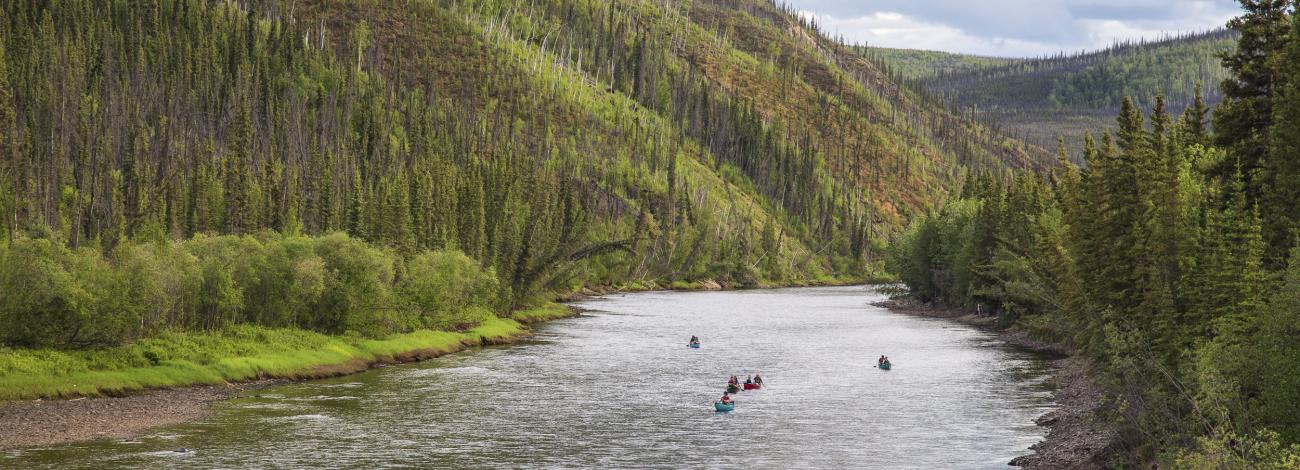
River float trips, camping, and sightseeing from the Taylor Highway are the primary attractions for visitors to the Fortymile Wild and Scenic River. For an Alaska river, the Fortymile has an unusual number of access points, making it possible to enjoy float trips that range from one day to several weeks in length. Boaters have many choices for recreational trips through deep, winding canyons lined by forests of birch, spruce and aspen. Gravel bars and river benches provide numerous primitive camping opportunities. Remnants of past mining operations dot the river banks as mementos of the area's rich mining history. The Fortymile is where gold was first discovered in Alaska. Gold mining continues to be a vibrant part of life in the region. Summer visitors will likely see signs of mining from yesterday and today.
Outstandingly Remarkable Values
- Natural Setting
Natural Setting
The landscape of the Fortymile Wild and Scenic River was formed over the past several million years as the river cut down through bedrock while the surrounding region underwent faulting and uplift. Signs of this downcutting can be seen numerous places on the sides of the valleys, where gravel river terraces are perched up to 800 feet above the current river level. In many places bluffs along the river expose folded metamorphic rocks. Most prominent of these are steeply tilted beds of white marble interspersed with gneiss and schist.
Alpine tundra, tussocks and boreal forest are among the many different types of plant communities found along the Fortymile River.
- Alpine tundra, found on ridges and mountain tops above the timberline, is characterized by dwarf shrubs, forbs, grasses, sedges and lichens. Near the timberline, there may be significant quantities of dwarfed white spruce.
- Tussock areas are flat to moderately sloping with poorly drained soils that support a cover of tussocks, clumps of sedges and grasses growing from small mounds, as well as scattered or stunted spruce.
- Boreal forest covers landscapes at lower elevations. Black spruce, sphagnum mosses, and scattered shrubs and willows are found in poorly drained areas where permanently frozen soil (permafrost) is near the surface. Better-drained hillsides and valley floors are home to white spruce, birch, willow and aspen. Blueberry and cranberry bushes provide vivid fall colors as well as tasty berries enjoyed by wildlife and people alike.
- Wildlife and Fish
Wildlife and Fish
The Fortymile Wild and Scenic River Corridor provides habitat for caribou, moose, Dall sheep, grizzly or black bear, furbearers, small game, raptors including the peregrine falcon, waterfowl, and numerous species of small mammals and birds.
The Fortymile caribou herd makes extensive use of the river corridor. Caribou are migratory animals, and the exact location of areas they use may change from year to year as herd size fluctuates and or migration routes change.
The Fortymile River is home to a number of fish species, including Arctic grayling, round whitefish, and burbot.
- History
History
The 1886 discovery of gold on Franklin's Bar on the Fortymile River touched off Interior Alaska's first gold rush. The mining boom ushered in a wave of settlement that forever changed the place, not only for its new residents but for the Athabascan Indians who occupied this region long before them. The miners who prospected nearly every creek in the region eventually extracted more than a half-million ounces of gold from the Fortymile, according to the Alaska Division of Geological and Geophysical Surveys.
Accompanying the miners, and profiting from them, were traders, merchants and freighters. Before the Taylor Highway was completed in 1953, there were no established roads into the Fortymile region. Miners and trappers wishing to replenish their supplies either had to haul everything themselves by boat, foot or horse, or they had to hire someone to do it for them. John Powers was one prominent freighter who used horses to transport miners' supplies to their claims.
During the heyday of Fortymile mining, the community of Steele Creek played an important role. Located on the main overland trail between the towns of Chicken and Eagle, Steele Creek served as a community center and transportation hub. At one time it included a trading post, post office and restaurant. Several cabins and a two-story roadhouse still stand on the site, now overgrown with tall grass and willows. This historic site is accessible via a hiking trail from mile 105 of the Taylor Highway, or by river access.
The military also figured prominently in the history of the Fortymile region. Reports of starvation and lawlessness among the miners resulted in the Army sending troops to the Eagle area to provide law enforcement in 1899. Soldiers soon began work on a trail from Valdez to Eagle. This trail, as well as construction of Fort Egbert in Eagle, did much to improve communication with the rest of the world.
In 1900 the military further improved communication through the construction of the Washington-Alaska Military Cable and Telegraph System (WAMCATS), which followed much of the Eagle-Valdez Trail. Messages that once took up to a year to reach Washington D.C. could now be sent in a matter of days. Remains of this system, eventually replaced by the wireless telegraph station in Eagle, may still be found throughout the Fortymile drainage.