Pacific Salmon Resiliency
Current projects improving resiliency of Pacific salmon
Total funding currently available for the restoration efforts in 2023: $2.75M
Stream Restoration
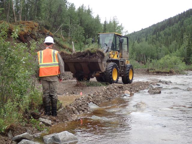
BLM-managed public lands in the upper Yukon River portion of Alaska have been the focus of applied research and the application of new techniques regarding stream reclamation since 2013. Many stream reclamation focused demonstration projects have been implemented over the last ten years and serve as outdoor classrooms for agency staff, industry stakeholders, and the public. In addition, the BLM has developed several resources to improve project success across the region including the publication of an interagency Stream Design Guide and Stream Reclamation Basics brochure. Despite these successes, significant restoration opportunities remain across the BLM Restoration Landscapes and throughout the surrounding Norton Sound-Yukon-Kuskokwim region.
Wade Creek Watershed
Wade Creek is part of the Fortymile Wild and Scenic River and has a rich history of placer mining dating back to the mid-1800s. Evidence of current and historic placer mining in the watershed remains today. Numerous sections of the creek are located on closed federal claims. Decades later and after mining has long ceased, these areas remain in a degraded state. BLM funded habitat enhancement projects have been largely successful at refining stream reconstruction techniques and improving stream function; however, one project failed during a high-water event three years after construction. Leveraging the knowledge learned from project’s success and failures is a basic tenet of adaptive management – what we can do better next time. We continue our work to stabilize the closed federal claims within the Wade Creek watershed. This not only benefits conditions within the wild and scenic river unit but also the local community and recreational users. The degraded conditions along Wade Creek contribute to repeated closures and routine maintenance to the Taylor Highway. Improving stream functions within the watershed would reduce impacts to existing highway infrastructure – which can be seen at Mile Post 86 on the highway. Additionally, the Taylor Highway area receives significant visitation by tourists during the summer, yet it provides little outreach or wayside exhibits explaining the region’s rich mining history and how science is being used to restore stream health.
Part of this project includes restoration efforts for Wade Creek. The work will restore thousands of feet of stream channel and associated fish habitat after historic placer gold mining disturbed the creek. In FY23, nearly 1,600 feet of stream was restored using a combination of proven techniques as well as some experimental methods. Work is anticipated to continue annually based on BIL and IRA funding. The project is funded by the Bipartisan Infrastructure Law.
Nome Creek Watershed
Like Wade Creek, Nome Creek has a rich history of placer mining. Located in the White Mountains National Recreation Area and in the headwaters of Beaver Creek National Wild and Scenic River, Nome Creek is the focus of several habitat improvement projects. Much of the past work is summarized in BLM Open File Report 113 (BLM 2007), which also includes recommendations for continued work to improve stream and floodplain functions. Much like Wade Creek, this project seeks to continue the stabilization of closed federal claims/abandoned mine lands in the watershed and address stream alignment issues which contribute to erosion of the Nome Creek Road and potential damage to the bridge. In July, over 1,000 feet of stream channel was restored to enhance habitats for Arctic grayling using a combination of proven techniques as well as some experimental methods like Wade Creek. The project also involved constructing new channel to improve alignment with a bridge span and reduce impacts to the road. Nome Creek is a popular grayling fishery in the area and a major tributary of Beaver Creek Wild and Scenic River. This area often sees high levels of visitation due to the nearby BLM designated campgrounds (Ophir Creek and Mt. Prindle).
Harrison Creek Watershed
The Harrison Creek project would continue restoration of approximately 10-miles of placer-mined stream channel on abandoned mine lands within the Harrison Creek watershed in the Steese National Conservation Area. Harrison Creek, a major tributary to Birch Creek National Wild and Scenic River, was extensively placer-mined for gold starting in the late 1890s. These mined areas were abandoned without adequate reclamation. In 2001, we initiated restoration efforts in the Harrison Creek watershed but were only able to complete restoration work on 1.5 miles of stream due to limited funding. The 2016 Steese Resource Management Plan specifically identified Harrison Creek as a High Priority Restoration Watershed--biological and physical processes and functions do not reflect natural conditions because of past and long-term human-caused land disturbances. This project would continue restoration efforts for closed federal claims in this high value watershed based on available funding.
Eastern Interior Invasive Species Management
Total funding currently available for invasive species management efforts in 2023: $300K
We'll be conducting comprehensive invasive species inventories in the Steese National Conservation Area, White Mountains National Recreation Area, Fortymile Wild and Scenic River Corridor, and adjacent BLM-managed public lands. The focus of the invasive species management will be on Beaver Creek, Birch Creek-Ikeenjik,* and Fortymile* wild and scenic rivers’ corridors (including upstream areas which may serve as sources of seeds and other plant propagating organisms), as well as roads, trail systems, and mined lands. We’ll prioritize necessary near-term treatment and control of discovered infestations. The discovered infestations inventory will serve as a basis to develop an invasive species management plan for each planning area (White Mountains NRA, Steese NCA, and Fortymile WSR), as recommended in the resource management documents for these areas. This project would be conducted through a multi-year cooperative agreement.
*Selected as official Inflation Reduction Act (IRA) Restoration Landscapes