
Revegetation and Wildlife Habitat Rehabilitation Criteria for Upland Mine Reclamation on BLM-Managed Lands in Alaska
United States Department of the Interior
BUREAU OF LAND MANAGEMENT
Alaska State Office
222 West Seventh Avenue, #13
Anchorage, Alaska 99513-7504
In Reply Refer To:
3809/3715 (AK930)
Instruction Memorandum No. AK-2017-
Expires: 9/30/2018
To: All District Managers, Field Managers, and Deputy State Directors
From: State Director
Subject: Revegetation and Wildlife Habitat Rehabilitation Criteria for Upland Mine Reclamation on BLM-Managed Lands in Alaska
Program Area: Mining Law Administration: Surface Management
Purpose: This policy will ensure that BLM-AK applies consistent and measurable parameters when evaluating revegetation of mining operations by providing BLM staff and miners with clear benchmarks for reclamation success. The criteria described in this IM apply to uplands and a delineated portion of the flood prone area disturbed by mining operations and complement Reclamation Effectiveness Monitoring (REM) criteria for placer-mined streams.
Policy: To meet the wildlife habitat rehabilitation objectives of 43 CFR 3809.420 (b)(3) for plans of operation and notices, the BLM-AK staff will use the revegetation and wildlife habitat criteria in this IM to: 1) assess reclamation completeness once a mine operator requests a final inspection for bond release, and 2) evaluate new or modified reclamation plans. Alternative criteria may apply to previously disturbed sites, extreme-environment sites that exhibit limited growing potential, or a delineated portion of the flood prone area disturbed by mining. These criteria do not apply to existing reclamation plans that contain explicit revegetative targets.
Vegetation and Wildlife Habitat Rehabilitation Criteria
Conventional BLM-AK field data indicate that naturally reclaimed sites attaining 70% plant cover generally exhibit levels of plant diversity, composition, and presence that are adequate for meeting vegetation and wildlife habitat reclamation goals in 43 CFR 3809.420[1]. When a miner requests final bond release, BLM-AK staff will use three criteria for evaluating upland mine site reclamation, unless a Site-Specific Assessment (SSA) applies. The reclaimed area:
- displays approximately 70% or more native plant foliar cover[2];
- demonstrates a minimum of two growing seasons; and
- exhibits the absence of non-native invasive species above baseline.
Staff will use the criteria in this IM to evaluate all completed reclamation work beginning in the 2017 field season. Additionally, staff may adjust the 70% cover criterion for disturbed baseline, extreme environment conditions, and sections of the flood prone area, as described under Baseline Conditions. If a miner plans to use commercial seed or plant products, staff should consult with the miner before seeding or planting to advise on an appropriate seed mix that will support the diversity goals for wildlife habitat rehabilitation.
The criteria will not apply to acreage for which a miner has requested a final reclamation inspection as of October 30, 2016, but which BLM has not yet approved. Rather, staff will approve final reclamation for this acreage when the site demonstrates a positive, self-sustaining revegetative trend for two growing seasons, based on recorded data. However, if unnecessary or undue degradation (UUD) is occurring or if a site has unresolved noncompliance issues, staff will require the operator to resolve the UUD or noncompliance issues and the revegetation and wildlife habitat rehabilitation criteria in this IM will apply to the affected acreage from that point forward.
New or Modified Reclamation Plans
New or modified reclamation plans will incorporate the three criteria described in this IM. The Administrative Officer (AO) may accept adjusted revegetation goals for all or part of the proposed disturbance area based on an SSA.
The BLM will use site baseline data to evaluate plans, as described in Attachment 1, Instructions to BLM Mining Compliance Specialists on Implementing Upland Area Revegetation Criteria. Staff should ensure there is documentation of baseline conditions before disturbance from any new mining activity, classifying site characteristics as Natural, Disturbed, Extreme environment, and/or delineated portion of a flood prone area. Notice-Level exploration projects with minimal surface disturbance may use site photos to establish baseline site conditions and to document reclamation completion, unless the miner requests an SSA or site conditions warrant the SSA.
Baseline Conditions
Natural sites have intact soil and species-rich plant communities with natural levels of vegetative cover and structural diversity. Disturbed sites have little to no soil, disturbed plant communities with limited species richness and/or extensive bare ground, and missing components of structural diversity. Extreme environment sites have naturally limited growth potential. Flood prone areas encompass the delineated section between the two- and three-times bankfull marks.
Site-Specific Assessment (SSA)
Site conditions may justify individual benchmarks. For this reason, the Authorized Officer (AO) may allow alternative criteria under an SSA. When a miner submits a written request for an SSA before mining or when the AO finds that the natural baseline revegetation and wildlife habitat rehabilitation criteria are difficult to achieve, the AO may ask a BLM-led Inter-Disciplinary (ID) team to recommend alternative foliar cover criteria. However, the AO will not allow an SSA for loss of topsoil due to poor practices or negligence.
If possible, the ID team will recommend alternative criteria before the start of mining operations. The team should consist of BLM or partner-agency staff with expertise in botany, wildlife, hydrology, soils, and mining compliance, as appropriate. The team will document site conditions and apply calculations using the BLM-AK SSA form. (See Attachment 2, Vegetation, Soil and Site Stability Assessments, Appendix 2 - Site Specific Assessment).
Under an SSA, staff may consider alternative wildlife habitat features as a substitute for surface cover. Achieving site stability, vegetation, and wildlife habitat may also require the creation or enhancement of soil. For existing reclamation plans, incorporation of alternative wildlife habitat features or soil amendments require a plan modification, which will be a minor modification.
The team may recommend that the AO adopt alternative foliar cover criteria less than 70%. However, the alternative criteria will need to ensure adequate cover for erosion control and adequate growth that promises suitable wildlife habitat. The minimum cover should not be below 35% for Interior Alaska and 15% for Arctic and western coastal areas.
Criteria Integration with Reclamation Effectiveness Monitoring (REM)
Within the flood prone area of a reclaimed or stabilized stream, the requirements outlined in AK IM 2017-011 always apply. Staff are to use two times the maximum depth at the bankfull stage to estimate the elevation and extent of the flood prone area (Rosgen 1996)[3]. This value is a function of the total width of the flood prone area available to the stream. Thus, staff should identify the boundary between riparian vegetation subject to REM and upland vegetation subject to this IM between two and three times maximum bankfull.
Fisheries and hydrology staff are essential to delineating the flood prone area. Staff are also to coordinate with the miner on the boundary between the two zones when developing reclamation plans and evaluating reclamation.
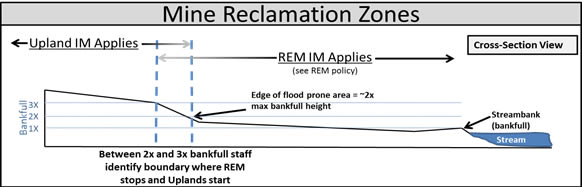
Figure 1– Cross Section Illustrating Upland IM and REM IM Boundaries
Non-Native Invasive Species or Weeds
If non-native invasive species occur at a reclaimed site, staff will work with miners to incorporate adaptive management practices for the inventory, monitoring, control, and potential removal of the infestations.
Preliminary Approval (PA) for Placer Mine Reclamation
The AO may allow the use of PAs (IM-2017-002) outside withdrawn areas. If the AO determines that circumstances warrant, the criteria in this IM will apply to those areas under PA status.
Timeframe: Effective immediately.
Budget Impact: Significant budget impact is likely. Interdisciplinary Teams may need to travel to mine sites that are remote, air-accessible, and require several days’ time. Outreach and coordination with stakeholders may require additional time and financial resources. Field data collection and office processing may incur further costs. Technical assistance, education, and publication of technical and educational material may affect planned spending. However, clear reclamation criteria established before mining begins may reduce costs of repeated site visits to discuss or evaluate reclamation progress. Additionally, BLM staff may achieve cost reductions through baseline data gathering during site visits that are years in advance of mining, thus reducing the need for a site visit before each new mine startup.
Directives Affected: None.
Coordination: BLM Alaska State Office and BLM Alaska Field Offices.
Contact: Joseph Galluzzi, 907-271-3236, [email protected], or Casey Burns, 907-271-3128, [email protected].
Signed by: Bud C. Cribley, Alaska State Director
Authenticated by: Joseph Lotz, Records Manager
Attachments:
- Instructions to BLM Mining Compliance Staff on Implementing Upland Revegetation Criteria (10 pp)
- Vegetation, Soil, and Site Assessments (15 pp)
- Revegetation and Reclamation Sample Photos (14 pp)
[1] The BLM measured revegetation success at various placer mines throughout the state during the 2016 mining season. Results from these measurements indicate that many placer mine sites can reasonably achieve 70% vegetative cover in two to five years with four years being the most common success. Desktop studies comparing reclamation photos to pre-mined photos indicate that using the suggested BMPs can result in accelerated revegetation. Additionally, 70% cover is a common industry standard, and is a number supported by a wide range of stakeholders in Alaska. (See Attachment 3, Examples of Revegetation Percent Cover)
[2] Staff may count moss (two inches or greater in thickness) and non-crustose lichen as foliar cover.
[3] Rosgen, D.L. and H.L. Silvey. 1996. Applied River Morphology. Wildland Hydrology Books, Fort Collins, CO.