
Dominguez-Escalante National Conservation Area
Dominguez-Escalante National Conservation Area comprises 210,172 acres of protected public lands and includes the 66,280-acre Dominguez Canyon Wilderness. The NCA was created by the 2009 Omnibus Public Lands Management Act and is managed as part of the Bureau of Land Management’s National Conservation Lands.
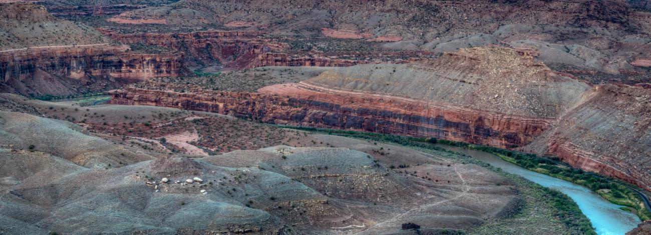
Known for its breathtaking scenery, Dominguez-Escalante NCA is a fine example of the spectacular canyon country of the Uncompahgre Plateau. Red-rock canyons and sandstone bluffs hold geological and paleontological resources spanning 600 million years, as well as many cultural and historic sites. The Ute Tribes today consider these piñon-juniper–covered lands an important connection to their ancestral past.
The Escalante, Cottonwood, Little Dominguez and Big Dominguez Creeks cascade through sandstone canyon walls that drain the eastern Uncompahgre Plateau. Unaweep Canyon on the northern boundary of the NCA contains globally significant geological resources. Elevations in the NCA are approximately 4,800 to 8,200 feet.
Nearly 30 miles of the Gunnison River flow through Dominguez-Escalante NCA, supporting fish, wildlife and recreational resources. The Old Spanish National Historic Trail, a 19th Century land trade route, also passes through it. A variety of wildlife call the area home, including desert bighorn sheep, mule deer, golden eagles, turkeys, elk, mountain lions, black bears, and collared lizards. There are 115 miles of streams and rivers in the NCA, and there is habitat suitable for 52 protected species of animals and plants.
- Recreation Areas
Cactus Park: This area provides rich opportunities to motorized vehicle enthusiasts to experience the back country. Miles of trails wind within the NCA provide access to the Uncompahgre National Forest, which manages a successful multi-recreational trail system. Opportunity exists for BLM to link into this system. The 142-mile Tabeguache Mountain Bike Trail, which connects Grand Junction to Montrose, goes from Cactus Park on its ascent from Grand Junction to the top of the Uncompahgre Plateau. Visitors interested in the geology of the area can stop at the Gunnison Gravels Area of Critical Environmental Concern, which contains geologic evidence of the ancestral route of the Gunnison River through Unaweep Canyon.
Gunnison River: The relatively flat stretch of river between Escalante Canyon and the mouth of the Dominguez Canyon attracts commercial and private boaters, with its unprecedented views of stunning red-rock canyons and wildlife viewing opportunities. Nearly 30 miles of the river flow through the NCA. Campsites are marked and available along the river. Read more about floating the Gunnison River.
Escalante Canyon: Escalante Canyon includes the Potholes Recreation Area, popular with extreme kayakers in the spring and picnickers in the summer. Restrooms and picnic tables are available for day-use recreation as well. The Escalante Canyon Area of Critical Environmental Concern contains sensitive plant species, natural seeps, and several globally-unique plant associations including beautiful hanging gardens of small-flowered columbine and Eastwood’s monkeyflower. A 15-mile county road offers visitors a trip back to pioneer days through Escalante Canyon’s “Red Hole in Time” (popularized by local author Muriel Marshall). The road provides easy vehicle and viewing access to historic cabins and trails, rock walls with early settler and Native American inscriptions, and spectacular geologic formations.
Escalante Potholes Recreation Area underwater currents pose danger: Hidden currents found in the potholes formations can catch and keep you underwater, regardless of river flows or your swimming skills. Jumping and diving in the potholes is prohibited. Kiosks and signage at the 3-acre site warn visitors of the dangerous conditions. The BLM and Delta County Sheriff's Office attempt to coordinate patrols to increase public safety. Personal responsibility is especially critical given that radio and cell phone reception in the canyon is often poor to non-existent.
Sawmill Mesa: Immediately adjacent to the town of Delta, this area provides critical motorized links to the Uncompahgre National Forest. The Delta-Nucla/25-Mesa Road borders the NCA on the southeast and connects Delta to Nucla and the Divide Road, which follows the spine of the Uncompahgre Plateau. Sawmill Mesa Road and Dry Mesa Road provide U.S. Forest Service access to hunting in the fall and 4-wheel drive, ATV, and mountain bike access spring, summer, and fall. This area is rich in history, providing the only access route for settlers in Escalante Creek to Delta in the 1800s and early 1900s.
Hunting Grounds: West of Hwy 50 and east of the Gunnison River this area is rich in cultural heritage resources and a popular location for dispersed recreation. The area was the traditional hunting area for Ute and Fremont Indians that migrated and hunted through the area. The area provides valuable opportunities for many different forms of recreation, particularly OHV and horseback riding.
Ninemile Hill: As a result of its close proximity to the Grand Valley, this area is valued for its easily available recreation opportunities for nonmotorized recreation. This is a popular area for relatively unimproved exploration via hiking and horseback riding. The Tabeguache Trail, a long-distance mixed-use trail popular with mountain bikers, motorcycle riders and jeep enthusiasts, also runs through the Ninemile Hill area. Ninemile Hill is easily identifiable by its communication towers along the crest.
East Creek: Unaweep Canyon is on the northern boundary of the NCA. The canyon is unique because it has drainages running east and west out of the canyon. East Creek is the eastern drainage that runs along Hwy141 which is designated by the state of Colorado as the Unaweep-Tabeguache Scenic Byway. Scenic auto touring, bouldering and multi pitch climbing occur along East Creek.
- Dominguez-Canyon Wilderness
The Dominguez-Canyon Wilderness displays an array of ecosystems, ranging from upper Sonoran piñon-juniper desert along the Gunnison River, to Douglas-fir and ponderosa pine to aspen at higher elevations. Dominguez Canyon Wilderness consists of two major canyon systems, Big Dominguez and Little Dominguez. The canyons drain the northeastern corner of the Uncompahgre Plateau. Little Dominguez is the longer of the two at approximately 12 miles in length. It joins the larger Big Dominguez Canyon a little over a mile before their confluence with the Gunnison River.
The area possesses outstanding geological features, spectacular scenery, ecological diversity, two cascading mountain streams and opportunities for solitude and primitive unconfined recreation. The terrain is characterized by large mesas dissected by deep red slick-rock canyons and arroyos. The area provides valuable wildlife habitat for desert bighorn sheep, deer, elk, mountain lion, black bear, wild turkey and chukar.
Fishing is year-round in Big Dominguez Creek. Plenty of other recreational opportunities are available for your enjoyment such as, camping, hiking, horseback riding and don't forget your camera. More information about recreating in Dominguez Canyon Wilderness is available online.
Cultural resources such as petroglyphs and wickiups attest to the thousands of years that Native Americans used the area for hunting, shelter and as a travel corridor from the Gunnison River Valley to the Uncompahgre Plateau. Traces of the early miners and settlers who lived and worked there are also evident.
- Old Spanish National Historic Trail
The Old Spanish National Historic Trail recognizes the land route traveled by traders from 19th-century Mexico - today's New Mexico - and California. From 1829 to 1848, this trail was the shortest-known route from Santa Fe to Los Angeles, through red-rock mesas, below snow-capped peaks, and fording untamed rivers, following a loose network of Native American footpaths across the Colorado Plateau and Mojave Desert.
The Old Spanish National Historic Trail is composed of three main routes: the Main Route, the Armijo Route, and the North Branch. Use would depend on peril, weather, or simple opportunistic stops.
Mules were the highest-valued pack animals, as they had incredible strength and endurance, fared better than horses where water was scarce and forage poor, and recovered more rapidly after periods of hardship.
- Know Before You Go
Dominguez-Escalante National Conservation Area was designated with broad local, regional and national support by Congress in 2009. Traditional uses such as livestock grazing, hunting and fishing are important uses in the NCA and are specifically protected by the designating legislation and resource management plan.
You may encounter livestock when visiting the NCA. Please close gates behind you, beware of sheep dogs and avoid interfering with livestock operations.
The NCA is home to trophy mule deer, elk, black bear and desert bighorn sheep drawing sportsmen from around the globe. Big game, upland bird and migratory waterfowl hunting contributes millions to the regional economy and is a valued activity in the NCA.
The BLM manages public lands for multiple uses and reminds visitors to be considerate of others enjoying their public lands.
The NCA's terrain ranges from dry, high plains desert, mountain timber to deep canyons along the Gunnison River. The BLM recommends you let someone know your plans before visiting and to bring along plenty of water due to limited water availability. You will encounter picturesque views, fascinating historical artifacts, as well as unique plants and geologic features. Leave artifacts as you find them. Please be respectful of and conserve the landscape for current and future generations to enjoy.
- Map Links