
A petroglyph site in New Mexico combines raw natural beauty and human expression
At the Bureau of Land Management’s Three Rivers Petroglyph Site, early spring exposes the raw beauty of carvings etched into stone by ancient Jornada Mogollon people, who lived in a nearby village site more than 1,500 years ago. Set into public land, the site connects nature to history.
“Few sites have petroglyphs with the village site right there,” said BLM Las Cruces District Office archaeologist Trinity Miller. “We know that the petroglyphs are from the same people because it is the same iconography found on artifacts from the village. They are dated to the same time period, that of the Jornada Mogollon. That’s the link.”
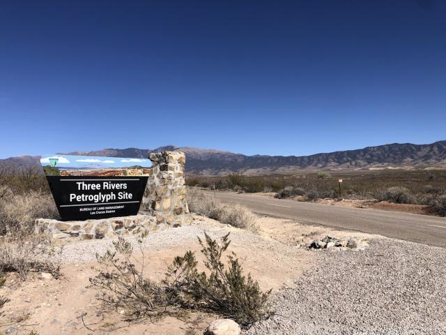
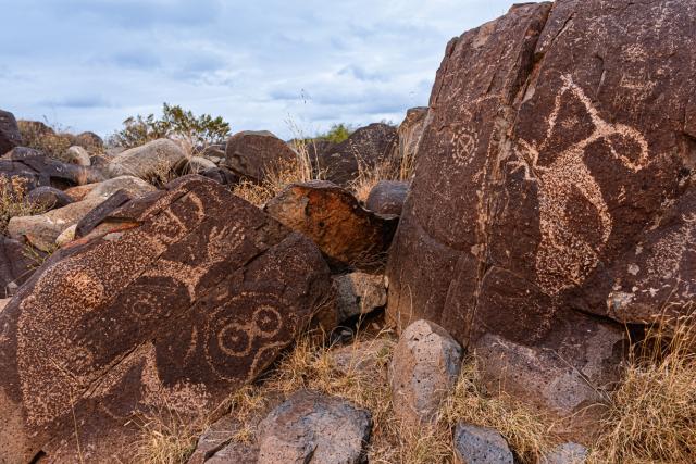
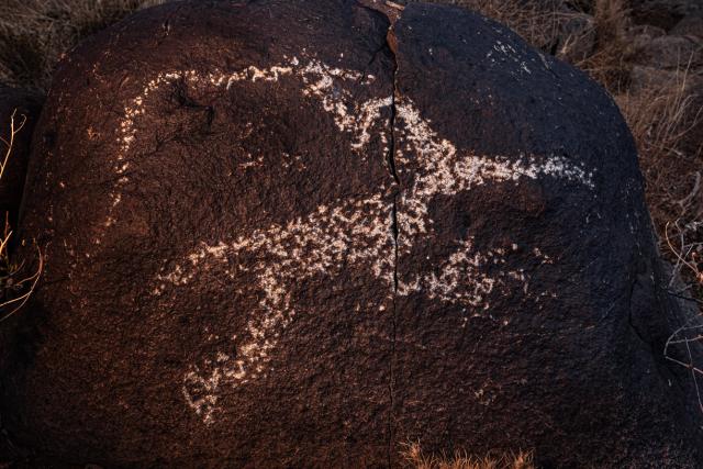
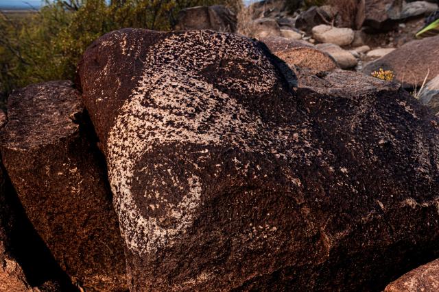
Managed by the BLM’s Las Cruces District Office, the site lies between Tularosa and Carrizozo in Otero County, southern New Mexico. The agency maintains trails, interpretive signage, and visitor facilities to ensure public access while preserving the integrity of this archaeological treasure. Masks, sunbursts, wildlife, handprints, and geometric designs adorn the basaltic ridge.
Two short trails—the Petroglyph Trail and Village Trail—guide visitors through thousands of carvings and a partially excavated Jornada Mogollon settlement in the Chihuahuan Desert.
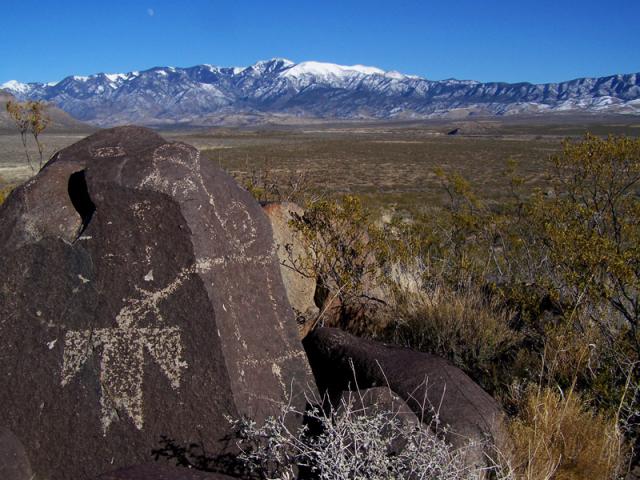
The site features more than 21,000 petroglyphs, mostly created by the Jornada Mogollon who lived in the Tularosa Basin between 500 AD and 1450 AD. Water, then more plentiful, was redirected to cultivate corn, beans, and squash in addition to wild foods growing in what used to be vast grasslands. Three streams, then regularly fed from the east by the Sacramento Mountains, would have converged nearby: Indian Creek, Golondrina “Swallow” Creek, and Three Rivers. Birds and wildlife, another food source, would have used the area for habitat and migration.
Few sites have petroglyphs with the village site right there.
Gypsum from the nearby White Sands was used to line floors in the village, supporting evidence of continual settlement. Ceramics and other trade wares found at Three Rivers indicate regional trade among Jornada Mogollon villages and with other Mogollon groups, such as the Mimbres Mogollon. Three Rivers’ trade networks extended to hundreds of miles away, including with the Casas Grandes people in what is now northern Mexico.
“The geography and resources made this an important area,” Miller said, noting that various Jornada Mogollon groups would have occupied Three Rivers on a seasonal basis to take advantage of those natural resources.
Inhabitants would have been treated to attractive scenery.
“There are so many geologic landforms visible from there," Miller said. "Standing on the ridge, you're looking east toward Sierra Blanca Peak, or the White Sands glittering to the west along the base of the San Andres Mountains, or black lava flows at Valley of Fires to the north.”
By the time Spanish explorers arrived in the 1540s, the Jornada Mogollon civilization was gone, with no record of where they went. The reason for their departure is a topic of ongoing study. Some point to environmental changes. Others point to overpopulation, to war, or to the abandonment of agriculture, or all the above.
Today, Apache and Puebloan people maintain strong cultural ties to Three Rivers.
The BLM manages Three Rivers as a recreational site for day and overnight use. Amenities include the visitor center, restroom facilities, the Petroglyph and Village trails, camp and picnic sites, RV hookups, and site hosts.
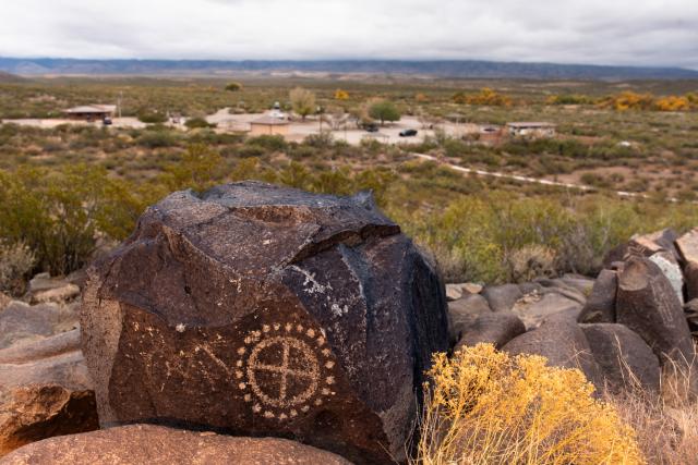
In recent years, the agency improved the accessibility of Three Rivers by making portions of the Petroglyph trail ADA-accessible. A cement portion of the trail leads to some petroglyphs, and two binocular viewfinders give people a chance to see more petroglyphs on the ridge. Along the Village Trail to the ancient settlement, the agency has stabilized the walkway against erosion. At the visitor center, the Public Lands Interpretive Association operates a bookshop.
The site is open year-round, but the springtime offers a chance to experience the petroglyphs in a multi-sensory setting.
The sun, returning from its winter position, floods the images with low-angle light. High-desert winds susurrate against the foliage, producing a soft rustle among plants and grasses. Creosote leaves emit a fragrance of petrichor, which is the smell of rain falling on dry soil. To the east, heat waves distort the foothills of the nearly 12,000-foot Sierra Blanca Peak, an ancient volcano revered by the Mescalero Apache.
On the mile-long Petroglyph Trail, visitors can spot the portrait of a bighorn sheep, or a horned deer-like figure poised in mid-motion. Numerous abstract patterns, etched with care and smoothed by time, reflect both symbolic meaning and artistic expression. The carvings seem to never end, suggesting a long tradition of storytelling and expression—a plein air chat room crafted by the tapping of hand tools.
What do the petroglyphs mean? That’s unsolved. But one acclaimed Native American writer offers this perspective: In ancient times, abstract symbols expressing key elements helped people unlock and structure a deep connection to the sky and earth around them.
“Pictographs and petroglyphs of constellations or elk or antelope draw their magic in part from the process wherein the focus of all prayer and concentration is upon the thing itself,” writes Leslie Marmon Silko in her 1996 essay Interior and Exterior Landscapes: The Pueblo Migration Stories, a key text in understanding the cultural geography of the Southwest. “Connection with the spirit dimensions requires a figure or form that is all-inclusive. A ‘lifelike’ rendering of an elk is too restrictive.”
People made the petroglyphs, but you can also see nature’s accents—dark hornblende crystals indicate where time has cleaved away chunks of stone. The crystals measure up to two inches across, adding texture and depth to the ancient canvas. The ridge itself is mostly volcanic rock more than 36 million years old. Nearby geologic formations record the rise and fall of ancient seas, including the Western Interior Seaway that bisected North America 100 million years ago. During the last ice age, people before the Jornada Mogollon lived in the region between 20,000 and 23,000 years ago, according to numerous footprints found in White Sands National Park to the southeast.
“The Tularosa Basin has been significant to people for thousands and thousands of years,” said Miller. “Many cultures that came before are acknowledged in tribal oral histories.”
Three Rivers has also seen more recent history: Billy the Kid roamed the area during the Lincoln County Wars in the late 1800s; the first atomic bomb was tested about an hour west in 1945; and Smokey Bear was rescued from a forest fire in 1950 in the Capitan Mountains to the northeast.
Each year, approximately 48,000 people visit the Three Rivers site, which is part of a larger 960-acre section of public land. As part of BLM’s commitment to Leave No Trace principles, the agency encourages visitors to stay on trails and avoid altering petroglyphs. Removing artifacts is prohibited.
It’s easy to lose track of time here, knowing that 1,500 years ago, people used hand tools to form any one of these designs. Here stood the last Jornada Mogollon artist, brushing and blowing aside chipped debris, preparing to leave the site to evolve on its own. When the people departed, the light we see today from the Orion Nebula—just below Orion’s belt—had just begun speeding toward Earth.
At present, the carvings at Three Rivers are getting their spring touch-ups from crevice winds, precious moisture, and sunlight. Looking beyond the weathered imagery, one sees the same elements shaping the open country of the Tularosa Basin. In that moment, the petroglyphs and the landscape are so like each other that it’s impossible to say which is which.
Related Stories
- BLM, Partners Enhance Public Access at Popular Recreation Area
- Birding Aravaipa Canyon: A morning of songs, color, and creekside adventure
- Framed for Freedom: Bureau of Land Management Eastern States and the Legacy of National Historic Trails
- BLM Celebrates America’s 250th Anniversary in Oregon
- Volunteers and Partners Retrace 250 Years of History on the Anza Trail