
San Pedro Riparian National Conservation Area Map
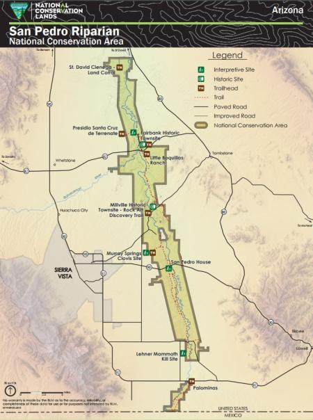
This free, downloadable PDF map shows the San Pedro Riparian National Conservation Area (NCA) in Cochise County, southeastern Arizona, managed by the Bureau of Land Management (BLM) Tucson Field Office. This map can be printed or viewed on any computer, tablet, or phone. It is not a georeferenced map and does not display GPS location on a mobile device.
The NCA protects one of the last free-flowing rivers in the American Southwest and one of the most important riparian corridors in North America. The NCA follows the San Pedro River from the United States-Mexico border northward through Cochise County. The NCA boundary is shown on the map.
Interpretive sites, historic sites, and trailheads are shown on the map with distinct symbols. Trails are shown as dashed red lines. Named sites shown on the map include:
- Fairbank Historic Townsite
- Lehner Mammoth Kill Site
- Little Boquillas Ranch
- Millville Historic Townsite – Rock Art Discovery Trail
- Murray Springs Clovis Site
- Palominas
- Presidio Santa Cruz de Terrenate
- San Pedro House
- St. David Cienega – Land Corral
Paved roads are shown as solid dark lines and improved roads are shown as solid gray lines. State highways shown include State Route 80, State Route 82, State Route 90, and State Route 92. Reference directions to Benson, McNeal, Sonoita, and St. David are shown for geographic orientation. Named communities shown on the map include Bisbee, Huachuca City, Lowell, Palominas, Sierra Vista, Tombstone, and Whetstone.
The San Pedro River runs the length of the NCA from south to north and is shown in blue. The Babocomari River is shown joining the San Pedro River from the west in the central portion of the map.
This map was produced in 2015. The map number is M14-09-01.
For questions, contact the Tucson Field Office.
No warranty is made by the BLM as to the accuracy, reliability, or completeness of these data for use or for purposes not intended by the BLM.