
BLM Arizona Wilderness and Wilderness Study Areas Map
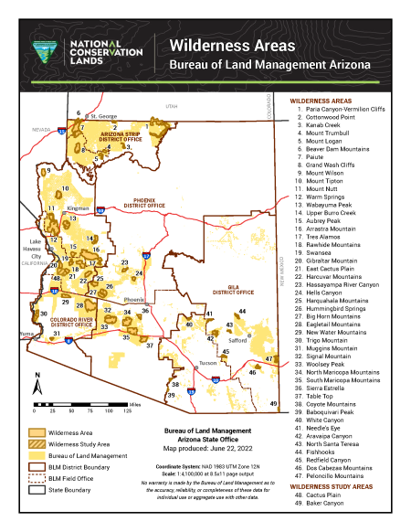
This free, downloadable PDF map shows all Bureau of Land Management (BLM) wilderness areas and wilderness study areas in Arizona. Wilderness areas are lands designated by Congress, and wilderness study areas are lands with wilderness characteristics that are being evaluated for potential wilderness designation by Congress.
Each area is numbered on the map and listed in a directory on the right side of the map for easy reference.
Wilderness Areas are shown in dark gold. There are 47 designated BLM wilderness areas in Arizona:
- Paria Canyon-Vermilion Cliffs
- Cottonwood Point
- Kanab Creek
- Mount Trumbull
- Mount Logan
- Beaver Dam Mountains
- Paiute
- Grand Wash Cliffs
- Mount Wilson
- Mount Tipton
- Mount Nutt
- Warm Springs
- Wabayuma Peak
- Upper Burro Creek
- Aubrey Peak
- Arrastra Mountain
- Tres Alamos
- Rawhide Mountains
- Swansea
- Gibraltar Mountain
- East Cactus Plain
- Harcuvar Mountains
- Hassayampa River Canyon
- Hells Canyon
- Harquahala Mountains
- Hummingbird Springs
- Big Horn Mountains
- Eagletail Mountains
- New Water Mountains
- Trigo Mountain
- Muggins Mountain
- Signal Mountain
- Woolsey Peak
- North Maricopa Mountains
- South Maricopa Mountains
- Sierra Estrella
- Table Top
- Coyote Mountains
- Baboquivari Peak
- White Canyon
- Needle's Eye
- Aravaipa Canyon
- North Santa Teresa
- Fishhooks
- Redfield Canyon
- Dos Cabezas Mountains
- Peloncillo Mountains
Wilderness study areas are shown in a gold crosshatch pattern. There are two BLM wilderness study areas in Arizona:
The map was produced by the BLM Arizona State Office on June 22, 2022, using the NAD 1983 UTM Zone 12N coordinate system at a scale of 1:4,100,000 for standard 8.5×11-inch page output. Arizona's borders with Utah, Colorado, New Mexico, Nevada, and California are included for geographic reference.
For questions, contact the BLM Arizona State Office by phone at 602-417-9200 or by email at [email protected]. You can also contact the BLM office that manages the area you plan to visit.
No warranty is made by the Bureau of Land Management as to the accuracy, reliability, or completeness of these data for individual use or aggregate use with other data.