
BLM Arizona National Conservation Lands Map
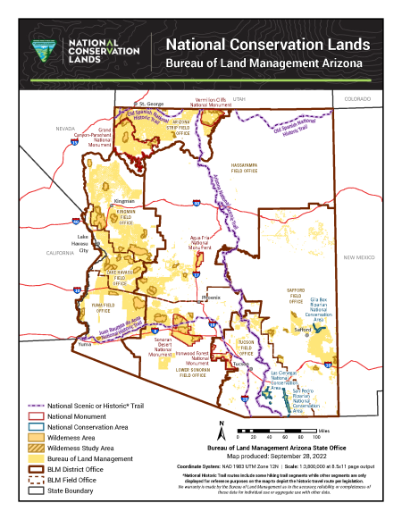
This free, downloadable PDF map shows all Bureau of Land Management (BLM) National Conservation Lands in Arizona, including national monuments, national conservation areas, wilderness areas, wilderness study areas, and national scenic and historic trails. These are some of Arizona's most protected and scenic public lands, managed by the BLM to conserve their outstanding natural, cultural, and recreational values.
- National scenic or historic trails are shown as a dashed purple line. Note: National historic trail routes include some hiking trail segments. Other segments are displayed for reference purposes only to depict the historic travel route per legislation.
- Three of these trails cross BLM-managed lands in Arizona:
- The Arizona National Scenic Trail runs north to south through central Arizona.
- The Old Spanish National Historic Trail crosses northern Arizona.
- The Juan Bautista de Anza National Historic Trail runs through southern Arizona.
- Three of these trails cross BLM-managed lands in Arizona:
- National monuments are shown with a red boundary.
- This map includes five BLM-managed national monuments in Arizona: Grand Canyon-Parashant, Vermilion Cliffs, Agua Fria, Sonoran Desert, and Ironwood Forest national monuments. Because this map was created in 2022, it does not include the Baaj Nwaavjo I'tah Kukveni – Ancestral Footprints of the Grand Canyon National Monument, which was established in August 2023.
- National conservation areas are shown with a teal boundary.
- Three national conservation areas are administered by the BLM in Arizona: San Pedro Riparian, Las Cienegas, and Gila Box Riparian national conservation areas.
- Wilderness areas are shown in dark yellow with a bold boundary line. Dark yellow represents lands designated by Congress as wilderness.
- Wilderness study areas are shown in a gold crosshatch pattern, representing lands with wilderness characteristics that are being evaluated for potential wilderness designation.
- Bureau of Land Management lands are shown in light yellow and represent all public lands in Arizona managed by the BLM.
- BLM district offices are shown with a solid dark brown boundary. Four district offices oversee BLM operations across Arizona: the Arizona Strip, Colorado River, Phoenix, and Gila district offices.
- BLM field offices are shown with a dashed dark brown boundary. Seven field offices manage day-to-day operations within their districts: the Arizona Strip, Kingman, Lake Havasu, Hassayampa, Lower Sonoran, Yuma, Safford, and Tucson field offices.
The map was produced by the BLM Arizona State Office on Sept. 28, 2022, using the NAD 1983 UTM Zone 12N coordinate system at a scale of 1:3,800,000 for standard 8.5×11-inch page output. Arizona's borders with Utah, Colorado, New Mexico, Nevada, and California are included for geographic reference.
For questions, contact the BLM Arizona State Office by phone at 602-417-9200 or by email at [email protected]. You can also contact the BLM office that manages the area you plan to visit.
No warranty is made by the Bureau of Land Management as to the accuracy, reliability, or completeness of these data for individual use or aggregate use with other data.