
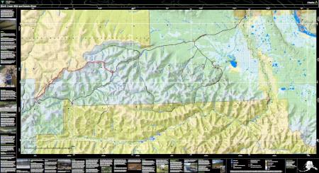
Birch Creek Wild and Scenic River Georeferenced PDF Map
Click the filename at the bottom of the page to open the map.
This PDF map is designed for use on your GPS-enabled mobile device and can be displayed on any PDF reader. When viewed in an installed mobile map application, this map is designed so that your location can be displayed on screen in real time.
Georeferenced map applications allow you to navigate using your mobile device’s GPS even without cellular reception. There are a variety of georeferenced PDF apps available for Apple and Android devices.
This map is not intended to be used to identify lands open to federal subsistence hunting.
Find more BLM Georeferenced maps at www.blm.gov/maps
Monitoring River Levels
Birch Creek above Twelvemile Creek - BCTA2 - The stream gauge near the put-in at the Upper Birch Creek Wayside at Milepost 94 Steese Highway reports water stage, water temperature, air temperature, cumulative precipitation and water turbidity at 15-minute intervals. Current observations are available on the National Weather Service's Hydrometeorological Automated Data System (HADS) website (https://hads.ncep.noaa.gov/charts/AK.shtml).
- Stage of less than 1.0 feet is very low flow, meaning difficult floating, especially for rafts.
- Stage of 2 feet is moderate flow --good float conditions.
- Stage of 3 to 3.5 feet or above is considered high water; be prepared for fast current, floating logs, flooded campsites, and potentially dangerous conditions.