
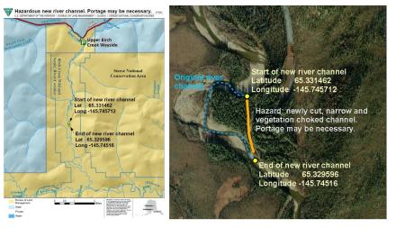
Upper Birch Creek Wild and Scenic River hazardous new channel
Click the filename below to download the map and the satellite image of upper Birch Creek Wild and Scenic River with the location of the new, hazardous river channel.
- Start of the new river channel: Lat 65.331462; Long -145.745712
- End of new river channel: Lat 65.32959; Long -145.74516
In late July 2023, this hazardous new river channel was discovered a few miles downriver from the Upper Birch Creek Wayside. At the time of discovery, during the low flow stages of late July, the entire river flowed into a log-jam and debris-choked channel, requiring a ¼ mile portage through the original, dry river channel.
At higher river stage levels, we don't know what this hazard means for boaters. Boaters should plan to scout the hazard and be prepared to portage gear around the hazard.
New river channels can take years to clear debris and become safe for boating. Use caution.