
Bizz Johnson National Recreation Trail |
Overview
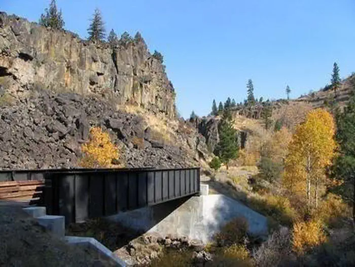
The Bizz Johnson National Recreation Non-Motorized Trail follows the old Fernley and Lassen Branch Line of the Southern Pacific railroad, the trail winds 25.4 miles from Susanville, California to Mason Station. For the first 16 miles, the trail follows the Susan River. As it winds through the rugged Susan River Canyon, the trail crosses the river 12 times on bridges and trestles and passes through two tunnels.
The landscape is a combination of semi-arid canyon and upland forests of pine and fir. Most of the trail traverses the Susan River Canyon with beautiful views of the surrounding mountains and reminders of the railroad and logging days of the past. The remarkable autumn colors and scenery along the Bizz Johnson Trail earned it one of eight feature spots on the Rails-To-Trails Conservancy's 1997 "Fall Foliage on the Web" rail-trails guide.
Download a brochure and map of the Bizz Johnson National Recreation Trail
See more photos of the Bizz Johnson National Recreation Trail
Rails to Trails Festival
The annual Rails to Trails Festival is held yearly in October at 601 Richmond Road in Susanville, Ca. The Festival is held by the Lassen Lands and Trails Trust yearly at the Historic Railroad Depot across from the Bizz Johnson Susanville Trailhead. For more information contact the BLM Eagle Lake Field Office at 530-257-0456 or visit the Lassen Lands and Trails Trust (LLTT) website.
Click here for more information about the Rails To Trails Festival
Trail Information
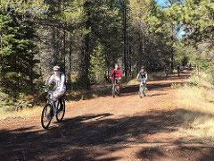
There are no fees required. Please pack out what you pack in along the trail. Recreation opportunities include: Hiking, Mountain biking, Horseback riding (for those who own or bring their own), Fishing, Swimming, Cross-country skiing, Snowmobile riding (west of Devils Corral only), Wildflower viewing, Wildlife viewing, Bird watching and Dog walking
To protect natural resources and provide a safe recreation experience for all, certain regulations are in effect along the trail. Please obey posted signs and share the trails
Help prevent trail damage during wet or muddy conditions. Please stay off the trail when it is wet or muddy to avoid leaving deep bike ruts, deep footprints, and deep holes from horse hooves.
Bizz Johnson Trailheads
Photos
SHUTTLES FOR BIKERS AND HIKERS
Monday through Saturday
A bus that can carry 8 bikes runs between Susanville and Westwood. For current schedule and bus stops, call Lassen Rural Bus at (530) 252-7433 or check www.lassentransportation.com and look for West County bus route and schedule.
Sundays and times not served by the bus
Arrange for a shuttle through, Susanville Taxi, (530) 257-5277 located at 620 Richmond Road, about 1/4 block directly south of the Bizz Johnson Trail’s Susanville Trailhead (Susanville Depot and caboose).
GROUP SHUTTLES
For information on scheduling a shuttle for groups of more than 6 people and for reserving your space on the popular Fall Color Ride bus shuttle in late October call BLM at (530) 257-0456.
TRAIL COURTESY
Walkers and bicyclists yield to horseback riders. When overtaking another trail user, let them know you are approaching so you do not startle them or their horses.
CAMPING AND LODGING FACILITIES
Primitive camping is permitted along the trail on BLM and U.S. Forest Service lands.
Lodging is available in Susanville, Westwood and the surrounding area. For a list of area lodging, call the Lassen County Chamber of Commerce at (530) 257-4323.
BICYCLING
Bicycling on the Bizz Johnson Trail is best enjoyed on wide-tire bicycles. Multi-geared mountain bicycles are excellent for trail use, but single-speed wide-tire bicycles are also suitable. The trail surface consists of a relatively level railroad grade (3 percent maximum) composed of aggregate material.
The trail gradually climbs 500 feet in the first 12 miles from Westwood to Westwood Junction, then drops 1,300 feet in the 18 miles between Westwood Junction and Susanville. Wide-tire bicycles can easily travel the entire trail. Exercise caution when crossing planking on decked bridges and when traveling through unlighted tunnels.
HIKING
If you plan to hike the trail, you will find the 18-mile segment along the Susan River from Westwood Junction to Susanville most scenic because of the variety afforded by the adjacent river and canyon and views of the surrounding mountains. It is an easy hike with maximum
3 percent grade.
A variety of day hikes are possible from the many trailheads. By arranging your own shuttle between trailheads, hikers can enjoy more of the trail without backtracking. Backpacking can also be enjoyed along the trail.
EQUESTRIAN
Eleven bridges are passable on horseback, as are two tunnels, one 800 feet long, the other 450 feet. If you wish to avoid the tunnels, riverside trails provide alternate routes.
FISHING
Fishing in the Susan River is best in spring to early summer. The river provides habitat for rainbow and brown trout, speckled dace, lahontan residue, and Tahoe sucker. Twice monthly in May, June, and July, the California Department of Fish and Game plants rainbow trout in the lower Susan River between Susanville and Devils Corral. Stocking of fish generally ends in July when river temperature peaks reach 70-75 degrees Fahrenheit.
CROSS-COUNTRY SKIING
The best areas for cross-country skiing are on the trail's upper 18.5-mile segment, west of Highway 36 and the Devils Corral area. Elevations from 4,760 feet to 5,500 feet, northern exposures and shading combine to provide the most reliable snow conditions.
A recommended trail segment for cross-country combines snowed-in road skiing from Highway 44 to Goumaz (three miles) with trail skiing from Goumaz to Highway 36. This nine-mile segment affords a gentle downhill slope with good views of the Susan River and Diamond Mountain. To avoid backtracking, arranging your own shuttle is recommended.
The lower seven miles of trail from Highway 36 east to Susanville can be skied following major snowfall, but snow conditions deteriorate rapidly on this section due to lower elevations and open southern exposures. Also, two tunnels (one 800 feet, the other 450 feet) require walking.
The best public access areas are at:
- Mason Station near Westwood
- Highway 44 near Hog Flat Reservoir
- Highway 36 near Devils Corral
- Susanville Trailhead
Before beginning a cross-country skiing expedition, check local weather conditions
Contact Us

Activities


Directions
FROM RENO: Take Highway 395 North about 85 miles until it turns toward Alturas. Continue straight on the main roadway (which becomes Highway 36) into Susanville. Follow Main Street to the stop light at the bottom of the hill by Historic Uptown Susanville. Turn left on Weatherlow Street (which becomes Richmond Road) and follow 1/2 mile across Susan River to Susanville Railroad Depot Trailhead and Visitor Center.