



Colorado Fire Restrictions & Closures
In Colorado, some year-round fire restrictions are always in effect. On occasion, the Bureau of Land Management implements additional fire restrictions to prevent losses from human-caused wildfires brought on by extreme drought, high fire danger conditions, and the increased use of public lands. This page will inform you of current Colorado restrictions and fire-related closures. Navigate this page using the links below:
Interactive Fire Restrictions Map
Below you can open an interagency fire restrictions map showing Colorado, Wyoming, South Dakota, Kansas and Nebraska.
- Open the map
Browse the embedded interactive map below to view current fire restrictions. You can also pop out this map in a new tab for a larger view.
Restrictions and Closures by Field Office
View fire restrictions and fire-related closures for each Colorado field office.
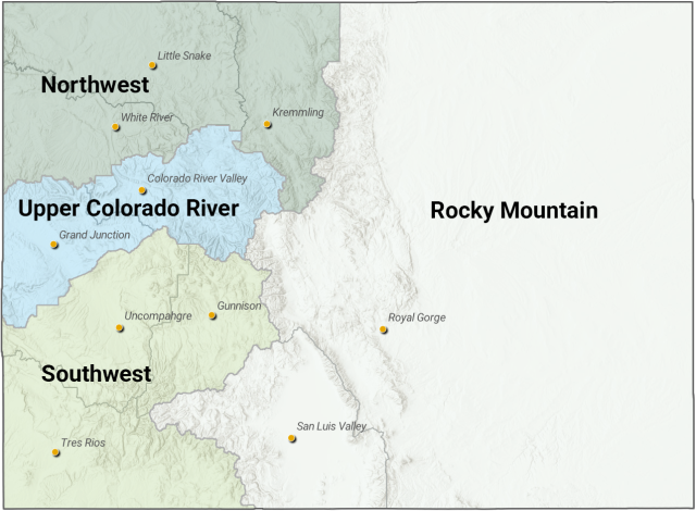
Northwest
- Kremmling Field Office
Restrictions
September 24, 2026: Stage 1 fire restrictions have been lifted. Only standard year-round wildfire prevention rules remain in effect.
Closures
There are no current temporary fire-related public land closures on BLM lands administered by this field office.
- Little Snake Field Office
Restrictions
September 11, 2026: Stage 1 fire restrictions have been lifted. Only standard year-round wildfire prevention rules remain in effect.
Closures
There are no current temporary fire-related public land closures on BLM lands administered by this field office.
- White River Field Office
Restrictions
August 31, 2026: Stage 1 fire restrictions have been lifted. Only standard year-round wildfire prevention rules remain in effect.
Closures
There are no current temporary fire-related public land closures on BLM lands administered by this field office.
Upper Colorado River
- Colorado River Valley Field Office
Restrictions
September 23, 2026: Stage 1 fire restrictions have been lifted. Only standard year-round wildfire prevention rules remain in effect.
Closures
There are no current temporary fire-related public land closures on BLM lands administered by this field office.
- Grand Junction Field Office
Restrictions
September 18, 2026: Stage 1 fire restrictions have been lifted. Only standard year-round wildfire prevention rules remain in effect.
Closures
There are no current temporary fire-related public land closures on BLM lands administered by this field office.
Southwest
- Uncompahgre Field Office
Restrictions
September 18, 2026: Stage 1 fire restrictions have been lifted. Only standard year-round wildfire prevention rules remain in effect.
Closures
There are no current temporary fire-related public land closures on BLM lands administered by this field office.
- Tres Rios Field Office
Restrictions
September 16, 2026: Stage 1 fire restrictions have been lifted. Only standard year-round wildfire prevention rules remain in effect.
Closures
There are no current temporary fire-related public land closures on BLM lands administered by this field office.
- Gunnison Field Office
Restrictions
September 18, 2026: Stage 1 fire restrictions have been lifted. Only standard year-round wildfire prevention rules remain in effect.
Closures
August 25, 2026: The BLM Gunnison Field Office reduced the footprint of its current temporary emergency closure in Ouray and Hinsdale counties. The revised closure now only prohibits public entry and use within these remaining areas:
- BLM-administered public lands north of the Bear Creek Trail and Ridge Stock Driveway to the boundary of U.S. Forest Service-administered public lands in Ouray and Hinsdale counties, including Sections 1 and 12 of T43 N., R7 W., and Sections 5, 6, 7 and 8 of T43 N., R6 W.
- BLM-administered public lands west of Colorado State Highway 149 to the boundary of U.S. Forest Service-administered public lands in Hinsdale County, including Sections 23, 26 and 35 of T45 N., R4 W.
- Revised closure order
- Revised closure map
Rocky Mountain
- Royal Gorge Field Office
Restrictions
September 21, 2026: Stage 1 fire restrictions have been lifted. Only standard year-round wildfire prevention rules remain in effect.
Closures
There are no current temporary fire-related public land closures on BLM lands administered by this field office.
- San Luis Valley Field Office
Restrictions
September 21, 2026: Stage 1 fire restrictions have been lifted. Only standard year-round wildfire prevention rules remain in effect.
Closures
There are no current temporary fire-related public land closures on BLM lands administered by this field office.
Levels of Fire Restrictions
Year-round regulations
Statewide, year-round fire restrictions are always in effect in Colorado. Unless permitted in writing by an authorized officer, visitors to BLM-managed public lands are prohibited from:
- Leaving a fire unattended or unextinguished.
- Possessing, discharging or using fireworks of any kind.
- Discharging a firearm using incendiary or tracer ammunition.
- Burning, igniting, or causing to burn any tire, wire, magnesium, or any other hazardous or explosive material.
- Operating any off-road vehicle on public lands unless the vehicle is equipped with a properly installed spark arrester pursuant to 43 CFR 8343.1 (c).
Stage 1 Fire Restrictions
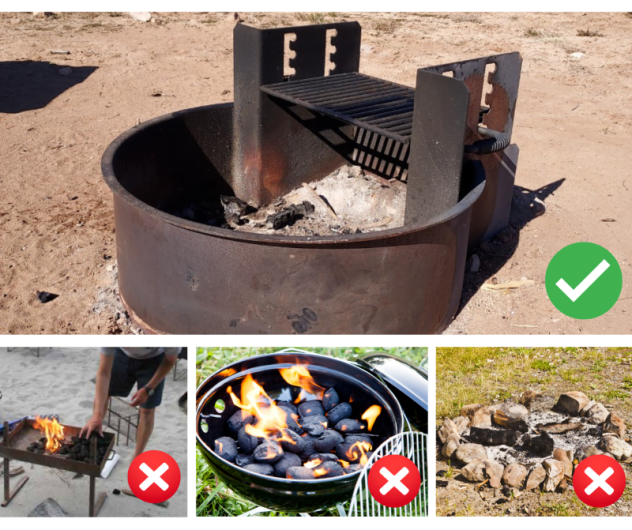
In addition to year-round wildfire prevention restrictions, the following are not allowed:
- Campfires are only allowed within designated fire grates in developed campgrounds (i.e. a metal, in-ground containment structure -- fire pans and rock campfire rings are not acceptable)
- No fires of any type including charcoal outside of developed areas. Devices using pressurized liquid or gas are exempted.
- No smoking except within an enclosed vehicle or building, a developed recreation site or in a barren area free of vegetation.
- No use of explosive materials, including explosive targets.
- No welding or operation of an acetylene or other similar torch with open flame except from an area that has been cleared of vegetation.
- No operation of any internal combustion engine without a spark arresting device properly installed and in working order.
Stage 2 Fire Restrictions
In addition to year-round wildfire prevention restrictions and stage 1 fire restrictions, the following are not allowed:
- No campfires or use of specific grills or stoves in any location. Building, maintaining, attending or using a fire or campfire, charcoal grill, coal, wood burning stove or sheepherders stove, including in developed camping and picnic grounds is prohibited. Devices using pressurized liquid or gas are exempted.
- No smoking, except within an enclosed vehicle, trailer or building.
- No use of an explosive requiring a fuse or blasting caps, fireworks, rockets, exploding targets and tracers or incendiary ammunition.
- No use of any internal combustion engine without a spark arresting device properly installed, maintained and in effective working order meeting either:
- (a) Department of Agriculture, Forest Service Standard 5100-1a; or
- (b) Appropriate Society of automotive Engineers (SAE) recommended practice J335(b) and J350(a). 36 CFR 261.52(j)
- No operation of a chainsaw without an approved spark arrestor, and without a chemical pressurized fire extinguisher and a round-point shovel with an overall length of at least 35 inches. The extinguisher will be with the equipment operator. The shovel may be kept with fueling supplies but readily available for use.
- No welding or operation of an acetylene or other torch with open flame.
- Keep campfires small and under control.
- Ensure that campfires are dead out. If it’s too hot to touch, it’s too hot to leave.
- Keep a shovel and water nearby to douse escaped embers.
- Do not park or idle vehicles in tall dry grass. The heat from the vehicle can spark a wildfire.
- Do not allow chains to drag from vehicles or towed trailers.
- Fireworks are never allowed on federally managed lands.