
Baaj Nwaavjo I’tah Kukveni-Ancestral Footprints of the Grand Canyon National Monument
A Window into the Wild
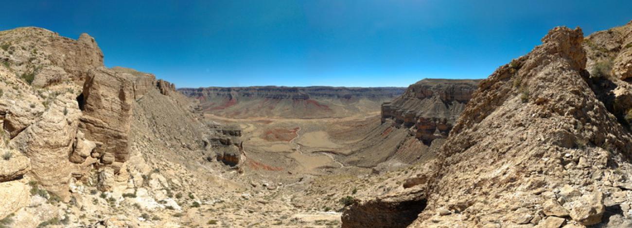
Nestled between the Grand Staircase, Vermilion Cliffs, and Pipe Spring national monuments to the north and Grand Canyon National Park to the south, the BLM-administered parcels of the Baaj Nwaavjo I’tah Kukveni-Ancestral Footprints of the Grand Canyon National Monument offer spectacular, 360-degree views of some of the West’s most remote and secluded landscapes ideal for experiences in solitude. The 529,242 acres to the north of Grand Canyon offer ample opportunities to unplug and tune into something bigger. Silence and distance lend to inspiration and discovery in these distant landscapes.
Visitors to the northwest and northeast parcels, will enjoy exploring varied topography from the curious formations of the Shinarump cliffs to the canyons and corridors that connect this landscape to the Colorado River. The monument gives way to views of mule deer that pass through this important migration corridor and glimpses of endangered California condors as they catch thermals with their nine-foot wingspan and soar over the expansive desert floor. The monument is also home to pinyon jays, golden eagles, tiger whiptail and desert horned lizards, pronghorns, ferruginous hawks, and western burrowing owls. In the spring a variety of plants add a hint of color to the landscape including orange globe mallow, white Apache plume, purple aster and crimson prickly pear while a lucky few may discover the endangered Brady’s pincushion cactus. Year round, the variety of plants across the north and east parcels from for four wing salt brush, Mormon tea, banana yucca, storksbill, wooly plantain, blue grama, or the indigo bush are illustrative of the range of ecological systems that make the monument so diverse.
Getting to the Monument
To safely explore the remote, undeveloped landscapes of the Baaj Nwaavjo I’tah Kukveni-Ancestral Footprints of the Grand Canyon National Monument, please visit the Interagency Public Lands Visitor Center, 4001 East Aviator Drive in St. George, Utah, 84790 or call 435-688-3200 to obtain maps, current weather and road conditions.
Visitor centers for the north and east parcels are located in St. George, Utah (BLM), Fredonia, Arizona (USFS) and Jacob Lake, Arizona (USFS, open seasonally).
To access the east parcel of the monument from Page, Arizona, travel south on Highway 89 to Bitter Springs. Then take Hwy 89A north, passing over the Navajo Bridge and the Colorado River to Marble Canyon and South House Rock Valley to explore this section of the monument.
To access the north parcel of the monument, from the BLM Visitor Center in St. George, Utah, travel north on Interstate 15 to Highway 9 east. In Hurricane, Utah, take Highway 59 to merge onto Hwy 389 to Colorado City and Fredonia, Arizona which will lead you to access points for the north parcel to the south of Colorado City and Pipe Spring National Monument.
Getting Around
The landscape across the monument is rugged, remote, and currently, largely undeveloped. Visitors should drive on existing motorized vehicle routes.
The northwest parcel is 42 miles southeast of the Public Lands Interagency Visitor Center in St. George, Utah; the northeast parcel is 60 miles southeast of the visitor center.
Visitor Activities
Scenic highway views of the monument can be found to the south along Hwy 59, 389 and 89A. The monument interior is best suited for four wheel-drive travel, hiking, wildlife and plant viewing, birdwatching, archaeological and historic site viewing, and geologic sightseeing.
Permits, Fees, Limitations
General visitor activities don't require any permits or fees.
Accessibility
There are no facilities within the monument.
Camping and Lodging
There are no developed campgrounds. The nearest lodging in Arizona is in Page, Marble Canyon, Jacob Lake or Colorado City. The nearest lodging in Utah is in St. George, Hurricane, Hildale or Kanab.
Food and Supplies
There are no services on site. The nearest food and supplies in Arizona are in Page, Marble Canyon, Jacob Lake or Colorado City and in Utah in St. George, Hurricane, Hildale or Kanab.
First Aid
There is no first aid station on site. The nearest hospitals are in St. George or Kanab, Utah, and Page, Arizona.
Your Safety
Before you explore this treasured and rugged national monument, take some time to plan your visit and make certain you are prepared with the proper equipment, maps and knowledge of the region. You will need to plan for potential hazards such as unmarked rugged roads, extreme heat, and flash floods. Bring plenty of water, food, extra gasoline, and at least two spare tires. We recommend high-clearance vehicles.
Road conditions vary based on weather conditions. Call ahead before coming to the monument. Obtain a map at the visitor center. Always carry extra water, food, matches or lighter, a signal mirror and foul weather gear. Technology can make backcountry travel more comfortable, but be aware that cell phones, radios and GPS units may not work in many areas. Instead, make sure you have a detailed map to find your way and leave a trip itinerary with friends or loved ones.
Conditions change seasonally and often suddenly. This is a beautiful but unforgiving landscape. You may encounter unexpected snowstorms, flash floods, lightning storms, impassable roads, extreme heat or cold, dried-up water sources and high water from floods or runoff.
Know who to contact in an emergency
For emergencies: call 911
Mohave County Sheriff's Office: 928-753-0753
Coconino County Sheriff’s Office: 928-774-4523
Kane County Sheriff’s Office: 435-644-2349
Monument Advisory Committee
The Baaj Nwaavjo I’tah Kukveni — Ancestral Footprints of the Grand Canyon National Monument Advisory Committee (MAC) is chartered in accordance with the Presidential Proclamation that created the Baaj Nwaavjo I’tah Kukveni — Ancestral Footprints of the Grand Canyon National Monument. The goal of the MAC is to provide advice and information to the Secretary of the Interior and the Secretary of Agriculture through the Bureau of Land Management and the U.S. Forest Service, relating to the development of the monument's management plan. The MAC may also, where appropriate, give advice on management of the National Monument.