Massacre Rim Dark Sky Sanctuary
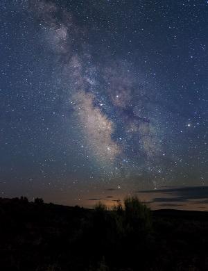
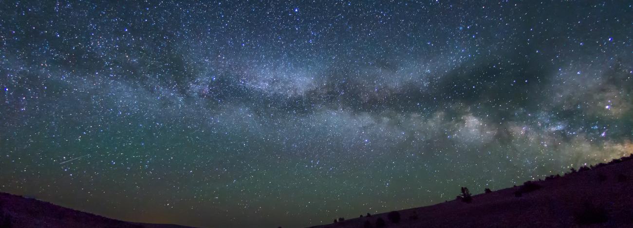
On March 19, 2019 the International Dark Sky Sanctuary Association named Massacre Rim in northwest Nevada one of the darkest places on Earth. The International Dark Sky Places Program was developed by the International Dark-Sky Association to promote dark sky preservation and to reduce light pollution through public education, policy, and lighting design.
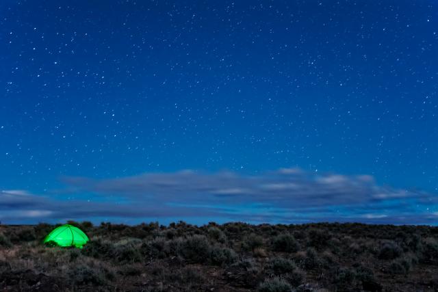
Located more than 150 miles north of Reno and surrounded by only a few small communities, the Massacre Rim Dark Sky Sanctuary suffers little from light pollution.
The topography allows for fantastic star-gazing opportunities: the Sanctuary encompasses two volcanic plateaus surrounded by wide valley floors. Along the western edge of the Dark Sky Sanctuary, the Massacre Rim, a 1,200 foot tall escarpment, descends dramatically into Long Valley.
The best star gazing happens in July when the Sagittarius and Scorpio constellations are their highest in the sky. The Perseids meteor shower, a prolific meteor shower associated with the comet Swift-Tuttle, is visible from mid-July each year. It peaks in early August when dozens of shooting stars are visible each hour.
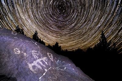
The Massacre Rim Dark Sky Sanctuary is located within the traditional territory of the Northern Paiute. The Massacre Rim derives its name from the steep escarpment along the western edge of the volcanic plateau and its proximity to the Massacre Lakes, a series of seasonally-dry lakes. Although the origin of the name “Massacre Lakes” is unknown, most likely, the name refers to stone markers under which weary travelers would bury their unneeded supplies. Later emigrants falsely interpreted these markers as graves.
HISTORY
Natural History
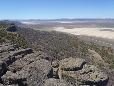
Representative of the volcanic history of the area. The Sanctuary is located on a volcanic plateau surrounded by seasonally dry lake basins to the west and south. The Massacre Rim, a steep 1,200-foot escarpment, is located along the western boundary of the Sanctuary. In a few places, basaltic flows cap previous rhyolitic flows; this is most evident on Painted Rock, a large hill just south of the Sanctuary. These flows date to the Miocene and are millions of years old.
Cultural History
Humans have inhabited the Massacre Rim area for over 10,000 years. The area contains numerous archaeological sites, including an astonishing number of prehistoric petroglyphs. The Massacre Rim Wilderness Study Area (WSA) is within the traditional territory of the Northern Paiute.
The WSA is located near the border between two bands of the Northern Paiute: the Kidütikado (Groundhog-Eaters) and the Aga’ipañinadökadö (Trout-Eaters). The traditional Aga’ipañinadökadö territory was focused on Summit Lake. The traditional Kidütikado territory was predominantly focused around Surprise Valley (in California), Big Valley (in Oregon) and Warner Valley (in Oregon), although areas in Long Valley, especially at the north end of the valley, were used for seasonal activities such as plant gathering and hunting. Deer, antelope, and bighorn sheep were hunted in the hills around Long Valley, while large groups of people would come together for rabbit drives on the valley floor.
Euro-American exploration of the region began in the mid-1800s. John C. Fremont, accompanied by Kit Carson, led an expedition that travelled through nearby High Rock Canyon in 1843. A few years later in 1846, the Applegate brothers, Lindsay and Jesse, together with Leon Scott, would establish the Applegate Emigrant Trail as an alternative route to the Willamette Valley in Oregon. The emigrant trail was used most frequently between 1846 and 1850, during the California gold rush, and then again from 1852 through 1869, after gold was found in Oregon.
Know Before You Go
- Know before you go
-
- Dispersed camping (camping outside of a designated campground) is permitted throughout the Sanctuary
- There are several campgrounds nearby on Bureau of Land Management (Applegate and Black Rock Field Offices), Sheldon National Wildlife Refuge, and Modoc National Forest that also provides dark sky viewing opportunities
- Practice Leave No Trace principles/ Pack It In-Pack It out
- Stay on established routes; off-road driving is prohibited within the Sanctuary
- Be careful driving at night- this area is open range and livestock (including black cows), horses, and wildlife may be on roads
- Two gravel highways (Nevada 8a and Nevada 34) are located near the southern and western boundary of the Sanctuary. Speed limit is 45 mph
- Roads within the Sanctuary are extremely rough and rocky; vehicles with 4wd, good clearance, good tires, and a spare tire are recommended for travel within the Sanctuary
- Check road conditions prior to travelling; the roads may not be passable, especially from November through May due to snow or mud
- Do not drive on playas (lake beds) when they are wet- you will get stuck. Know what to look for as it can often be wet just under the surface.
- Carry extra water; surface water in unreliable and must be treated
- The weather in the high desert is variable; be prepared for rapidly changing temperatures or conditions
- The Sanctuary is very remote. There is no cell service within or near the Sanctuary. The nearest gas stations are located in Cedarville, California, Gerlach, Nevada, and Denio, Nevada. These are approximately 40 to 90 road miles from the Sanctuary. Let someone know your itinerary and planned route for safety.
- Maps with roads can be bought at BLM Office in Alturas (708 West 12th St. Alturas, California, 96101) and at the Surprise Field Station in Cedarville (602 Cressler Street Cedarville, California, 96104)
- For information regarding Massacre and Stevens Camp cabins, contact the BLM Winnemucca District at 775-625-1500
- Star Gazing Tips
-
- Check fire conditions prior to travelling- smoke from other areas can obscure the night sky.
- Check weather conditions prior to going, as clouds can obscure the night sky.
- For a truly dark sky, plan your visit around new moons or when the moon sets early in the evening
- The Perseid meteor shower is visible from mid-July each year and peaks in early August.
- If you would like to remain on paved roads, nearby communities in Surprise Valley, California and Gerlach, Nevada also provide fantastic dark sky viewing opportunities.
- Flora and Fauna
-
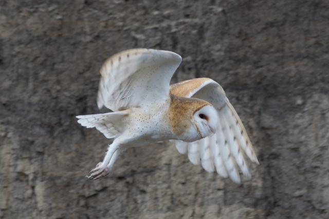
- Wildlife includes mountain lions, pronghorn antelope, mule deer, coyote, hawks, eagles, chuckers, quail, owls, rabbits, snakes, Greater sage-grouse, porcupine, pika, badgers, bats, and various rodents. Bighorn sheep were re-introduced to the area in the past few decades.
- Darkness, or rather the natural cycles of light, is an important resource for many of the wildlife species within the Sanctuary. Prey animals rely on the cover of darkness to elude predators and consequently some predators have adapted to hunt better in the dark or low-light conditions. In the Sanctuary area, this includes mountain lions, coyotes, badgers, owls, and bats. Other nocturnal animals within the Sanctuary, such as the kangaroo rat, forage for food at night to avoid the heat of the day.
- Light cycles can also influence mating rituals. The Massacre Rim Sanctuary is considered important Greater-Sage Grouse habitat. Each spring males from this species congregate early in the morning on leks and perform a “strutting display” for the females. Even natural “light pollution” can influence the duration of the strutting displays; it has been observed that a full moon may cast enough light to cause the male grouse to strut throughout the night, rather than just the early hours of the morning.
- Plants also are affected by light; artificial light can affect how long plants keep their leaves and prevent them from going into winter dormancy at the right time.