


Where the land meets the road: BLM turned 80 this year, as Route 66 turns 100
It has been written about in books, put into song, and shown on the big screen, but U.S. Route 66 has connections to federal public lands that deserve a starring role of their own.
Dubbed the “Mother Road,” Route 66 marks its centennial year Nov. 11. The Bureau of Land Management also celebrated a milestone this year — its 80th birthday in July. Throughout its 80 years, the BLM played a key role in the management of some public lands near this famous road.
While Route 66 begins in Chicago and ends in California, the BLM manages public lands surrounding the road in three states: Arizona, New Mexico, and California. Looking for a road trip adventure across America? Find information about three destinations on or near BLM-managed public lands, near Route 66, in each of these states as we celebrate 100 years of the iconic Mother Road.
Arizona
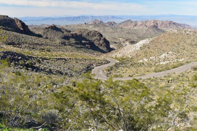
West of Kingman, Arizona, Route 66 turns into the BLM-managed Route 66 Oatman Road Back Country Byway. This 42-mile stretch of two-lane paved blacktop in Arizona is one of the best-preserved segments of the original Route 66. The byway passes between the Mount Nutt and Warm Springs Wilderness Areas, valleys, and Main Streets. Watch out for the hairpin curves of Sitgreaves Pass! Check out more information on the BLM webpage.
Mount Nutt Wilderness. In Mount Nutt Wilderness, more than 100 desert bighorn sheep are known to reside. Route 66 is located along the southern portion of the Wilderness boundary. The rugged terrain allows for following old vehicle routes, sand washes, and wildlife game paths including bighorn sheep and burros. Be sure to read important safety information about visiting this rugged wilderness on the BLM’s webpage.
The historic gold mining town of Oatman, Arizona, lies in the center of the southern half of the BLM’s Black Mountain Herd Management Area, along Historic Route 66. Fun fact: Free-roaming burros wander the streets of Oatman; these burros are thought to be the direct descendants from gold miners who brought them to the area as pack animals. An orphaned burro was even appointed the town’s honorary mayor. Beware, wild burros can bite. Find more information about wild burros in Arizona in the BLM brochure.
Find additional helping information about Route 66 in Arizona, in this Blog: “Celebrating 100 years of the 'Mother Road’ U.S. Route 66 in northwestern Arizona.”
New Mexico
The El Malpais National Conservation Area (NCA) Ranger Station sits nine miles south of Old Route 66. For more than 10,000 years, people have interacted with this landscape, which features dramatic sandstone cliffs, canyons, La Ventana Natural Arch, the Chain of Craters Back Country Byway, and the Cebolla and West Malpais Wilderness Areas.
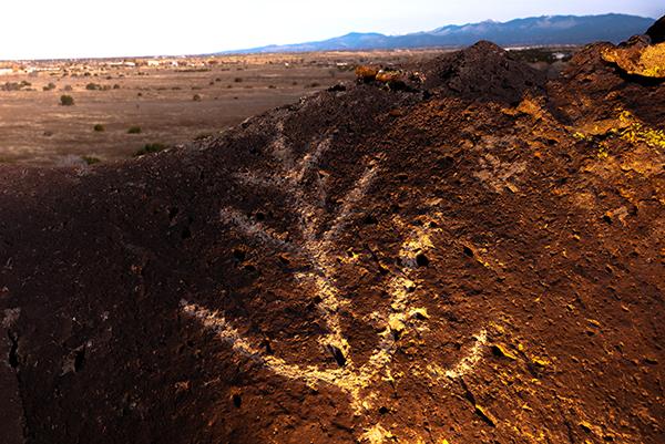
La Cieneguilla Petroglyphs offers short trails through a rugged basalt landscape dotted with hundreds of 13th–17th century carvings, including hump‑backed flute figures and varied bird imagery. This site is located 4.5 miles north of Old Route 66 and about 16 miles west of Santa Fe.
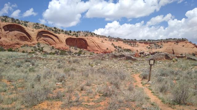
Four miles north of Old Route 66, Casamero Pueblo is a small Chacoan Outlier set against the dramatic red sandstone cliffs of Tecolote (Owl) Mesa. Look for the large 'owl's eyes’ that give the mesa its name and explore the site’s history through the interpretive signs around the ruin.
California
Historic Route 66 Needles to Barstow Scenic Byway. It may not be the infamous dark desert highway, but the byway is 178-miles-long through the Mojave Desert section of California Route 66 and follows segments of the National Old Trails Highway and the Santa Fe Trail. Be sure to visit the Historic Route 66 California Gateway Site Day Use Area, which memorializes the entryway of Historic Route 66 in California. The route also includes three WWII Desert Training Center camps.
Route 66 bisects the Mojave Trails National Monument. This Monument is a breathtaking mosaic of rugged mountain ranges, ancient lava flows, and sand dunes. The monument contains the longest remaining undeveloped stretch of Route 66.
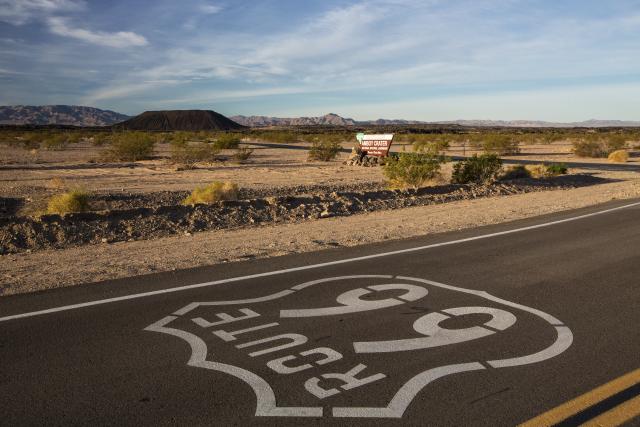
Amboy Crater National Natural Landmark. Amboy Crater, formed of ash and cinders, is 250 feet high and 1,500 feet in diameter. Fun fact: According to the San Bernardino County webpage, “In 1959, the volcano did “erupt” Hollywood style. The crater was used as a location for the movie “Journey to the Center of the Earth.”
Now that there’s some familiarity with BLM-managed public lands and related destinations along Route 66, let’s meet Neil Hamada, BLM California Recreation Planner, who traveled portions of Route 66.
‘Exploring America’
Three years ago, Hamada and his wife took a road trip down a portion of Route 66, from Needles, California, to Texola, Oklahoma. With no itinerary, they found joy in seeing where the road took them, driving about 750 miles of the nearly 2450-mile route.
Hamada noted the old Route 66 is broken up by modern freeways, but the original portions of the road are still there around the small communities.
“Do it without a plan,” Hamada recommends. “Take your time. Stay on the old Route 66, where you can, and visit the local communities and roadside attractions.
“That's what driving the old highway was about for my wife and I, exploring America. Not just the big attractions, but the small and unknown locations.”
Hamada said the people he met along Route 66 were eager to share the histories of their local communities.
The Hamadas stopped at the BLM-managed Casamero Pueblo in New Mexico, where they “looked at the red sandstone cliffs of Tecolote Mesa through a rock wall window, just as the Chacoan people did over 1,000 years ago.”
Tribal Connections
The BLM works with the American Indigenous Tourism Association (AIT) as a travel and tourism partner to support Indigenous tourism, cultural heritage, and greater awareness of tribal communities and destinations.
What is the connection between Route 66 and tribal communities? According to Gail Chehak, from American Indigenous Tourism Association, Inc.:
“Long before it became ‘The Mother Road,’ these pathways were ancient Indigenous trade routes, linking Native communities across the continent.”
So, while traveling Route 66, be sure to keep the following in mind, according to Chehak:
“Tribal Nations and Indigenous-owned business welcome visitors. They are happy to share their arts, culture, foods and way of life. It is very important that visitors traveling along Route 66 are conscious of the tribal lands and to be respectful of the land, plants and animals...We encourage visitors to ‘Leave No Trace’ and never remove anything from tribal lands.”
Route 66, A Century Later
As 100 years of the Mother Road is celebrated, people are encouraged to discover the old Route 66! Anyone traveling in the summertime should enjoy the luxury of their vehicle’s air conditioning — and be sure to appreciate what it took for an earlier generation of Americans to experience all the country has to offer, along the same well-traveled route.
Rhys Martin, Manager of the Preserve Route 66 Initiative, sums it up well:
"One of the most enduring images of Route 66 comes from the era of author John Steinbeck, who wrote the famous novel The Grapes of Wrath: a Model T overloaded with a family's belongings heading to California, seeking a better life during the Great Depression and the Dust Bowl. When those westward migrants approached the California border, they had to cross the Black Mountains in Arizona, which is today part of BLM-managed lands.
“Even in modern times, when travelers reach the California border, they are often shocked that crossing the Colorado River doesn't bring them immediately to a land of bounty. They must first contend with the Mojave Desert before reaching the so-called ‘promised land.’
“These public lands continue to tell stories of resilience. Although our travel capabilities have improved since earlier times, the landscapes surrounding Route 66 remain mostly untamed. The story of Route 66 is, therefore, the story of America—and without the BLM's work to balance our continued expansion West with the agency's multiple-use mission, we wouldn't have this enduring legacy to celebrate, 100 years later."
Resources
Public Law 106-45, (1999) authorized the Secretary of the Interior, acting through the National Park Service, to provide assistance for preservation of cultural resources along the Route 66 corridor.
Related Stories
- Manatee Awareness Month: Protecting Gentle Giants at the Jupiter Inlet Lighthouse Outstanding Natural Area
- Ryan GosWING Wins BLM’s 2026 Bat Beauty Contest
- BLM Partners and Volunteers Enhance Desert Garden at San Pedro Riparian National Conservation Area
- BLM’s Meadowood Special Recreation Management Area Celebrates 25th Anniversary
- Celebrate Halloween with Bat Trivia on BLM-Managed Lands