El Malpais National Conservation Area | New Mexico
BLM Rio Puerco Field Office Hosts National Public Lands Day Volunteer Event
Join the Bureau of Land Management for National Public Lands Day and to celebrate America’s 250th anniversary by volunteering at El Malpais National Conservation Area on September 26!
The El Malpais National Conservation Area (NCA) was established in 1987 to protect nationally significant geological, archaeological, ecological, cultural, scenic, scientific, and wilderness resources surrounding the Zuni-Bandera volcanic field. El Malpais translates to "the badlands" in Spanish.
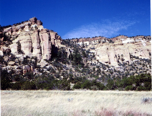
The NCA features dramatic sandstone cliffs, canyons, La Ventana Natural Arch, Chain of Craters Back Country Byway, Joe Skeen Campground, the Narrows Picnic Area, and the Cebolla and West Malpais Wilderness Areas – offering exceptional opportunities for photography, hiking, camping, and wildlife viewing.
For more than 10,000 years, people have interacted with the El Malpais landscape. Historic and prehistoric sites provide connections to the past. These cultural resources remain alive through the spiritual and physical presence of contemporary Indigenous peoples, including the Ramah Navajo and Puebloan peoples of Acoma, Laguna, and Zuni, who continue their ancestral uses of El Malpais, including gathering plant materials, paying respect, and renewing ties to this land.
Visitors should exercise caution during the monsoon season due to unpredictable weather and flash flooding. All visitors should come prepared with water, sturdy hiking boots, snacks, rain gear, a first aid kit, and sunscreen. Exploring BLM lava tube caves requires warm clothing, protective headgear, three sources of light, and leather gloves.
Volunteer camp host applications are accepted year-round. Please email [email protected] or [email protected] if interested.
El Malpais National Conservation Area Community Art Program
The Public Lands Interpretive Association and the Bureau of Land Management invited artists from El Malpais' surrounding areas to participate in a unique collaboration – weaving together art, land stewardship, history, culture, and conservation. This project celebrates local artists while preserving the history of El Malpais NCA for generations to come. We hope visitors will enjoy the artwork on display while deepening their appreciation for the remarkable resources of this area of the New Mexico landscape.
Join the Adventure at El Malpais NCA!
The El Malpais NCA Junior Ranger Guide explores the history, culture, geology, and natural resources of the area through engaging educational activities, including word games, logic puzzles, and coloring activities. Download the guide to print at home, or request to have a copy mailed to you by calling the Rio Puerco Field Office at 505-761-8700.
Once completed, take the oath with an onsite Ranger at El Malpais NCA, become an official El Malpais Junior Ranger, and receive your badge! If you are unable to complete the guide on site, mail your completed booklet to 100 Sun Ave NE, Suite 330, Albuquerque, NM 87109 and we will mail your patch to you!
Accessibility Description (ABA/ADA)
- The BLM Ranger Station, Joe Skeen Campground, and South Narrows Picnic Area all have benches and restroom. Potable water is available at the BLM Ranger station - at the red spigot out front and inside the station.
- El Malpais National Conservation Area includes several Wilderness Areas with no developed facilities. Wilderness Areas are designated for their unique wilderness characteristics, primitive recreation opportunities, solitude, and largely undeveloped areas.
- There are no facilities or interpretive signage to aid navigation.
- There are no established trails. Pathways consist of uneven roads, paths, or cow trails. Visitors must be able to walk, scramble, and/or cross flowing water while exposed to the elements.
Know Before You Go
Facilities:
El Malpais Ranger Station
- Open Friday through Sunday, 8:30 a.m. to 4:30 p.m.
- These hours are subject to change due to staffing availability.
Joe Skeen Campground
- Open year-round with 10 free first-come, first-served campsites (no reservation).
- Each site includes a covered picnic table, fire grill, and tent space. Some sites offer pull-through parking, accommodating vehicles up to 50 feet.
- There are two vault toilets.
- No water is available at the campground.
- There is a maximum of 15 people and 2 vehicles per campsite.
- There is a limit of 7 days campsite occupancy in any 28-consecutive-day period.
- The road is graveled and passable in most conditions. Wait for arroyo water to dissipate before crossing.
- Horses and other pack animals are not allowed in the campground.
- Quiet hours are between 10 p.m. to 6 a.m.
Hole-in-the-Wall
- A premier destination for avid hikers and backpackers, Hole-in-the-Wall is 6,700-acre kīpuka – a rare island of ponderosa pine forest and open rangeland surrounded by lava.
- Accessing Hole-in-the-Wall requires hiking several miles across open plains and lava flows. This is a designated Wilderness Area and is not accessible by bicycle.
- Please pack in plenty of water, as there are no reliable water sources in the area.
- Read more about Hole-in-the-Wall
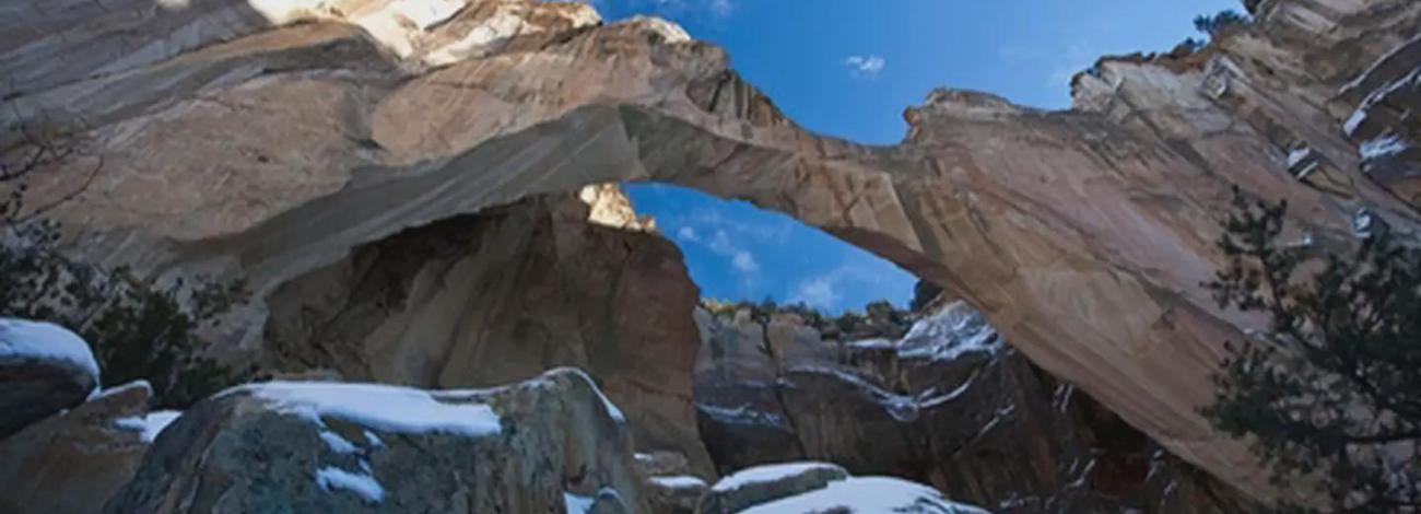
La Ventana Natural Arch Recreation Area
- A quarter-mile trail leads to the base of La Ventana, one of New Mexico’s largest natural arches. Restrooms are available at the trailhead.
- The trail transitions from paved to primitive as you enter the federally designated Cebolla Wilderness, surrounded by dramatic sandstone cliffs, piñon and juniper trees, and native shrubs and grasses. Please stay on the trail and help protect our fragile resources.
- Overnight camping and rock climbing are strictly prohibited.
South Narrows Picnic Area:
- Features 6 covered picnic tables with fire grills and 2 vault toilets.
- Open sunrise to sunset. Overnight camping is not permitted.
- The Narrows Rim Trail begins near the entrance at the south end of the picnic area, climbing to the top of a 500-foot sandstone mesa, with scenic views of the lava beds and surrounding landscape. The trail ends with a spectacular view of La Ventana Natural Arch. Approximately 8 miles round trip. This trail is part of a designated Wilderness area and is not accessible by bicycle.
- Read more about the Narrows Rim hike. Take a virtual tour of the Narrows Rim Trail and Picnic Area.
Dittert Site:
- The Dittert Site is a pueblo ruin located at the mouth of Armijo Canyon. This pleasant, sandy 4.5 mile hike winds through piñon and juniper trees to a well-preserved Pueblo ruin and homestead.
- This is a designated Wilderness Area and is not accessible by bicycle.
- Read more about the Dittert Site.
Continental Divide National Scenic Trail:
- The trailheads along CR 42 provide access to the 3,100-mile National Scenic and Historic Continental Divide Trail, which follows the continental divide from Mexico to Canada. This section winds among the Chain of Craters and through piñon, juniper, ponderosa pine, and a variety of shrubs and grasses. The trail runs approximately 20 miles between two trailheads along CR 42.
- No reliable water sources exist in the area – pack plenty of water.
- CR 42 is a dirt road and is impassable when wet. Check weather conditions before heading out.
Wilderness and Wilderness Study Areas:
- El Malpais National Conservation Area hosts a myriad of designated Wilderness Areas and Wilderness Study Areas, which allow visitors to experience primitive recreation, solitude, and breathtaking landscape. Find out more about wildernesses in El Malpais below:
National Parks Service El Malpais National Monument
For information on the Sandstone Bluffs Overlook, Acoma-Zuni Trail, the Lava Falls Area, Big Tubes Area, or general cave exploration, please visit the National Park Service website.
Nearby Amenities
The nearest location to acquire food, gas, and water is in Grants, ~27 miles away via NM-117 W and I-40 W.
Season/Hours
Open year-round.
- Use may be restricted periodically due to fire dangers or other management needs.
Special Rules
- Total stay in the NCA is limited to 14 days per month.
- No livestock or horses are permitted in the campground.
- Quiet hours are from 10:00 PM to 6:00 AM.
- Stay is limited to 7 days per month in the campground.
- No fireworks or firearms can be discharged in the campground.
- Hunting is prohibited within ½ mile of the campground and other developed recreation sites.
- Collecting firewood and any other natural or historic object is prohibited.
- Check with local authorities for open fire regulations for each day.
Brochures, Maps, and Publications
Contact Us

Activities


Addresses
Directions
Two state highways provide access to the NCA from I-40. Exit 89 (east of Grants) takes you along NM Highway 117, providing access to the BLM Ranger Station, several developed recreation sites, and Cebolla Wilderness. Exit 81 (west of Grants) takes you along NM Highway 53, providing access to Continental Divide Trail trailheads, West Malpais Wilderness, Hole-in-the-Wall trailhead, and El Calderon (National Park Service).
BLM Ranger Station
Located 9 miles south of I-40 Exit 89 on NM Highway 117. 906 NM-117, Grants, NM 87020. The above GPS coordinates correspond to this location. (505) 280-2918
El Malpais National Monument Visitor Center (National Park Service)
1900 E Santa Fe Ave. Grants, New Mexico 87020. (505) 876-2783.
Continental Divide National Scenic Trail
From NM Highway 53: Drive southwest from NM Highway 53 to County Road (CR) 42. Turn south on CR 42 and continue approximately 5 miles to the trailhead. Parking is available at the trailhead, and the trail is marked with a rock cairn across from the parking area.
From NM Highway 117: Drive south on Highway 117 until you reach CR 42. Continue approximately 9 miles on CR 42 to the trailhead. Parking is available at the trailhead, and the trail is marked with a rock cairn adjacent to the parking area.
Dittert Site
To reach the Dittert Site, drive south on NM Highway 117 for 22.6 miles until you reach CR 41, also known as Pietown Road. Head south on CR 41 for approximately 3.7 miles until you see the Armijo Canyon sign on the east side of the road. Turn left and continue approximately 1.5 miles to the parking area and trailhead.
Weather Notice: CR 41 and the road leading to Armijo Canyon may become impassable when wet. Check weather conditions before heading out.
Hole-in-the-Wall
Drive south on NM 117 until you reach CR 42, also known as Chain of Craters Backcountry Byway. Turn onto CR 42 and proceed northwest for approximately 2.1 miles to a fork in the road. Take a right and continue north for approximately 5 miles to the trailhead.
Weather Notice: CR 42 is a dirt road and becomes impassable when wet. Check weather conditions before heading out.
Fees
No Fees
Stay Limit
Photo Album