
Casamero Pueblo |
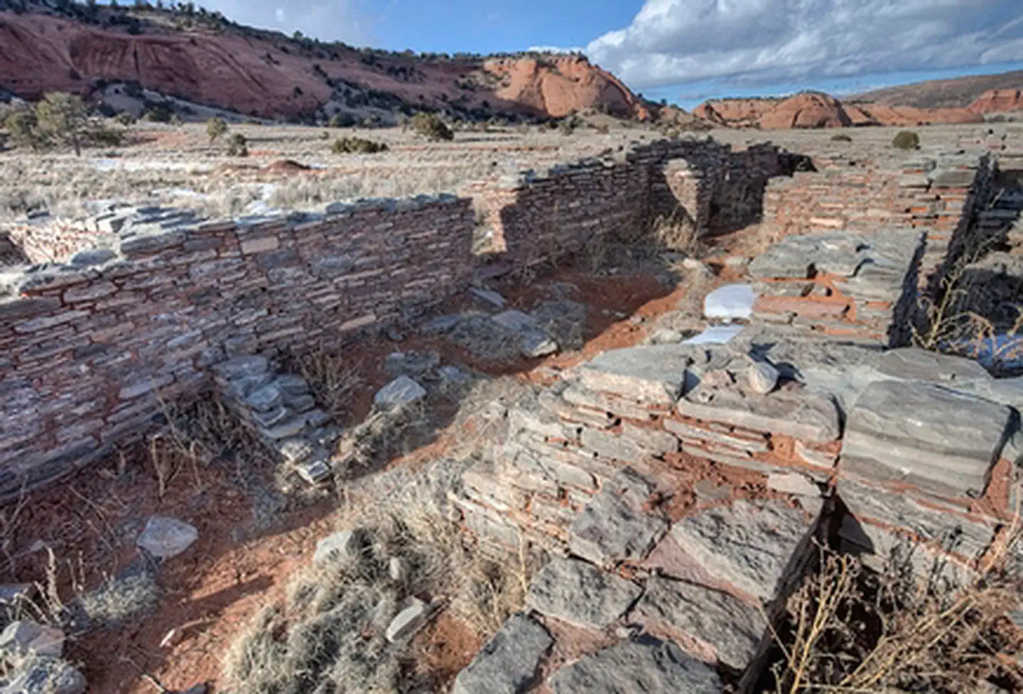
Casamero Pueblo is small Chacoan Outlier located against the majestic backdrop of the brilliant red sandstone cliffs of Tecolote (Owl) Mesa. Look for the large "owl's eyes" that give the mesa its name. The pueblo contains 22 ground floor rooms and may have had six second-story rooms. It was occupied between A.D. 1000 and 1125 and is an excellent example of a Chacoan Outlier, with characteristic core-veneer masonry, an associated Great Kiva, and two Chacoan roads. A collection of 37 known sites is associated with Casamero and includes numerous small masonry habitation structures. A Chacoan road connects Casamero to the nearby outlier of Andrews Ranch. Foods grown and pottery produced in the Casamero community may have been traded to other outliers and to Chaco Canyon itself. Casamero was excavated between 1966 and 1967 and has since been completely stabilized so that the Chacoan masonry and the site layout are clearly visible to the public. Interpretive signs have been placed around the ruin.
Photos
Accessibility Description (ABA/ADA)
- The small dirt parking area has a trail that leads to the Casamero Pueblo Ruins, it is a shoulder-width dirt path that is relatively level and has a slight incline right before the ruins. The ruins are a historic site with no ADA-compliant features.
- The path can get overgrown at times with weeds and sunflowers. If this is the case, look for the ruins and black interpretive signs off to the right of the trail.
- To navigate the trail and ruins visitors need to be walk across uneven dirt, through weeds, and around crumbled sections of ruins.
Know Before You Go
Fees
- None.
Facilities
- There is no potable water or restrooms available.
- There is a small dirt parking area at the trailhead with a short trail to access the Casamero Pueblo ruins.
- There are several informative signs around the ruins.
Nearby Amenities
- The nearest location to obtain gas, food, and water is in Thoreau, ~16 miles away via Co Rd 19 and I-40 W.
Season/Hours
- Open year-round.
Special Rules
- Motorized use of the trail is prohibited.
- No fireworks, discharge or use of firearms, or any other weapons in the area.
- Please do not remove or damage archaeological resources. Even small pottery sherds found on the surface can establish the time period when this site was occupied.
- The Antiquities Act of 1906 and the Archeological Resources Protection Act of 1979 make it illegal to excavate, remove, damage, or deface archaeological resources. Penalties of up to five years in jail and a $250,000 fine can be imposed.
- Pets must be on a 6-foot leash and their waste disposed of.
- Practice Leave No Trace. Please make sure to carry out or dispose of any litter.
Brochures, Maps, And Publications
- N/A
Wildlife in Area
- Horned lizard
- Red-tailed hawks
Flickr Album

Contact Us
This site is managed by Farmington Field Office; visit their page for office hours and directions.

Activities


Addresses
Farmington Field Office
6251 College Blvd A
Farmington
New Mexico
87402
Directions
To reach Casamero Pueblo, take the Prewitt exit from Interstate 40, 19 miles west of Grants or 40 miles east of Gallup, NM. From the exit, go a few hundred feet north to the frontage road. Head east on the frontage road (Old Route 66/NM 122) for about 1/2 mile, then north on County Road 19, and continue 4 miles to a small parking area with a BLM sign on the left. A short foot trail leads to the ruins.