
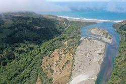
BLM and Partners Complete Lower Mattole River and Estuary Restoration Effort
By Zane Ruddy, Fish Biologist, Arcata Field Office
through the Bureau of Land
Management’s King Range
National Conservation Area.
Photo by Hugh McGee.
The lower Mattole River and estuary had become a barren channel lacking vegetation, leaving habitats sparce and unfavorable for wildlife, including salmon and steelhead. With the help of our longstanding partners at the Mattole Restoration Council (MRC) and Mattole Salmon Group (MSG), teams recently completed a decade-long effort to restore three miles of the lower Mattole River and estuary within the King Range National Conservation Area.
From 2012 to 2021, more than $3 million in grant funds were awarded to implement an array of projects aimed at improving the health of the ecosystem, with a focus on habitat for imperiled Chinook salmon, coho salmon, and steelhead. In total, 1,800 feet of estuary slough channels were excavated and connected to the river, 900 trees were added to the river creating log structures to increase habitat complexity, and 15,000 willow cuttings and 17,000 native plants were planted to add integrity to previously barren river islands and terraces. All trees used for the project came from nearby conifer encroachment prairie restoration projects, all willow cuttings came directly from the project site, and all native plants were grown at the MRC’s nursery.
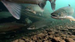
ground for adult steelhead prior
to their journey upstream to spawn.
Photo by Thomas Dunklin.
Based on post-project monitoring and accounts from those that know the area best, improvements to habitat and overall ecosystem health are tangible. “When I first started working in the lower Mattole River in 2007, there was little vegetation within the channel and almost no channel stability, it felt like walking through a desert,” said Conor Shea, a project team member and hydrologist with the U.S. Fish & Wildlife Service. “Now, when I visit the Mattole River, I no longer see a desert. I see vegetated islands, new growth coming in, deeper pools, and increased habitat for salmon and steelhead.”
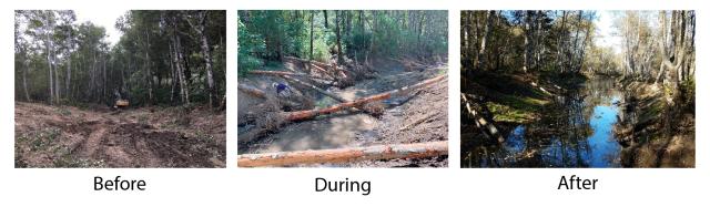
winter storms.The completed slough channel is 1,800-ft long. A restoration worker
installs wetland plants in a section of the newly excavated slough channel. Photos by
Hugh McGee and Zane Ruddy.
The project’s success is in large part due to the frontloaded efforts of the BLM-led technical advisory committee (TAC). The TAC, which consisted of state and federal agencies, restoration practitioners, and local landowners, developed a flexible plan that resulted in a variety of “shovel-ready” projects. The BLM took on the environmental compliance workload, which allowed the MSG and MRC to focus on their strengths — grant writing and restoration project implementation.
Learn more about the Mattole River Estuary project.
Photos courtesy of Zane Ruddy, Hugh McGee, and Thomas Dunklin.
Related Stories
- Planting for the Future: BLM Staff and Volunteers Rebuild the Jupiter Inlet Lighthouse Shoreline
- BLM and Partners Celebrate America's 250th at the King Range National Conservation Area
- Birding Aravaipa Canyon: A morning of songs, color, and creekside adventure
- BLM Celebrates America’s 250th Anniversary in Oregon
- Reel Partners: BLM and Wyoming Game and Fish Cast a Line for Kemmerer’s Next Generation