
PFYC: A Rapid Assessment Tool for Paleontology
Story by: Andrew Smith, Cartographic Tech; and Greg Liggett, Paleontologist; Montana/Dakotas State Office
For many years, the BLM has been using Potential Fossil Yield Classification (PFYC) as a tool to predict impacts to fossil resources from planned actions.
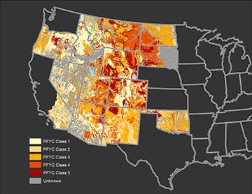
Classification dataset.
Graphic by Andrew Smith, Cartographic Tech
The basis of the system is straight-forward: some rock units are more likely to contain scientifically interesting fossils than others. This assessment can be made by rock type and recorded discoveries of fossils. The system is a simple, ranked from 1 (very low potential) to 5 (very high potential) scale, with a ‘U’ category for unknown or understudied areas.
Effective use of the system requires the best quality geologic maps. For several years, BLM paleontologists have been standardizing the fields for a geodatabase as well as a GIS workflow and product. The fruits of these efforts are beginning to emerge.
Working state-by-state, sometimes with partner cooperators, we have gathered the highest scale geologic maps in GIS form and put them together. In some places, the best available map is at 1:500,000 scale, which is not ideal. In other places, maps were produced at 1:24,000 scale or higher, which provide greater detail. Combining these various scales creates a mosaic of the best available resolutions.
Every mapped unit was then assessed for its PFYC rank, and scripts were developed to help make populating the attribute tables easier. We now have several states done and the data is available to the public, as well as BLM employees, contractors, and partners.
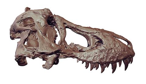
skulls ever found. It was discovered in 2016 on BLM land in the
badlands of Montana by Burke Museum of Natural History volunteers
Luke Tufts and Jason Love. The PFYC tool may help researchers
locate additional dinosaur specimens.
Digital scan by Triebold Paleontology
Data for the following states have been posted: Alaska, Colorado, Montana, Nevada, North Dakota, Oregon, South Dakota, Utah, and Wyoming. Arizona, Idaho, New Mexico, Oklahoma, and southern California will be added soon. Work is underway on more states which will be included as they are completed. Each state has two features; one shows the color-coded PFYC values for the rock units, and one shows the maps used to compile the data.
These data sets will greatly improve assessment of projects on fossil resources, increasing the speed of analysis. As additional geologic maps become available the data sets will be updated as time allows.
How to access the National PFYC Dataset
The PFYC is available to the BLM and the public in two formats: a layer file map service and a file geodatabase. The layer file map service allows the user to either view the data in their browser through ArcGIS Online or connect to the layer file from ArcMap or ArcGIS Pro. This layer file is linked to the BLM Hosted Service and will update as changes are made to the dataset. While attribute data is available through the ‘Identify’ tool, a full attribute table is not included in the connected layer file.
By downloading the file geodatabase, the user can modify the data to suit their needs in ways that are unavailable to layer files (e.g., clipping the extent to a project area or selecting specific units from the attribute table). State data administrators might wish to clip the data to their state and host the data in their Corporate Data folder structure. After downloading, this geodatabase is disconnected from BLM hosted servers and will not be updated as data is added or modified. Both file formats can be accessed from the following link:
https://gis.test.blm.gov/arcgis/rest/services/geophysical/BLM_Natl_PFYC/MapServer
Related Stories
- Dino-Mite Story Time in Pinedale
- Reel Partners: BLM and Wyoming Game and Fish Cast a Line for Kemmerer’s Next Generation
- Preserving a Legacy in Stone: The Race to Save Pompeys Pillar
- BLM Billings Field Office Completes Dilworth Creek Riparian Restoration Project
- Boating Paradise: GAOA Funding Enhances Popular Recreation Site Along Montana’s Yellowstone River