
Armchair Adventures
America’s public lands offer some of the most spectacular and interesting places you’ll ever see. While everyone is encouraged to stay at home, the BLM Blog will feature "Armchair Adventures." This is your opportunity to travel virtually and learn a bit about these amazing places. Today, follow along with the fifth installment of Armchair Adventures.
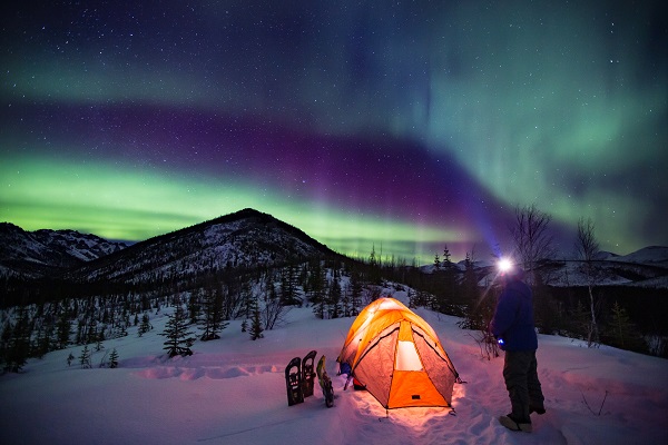
White Mountains Aurora, Alaska
Alaska’s White Mountains, located north of Fairbanks, are ground zero for some of the best Aurora Borealis viewing on earth. Descriptions of the aurora, or the northern lights, go as far back as written history. Early theories included sunlight reflected by ice crystals in the air, the glow of glacier ice, or a light emanating from the edge of Earth. By the eighteenth century, scientists discovered a connection between the aurora and disturbances in Earth’s magnetic field, but it has only been over the past 30 years that processes creating the aurora and its colors have become more fully understood.
The light of the aurora is generated by atoms and molecules of the air when they are struck with energetic particles from space. The particles come in various intensities based on solar activity. They generally only travel along the direction of the magnetic field, which shapes the aurora into moving curtain and ray-like shapes.
Aurora colors are determined be the altitude where they originate and the atmospheric molecules the magnetic particles energize. Most particles charge oxygen molecules creating green – the most common color we see. Blue and purple are less frequently seen and are caused by collisions with Nitrogen molecules. In this image, the aurora shines green with hints of purple.
The Alaska aurora-viewing season will soon be winding down for late spring and summer, as the nights keep getting shorter. Soon, it won’t be dark enough for the aurora to be visible there. However, during the strongest magnetic storms, residents of the lower 48 states may be treated to glimpses of this natural spectacle during summer. The University of Alaska maintains an aurora-forecasting site at: https://www.gi.alaska.edu/monitors/aurora-forecast
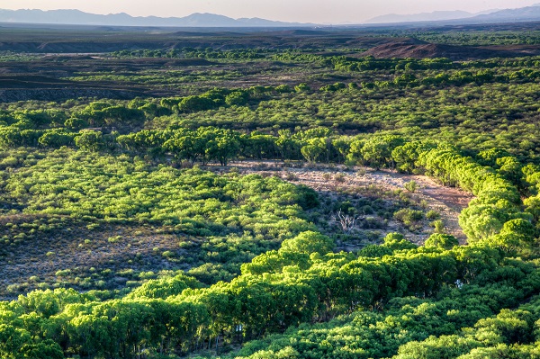
San Pedro River, Arizona
The San Pedro River in Southern Arizona is truly a desert oasis. In springtime, the explosion of lime green leaves on the cottonwoods and willows makes it a bit more challenging to spot some of the 250 bird species that winter or migrate along the river corridor. As spring progresses the migratory bird songs will be replaced by those of the 100+ species of nesting birds and their newly hatched chicks.
The San Pedro meanders through a transition zone between the Chihuahuan and Sonoran Deserts and also attracts over 80 species of mammals including coati, javelina and beaver. Petroglyphs and earlier cultural remnants indicate that humans have been using this rich riparian corridor for at least 13,000 years.
The area’s more recent cultural history is evidenced by remnants of the Spanish Presidio Santa Cruz de Terrenate, a fortress marking the northern extension of New Spain into the New World. This was one of a chain of similar presidios that extended to Louisiana in the east and California in the west. The presidio suffered from internal corruption and low morale and repeated attacks of the Apache Tribe, and was finally abandoned in 1780. One-hundred years later the railroad arrived and the town of Fairbank sprang up as an important depot and jumping off spot for its infamous nearby neighbor of Tombstone. The BLM works in cooperation with non-profit groups to maintain and interpret these historic resources.
Over 40 miles of the San Pedro are under BLM Stewardship and were designated by Congress as the San Pedro Riparian National Conservation Area.
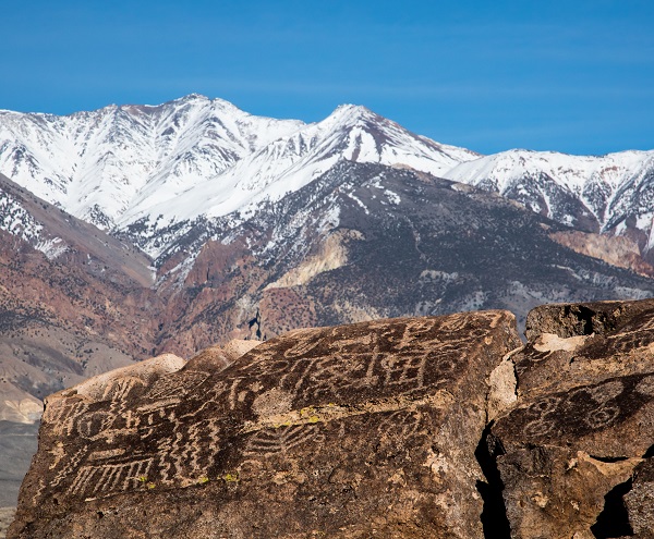
Volcanic Tablelands Petroglyphs, California
The Volcanic Tablelands are Located at the northern edge of California’s Owens Valley. They are part a large area covered by a series of volcanic ash flows from the eruption of the Long Valley Caldera, near Mammoth Mountain. The main eruption occurred 760,000 years ago resulting in pumice layers up to 600 feet deep.
Around 8,800 years ago, the people who inhabited the area began pecking designs into the dark surface layer of the area’s volcanic rocks. These petroglyphs were chipped out of the rock surface as opposed to pictographs that were painted on rock surfaces. The exposed inner rock lacks the darker oxidation of the exterior and provides the contrast that makes the designs visible. Since the re-oxidation of the surface takes many thousands of years the designs remain visible today.
The meaning of the symbols is not absolutely clear. Individually, some objects are recognizable as deer, bighorn sheep, human figures, and birds. Other symbols include lines, grids, and concentric circles in different configurations. The purpose to these designs might have been ceremonial, practical, functional, or an artistic expression. Use your imagination. . .
In this view, White Mountain Peak, at 14,226 feet, towers 10,000 feet above the petroglyphs and is the tallest mountain in the Great Basin.
Related Stories
- BLM law enforcement medical rescue team brings advanced care to public lands
- Meet Kyle Voyles, BLM National Cave and Karst Program Lead
- More time travel for the nation’s 250th: Exploring BLM back country byways in Oregon and California
- Voyages of discovery for the nation’s 250th: Exploring America’s landscapes on BLM back country byways
- Artist in Residence celebrates ‘place of special value’ in southwest Colorado