
Armchair Adventures
America’s public lands offer some of the most spectacular and interesting places you’ll ever see. While everyone is encouraged to stay at home, the BLM Blog will feature "Armchair Adventures." This is your opportunity to travel virtually and learn a bit about these amazing places. Today, follow along with the first installment of Armchair Adventures.
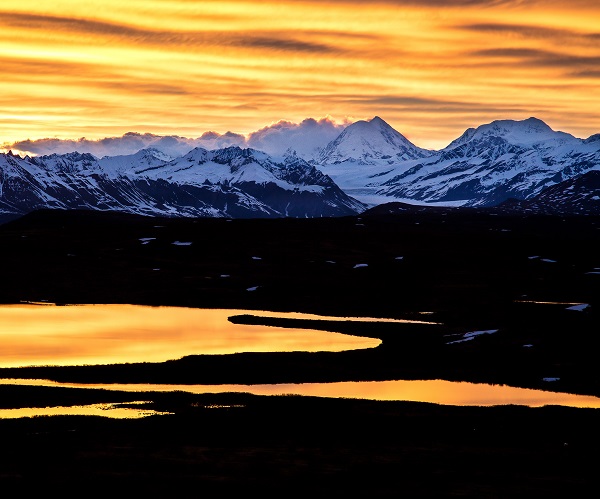
Mount Hayes, Alaska
The Denali Highway parallels the southern flank of the Alaska Range and was the old route from Anchorage to Denali National Park. This mostly gravel road offers spectacular views around every turn. About 150 miles of Denali, glacier-clad Mount Hayes is the highest peak in the eastern Alaska Range at 13,832 feet. Although numerous peaks in Alaska and the lower 48 are higher in elevation, Mount Hayes is one of the largest peaks in terms of rise above local terrain. Hayes rises over 11,000 feet above the surrounding terrain in this southern view from Maclaren summit. In terms of topographic prominence, Mount Hayes Ranks 51st in the world. This image was taken around the time of the summer solstice at about 1 AM. Although the Alaska Range is south of the Arctic Circle, summer nights are made up of hours of twilight.
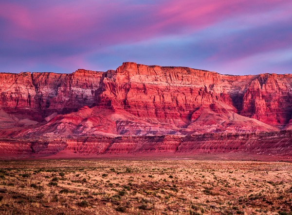
Vermilion Cliffs, Arizona
Today takes us to the aptly named Vermilion Cliffs managed by the Bureau of Land Management - Arizona. It's located north of the Grand Canyon, parallel to the Utah-Arizona border. These foreboding steep walls of rock rise as much as 3,000 feet above their bases. The sandstone and other sedimentary rocks gain their rich red-vermilion colors from iron oxide pigments. Moisture bonds with the iron in a process that is the same as rust forming on a piece of metal. Lighter bands of rock contain less iron while other minerals in smaller quantities produce additional colors such as blue from manganese. The warm colors are almost surreal at sunrise and sunset.
More than twenty species of raptors, including bald eagles and golden eagles, peregrine falcons, and several hawk species use the area. The cliffs are also the site of a succeeding effort to reintroduce California Condors to the greater Grand Canyon region. Desert bighorn sheep, pronghorns, and mountain lions make up most of the large mammals found here, with about 30 more species of smaller mammals. Although they are a rare commodity in this arid landscape, area streams contain several examples of rare fish species, such as the flannelmouth sucker and the speckled dace.
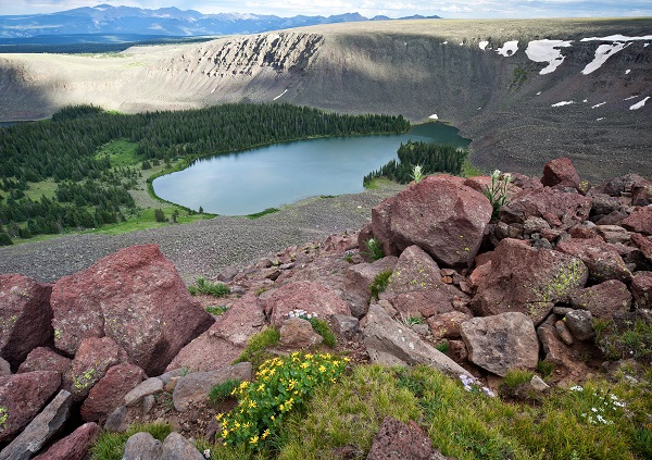
Powderhorn Lakes, Colorado
The Powderhorn Lakes are nestled below the Cannibal Plateau which at 12,700 ft. is likely the largest expanse of flat alpine tundra in the contiguous United States. Located at the northern edge of the San Juan Mountains, this is a relatively dry area by Colorado alpine standards and contains sagebrush meadows strewn with several glacial cirque lakes. Elk and mule deer roam the plateaus and pass through the stands of aspen, pine, spruce, and fir that blanket the lower elevations.
The area’s namesake Cannibal Plateau comes from the infamous “Colorado Cannibal" Alfred Packer. A prospector and self-proclaimed professional wilderness guide, Packer confessed to cannibalism during the winter of 1874. He and five other men attempted to travel through the region during the peak of a harsh winter. When only Packer returned to civilization, he eventually confessed that the party had resorted to cannibalism to stay alive when they became lost and stranded. He changed his story several times stating self-defense and other reasons for deaths of party members. Packer escaped from jail and eluded justice for nine years before being tried, convicted of murder, and sentenced to death. Packer won a retrial, and was eventually sentenced to 40 years in prison, on five counts of voluntary manslaughter.
Related Stories
- BLM law enforcement medical rescue team brings advanced care to public lands
- Meet Kyle Voyles, BLM National Cave and Karst Program Lead
- More time travel for the nation’s 250th: Exploring BLM back country byways in Oregon and California
- Voyages of discovery for the nation’s 250th: Exploring America’s landscapes on BLM back country byways
- Artist in Residence celebrates ‘place of special value’ in southwest Colorado