
Painted Rock Petroglyph Site and Campground Map
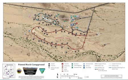
Painted Rock Petroglyph Site and Campground is a popular destination for camping, picnicking, and viewing one of the most significant petroglyph sites in the Sonoran Desert. The campground features two loop roads, the Hohokam Loop and the Patayan Loop, with 60 numbered campsites, two group sites, and a petroglyph site with day use access. An inset map in the lower left shows the location of Painted Rock Campground within Arizona.
Sixty numbered campsites are shown on the map, numbered 1 through 60. Three handicap-accessible campsites are shown with a wheelchair symbol. Two group sites are shown — Group Site A and Group Site B — located on the eastern side of the campground.
Facilities shown on the map include restrooms, an information kiosk, a picnic shelter, a pay station, a visitor registration station, interpretive signs, a camp host site, an assistant host site, trash receptacles, benches, and bike racks. The Painted Rock Petroglyph Site is shown in the northeastern portion of the campground map, with a designated day use access area. Pedestrian trails connect the campground to the petroglyph site and are shown as dotted lines on the map.
Campground roads are shown as solid black lines. There are no paved roads within the campground. Campsite access roads are shown as dashed lines. One-way roads are marked with flow-of-traffic arrows. Rocky Point Road runs along the northern edge of the campground and provides the main entry route to the campground loops.
The Butterfield Overland Stage Route historic trail is shown as a dotted line crossing through the map area.
This map was produced on Dec. 7, 2018, at a scale of 1:1,800 using the NAD 1983 coordinate system.
For questions, contact the Lower Sonoran Field Office.
No warranty is made by the Bureau of Land Management as to the accuracy, reliability, or completeness of these data for individual use or aggregate use with other data. Original data were compiled from various sources. As a result, routes shown on non-BLM land may not be accounted for and/or depicted. This information may not meet National Map Accuracy Standards. This product was developed through digital means and may be updated without notification.