
Middle Gila Canyons Area Map
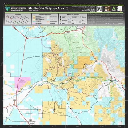
This free, downloadable georeferenced PDF map covers the Middle Gila Canyons Area in Pinal and Gila counties managed by the Bureau of Land Management (BLM) Tucson Field Office. The Middle Gila Canyons Area encompasses a rugged landscape of canyons, washes, and desert mountains along the Gila River between Florence and Superior, Arizona.
The map uses color-coding to show which agency manages each parcel of land within and surrounding the Middle Gila Canyons Area.
Trailheads, portal signs, and points of interest are shown on the map. Trailheads shown include the Cottonwood Canyon Trailhead, Florence-Kelvin Trailhead, Cochran Kelvin Trailhead, Red Mountain Trailhead, White Canyon Trailhead, and Picketpost Trailhead. Points of interest include the Boyce Thompson Arboretum, Superior Caboose Visitor Center, McFarland State Historic Park, Martinez Cabin, Martinez Gate, 15 Mile Ranch, and Reymert Townsite. A 5 Points Extremely Rough Route is also noted on the map.
Topographic contour lines are shown at 100-foot intervals, with index contours at 500-foot intervals. Named peaks and summits within and surrounding the map area include Battle Axe (3,531 ft.), Bell Butte (3,094 ft.), Big Dome (2,208 ft.), Black Hill (1,781 ft.), Cat Hills (2,257 ft.), Comet Peak (2,671 ft.), Conley Points (1,942 ft.), Copper Butte (3,192 ft.), Dozer Hill (1,863 ft.), Dromedary Peak (3,008 ft.), Government Mountain (4,196 ft.), Granite Mountain (4,042 ft.), Grayback (3,563 ft.), Haleys Mountain (4,564 ft.), Hot Tamale Peak (4,442 ft.), Mineral Mountain (3,241 ft.), North Butte (2,890 ft.), Picketpost Mountain (4,383 ft.), Picture Rocks (1,932 ft.), Poston Butte (1,732 ft.), Ripsey Hill (3,914 ft.), Scott Mountain (5,075 ft.), Sleeping Beauty Mountain (4,370 ft.), South Butte (2,743 ft.), Teapot Mountain (4,485 ft.), and Troy Mountain (4,951 ft.).
Named canyons shown on the map include Box Canyon, Cottonwood Canyon, Devils Canyon, Martinez Canyon, Telegraph Canyon, and Walnut Canyon. Named washes include Arnett Creek, Box O Wash, Cedar Creek, China Wash, Cottonwood Creek, Cottonwood Wash, Donnelly Wash, Dry Wash, Eagle Wash, Hackberry Creek, Hackberry Wash, Hot Tamale Wash, Jmi Thomas Wash, Lyons Fork, Mill Creek, Milky Wash, Mineral Creek, Oak Creek, Potters Wash, Rancho Rio Creek, Ripsey Wash, Tillmans Wash, and Zelleweger Wash. The Gila River and the Central Arizona Project canal are also shown.
Historic mines shown on the map include the Ajax Mine, Alice Mine, Calumet Mine, Columbia Mine, Copper Butte Mine, Golden Bell Mine, Hackberry Mine, Herring Mine, Martinez Mine, Monitor Mine, Myres Mine, Oklahoma Mine, Old Ripsey Mine, Silver Bell Mine, Sultana-Arizona Mine, Sunset Mine, Woodpecker Mine, and Wooley Mine. The Ray Mine is also shown in the eastern portion of the map area.
The map shows several categories of transportation routes. State and federal highways shown include US Route 60, State Route 79, State Route 177, and State Route 287. County roads are existing roads accessible by standard vehicles. Public Land Access Routes provide the main access to BLM land from local public highways or county roads — some routes across private property may not have legal public access, and users should stay on the road. National Forest Routes and Connecting Routes are shown for connectivity only and do not imply legal public access. Primitive roads are minimally maintained routes. Non-motorized trails are maintained for pedestrian, horseback, and non-motorized use. The Arizona National Scenic Trail is shown. Technical vehicle sites and a railroad are also shown.
Portal signs mark several road access points, including the Box Canyon South Portal, Cottonwood Canyon Road Portal, Mineral Mountain Road Portal, Battleaxe Portal, Tower Road Portal, Whitlow Ranch Road Portal, Cochran Road Portal, Sandman Road Portal, and Price Road Portal. A railroad trestle bridge is also shown.
This map was produced in August 2022. The map number is 3008-01-01. The coordinate system is NAD 1983 UTM Zone 12N.
For questions, contact the Tucson Field Office at 3201 E. Universal Way, Tucson, AZ 85756, by phone at 520-258-7200, or by email at [email protected].
While every effort has been made to ensure the quality of the information presented, the Bureau of Land Management (BLM) makes no warranty regarding the accuracy or completeness of this map. This map and data are representational and are to be used as intended by the BLM. Map data are compiled from various sources. This map and the data from which it was derived are not binding on the BLM and may be revised at any time. Routes depicted on non-BLM lands are displayed for information purposes only and do not grant access to non-BLM lands.
Public Land Access Routes provide the main access to BLM land from the local public highways or county roads. Some routes across private property may not have legal public access, and users should stay on the road.
National Forest Routes and Connecting Routes are shown for connectivity only and do not imply legal public access. Travel routes depicted on this map across Arizona State Trust Lands or private lands do not imply legal public access to use or cross those lands. Any public use of State Trust Lands is strictly under the jurisdiction of the Arizona State Lands Department and use of private lands requires permission of the landowner. All users must comply with State policies and regulations and private landowner rights in order to legally use or traverse non-BLM lands.