
Lake Havasu South Fish Habitat Coves Map
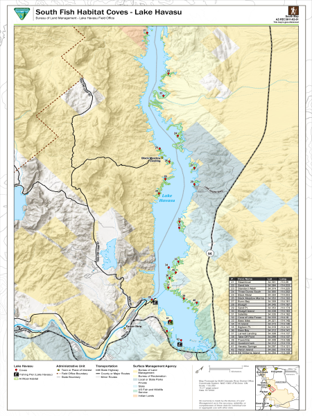
This free, downloadable georeferenced PDF map shows fish habitat coves, artificial habitat areas, and fishing piers along the southern portion of Lake Havasu in Arizona, which are managed by the Bureau of Land Management (BLM) Colorado River District Lake Havasu Field Office.
An inset map in the lower right shows the location of the map area within the broader region, including Bullhead City, Kingman, Lake Havasu City, and Parker for geographic reference.
Twenty-three numbered fish habitat coves are shown on the map with red markers. Each cove is listed in a reference table on the map with its name, latitude, and longitude.
| Number | Cove Name | Latitude | Longitude |
|---|---|---|---|
| 21 | Steamboat | 34.391 | -114.26 |
| 22 | Sand Isle | 34.384 | -114.233 |
| 23 | Standard Wash | 34.374 | -114.225 |
| 24 | Three Dunes South | 34.365 | -114.202 |
| 25 | Black Metal | 34.354 | -114.203 |
| 26 | Black Meadow Marina | 34.353 | -114.193 |
| 27 | Burro Bay | 34.359 | -114.181 |
| 28 | Bluegill | 34.345 | -114.187 |
| 29 | Sand Pt. | 34.353 | -114.174 |
| 30 | Bluegill Island | 34.338 | -114.183 |
| 31 | Satellite | 34.335 | -114.162 |
| 32 | Cove of Little Foxes | 34.333 | -114.16 |
| 33 | Bass Isles | 34.321 | -114.145 |
| 34 | Hi. Island | 34.315 | -114.148 |
| 35 | Bighorn Pt. | 34.316 | -114.141 |
| 36 | Bass Bay | 34.312 | -114.141 |
| 37 | Larned Landing | 34.308 | -114.137 |
| 38 | Take Off Point | 34.299 | -114.137 |
| 39 | Powerline | 34.309 | -114.128 |
| 40 | Questionmark | 34.312 | -114.119 |
| 41 | Havasu Springs | 34.297 | -114.121 |
| 42 | Heron Island | 34.292 | -114.118 |
| 43 | Bill Williams Island | 34.294 | -114.108 |
A fishing pier at Lake Havasu is shown with a distinct pier symbol. Artificial habitat areas are shown in green along the lake shoreline.
Towns and places of interest are shown with a circle symbol. The field office boundary is shown with a dashed dark brown line. The state boundary between Arizona and California is shown for geographic reference.
State highways are shown as solid black lines, including Arizona State Route 95 along the eastern shore of Lake Havasu. County or major routes are shown as solid gray lines, including Parker Dam Road, Trail End Camp Road, and California Highway 62. Minor routes are shown as thin gray lines.
The map also shows land management by agency for the area surrounding Lake Havasu.
Contact the Lake Havasu Field Office at 1785 Kiowa Avenue, Lake Havasu City, AZ 86403, by phone at 928-505-1200, or by email at [email protected].
This map was produced by the Colorado River District Office. The date of production is June 7, 2024. This map is the south map in a two-map series covering Lake Havasu fish habitat coves. The map number is AZ-REC3011-02-01. The scale is 1:55,000 for standard 11×17-inch page output using the NAD 1983 UTM Zone 12N coordinate system.
No warranty is made by the Bureau of Land Management as to the accuracy, reliability, or completeness of these data for individual use or aggregate use with other data.