
Ironwood Forest National Monument Map
This free, downloadable georeferenced PDF map covers Ironwood Forest National Monument northwest of Tucson, Arizona. The Ironwood Forest National Monument is managed by the Bureau of Land Management (BLM) Tucson Field Office.
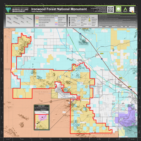
The monument boundary is shown with a solid red line. Trailheads, day use sites, group sites, and information kiosks are shown on the map. Recreation sites include the Ragged Top Trailhead, Waterman Trailhead, Waterman Group Site, and Silverbell Group Site. An inset map shows the detail of the Titan II Site and Waterman Group Site area along West Avra Valley Road. The Juan Bautista de Anza National Historic Trail is shown crossing through the monument area.
Named mountain ranges shown on the map include the Silver Bell Mountains, West Silver Bell Mountains, Waterman Mountains, Sawtooth Mountains, Roskruge Mountains, Tucson Mountains, Suizo Mountains, and Samaniego Hills. Named communities shown include Avra Valley, Marana, Picture Rocks, and Red Rock.
Topographic contour lines are shown at 100-foot intervals, with index contours at 500-foot intervals. Named peaks and summits within and surrounding the monument include Ragged Top (3,832 ft.), Amole Peak (4,393 ft.), Apache Peak (3,071 ft.), Cerro Negro (2,192 ft.), Cerro Prieto (2,684 ft.), Cocoraque Butte (2,736 ft.), Desert Peak (2,549 ft.), Dos Titos (3,173 ft.), El Cerrito de Gallinas (2,418 ft.), El Cerrito de Represso (2,359 ft.), Indian Head (2,175 ft.), Malpais Hill (2,543 ft.), Owl Head Buttes (3,005 ft.), Panther Peak (3,428 ft.), Picacho Peak (3,320 ft.), Picture Rocks (2,854 ft.), Red Hill (2,247 ft.), Safford Peak (3,530 ft.), Signal Hill (2,474 ft.), Silver Bell Peak (4,268 ft.), Solo Peak (2,936 ft.), Tator Hills (1,873 ft.), The Huerfano (2,667 ft.), Twin Peaks (2,425 ft. and 2,749 ft.), Wasson Peak (4,662 ft.), Waterman Mountains (3,028 ft.), Waterman Peak (3,773 ft.), Wildcat Peak (2,523 ft.), and Wolcott Peak (3,304 ft.).
Named washes shown on the map include Aguirre Wash, Blanco Wash, Brawley Wash, Cocio Wash, Coronado Wash, Durham Wash, El Tiro Wash, Greene Canal, Greene Wash, Guild Wash, House Wash, Los Robles Wash, Mammoth Wash, Parker Wash, Silver Reef Wash, Suizo Wash, and Tat Momoli Wash. The Santa Cruz River and the Central Arizona Project canal are also shown.
The map uses color-coding to show which agency manages each parcel of land within and surrounding the monument. County boundaries between Pima and Pinal counties are shown with a dashed gray line. Interstate 10 is shown along the eastern edge of the map with access at exits 226, 236, and 242. Mined land and a railroad are also shown for reference.
The map shows five categories of transportation routes. County roads are existing roads maintained by Pima or Pinal County and are accessible by passenger vehicle. Local roads cross some private property and may not have legal public access — routes are displayed for information purposes and do not grant access across non-BLM lands. Primitive roads are minimally maintained routes where 4WD high-clearance vehicles are recommended. Administrative routes are open to administrative vehicles and mechanized non-motorized public travel, including bicycle, pedestrian, and horseback riding. Trails are maintained for non-mechanized and non-motorized access and are accessible to pedestrians and horseback riders.
This map was produced in July 2023. The map number is 1004-01-01. The coordinate system is NAD 1983 UTM Zone 12N. Data sources include the Bureau of Land Management and other federal and state agencies.
For questions, contact the Tucson Field Office at 3201 E. Universal Way, Tucson, AZ 85756, by phone at 520-258-7200, or by email at [email protected].
While every effort has been made to ensure the quality of the information presented, the BLM makes no warranty regarding the accuracy or completeness of this map. This map and data are representational and are to be used as intended by the BLM. Map data are compiled from various sources. This map and the data from which it was derived are not binding on the BLM and may be revised at any time.
Travel routes depicted on this map across Arizona State Trust Lands or private lands do not imply legal public access to use or cross those lands. Any public use of State Trust Lands is strictly under the jurisdiction of the Arizona State Lands Department and use of private lands requires permission of the landowner. All users must comply with State policies and regulations and private landowner rights in order to legally use or traverse non-BLM lands.