
Grand Canyon-Parashant National Monument Map
This free, downloadable PDF map shows Grand Canyon-Parashant National Monument in the Arizona Strip of northwestern Arizona. This map can be printed or viewed on any computer, tablet, or phone. It is not a georeferenced map and does not display GPS location on a mobile device.
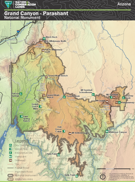
Grand Canyon-Parashant National Monument is one of the most remote national monuments in the United States, encompassing a vast plateau landscape of canyons, wilderness areas, and volcanic features north of the Grand Canyon along the Arizona-Nevada border. The monument boundary is shown with a dark outline on the map.
Three wilderness areas are shown on the map with a brown crosshatch pattern. The wilderness areas shown are the Grand Wash Cliffs Wilderness, Mount Logan Wilderness, and Paiute Wilderness. The Paiute Wilderness is further divided into Paiute Wilderness North and Paiute Wilderness South.
Day use sites, historic sites, interpretive sites, viewpoints, and trailheads are shown on the map with distinct symbols. Named recreation sites and points of interest shown include Black Rock, Grand Gulch Mine, Grand Wash Bench, Kelly Point, Mt. Dellenbaugh, Mt. Logan, Mt. Trumbull, Mt. Trumbull Schoolhouse, Nampaweep, Oak Grove Cabin, Pakoon Springs, Paiute Wilderness North, Paiute Wilderness South, Poverty Kiosk, Tassi Spring Ranch, Twin Point, Tuweep Kiosk, and Whitmore Canyon.
Paved roads are shown as solid dark lines and improved roads are shown as solid gray lines. Named roads shown on the map include Agway Road, Antelope Trail Road, Cave Road, Cottonwood Road, Craigs Ranch Road, Elbow Canyon Road, Grand Gulch Road, Grand Wash Road, Grassy Point Road, Lime Kiln Road, Mount Dellenbaugh Road, Mount Trumbull Road, Mud Mountain Road, Navajo Trail Road, Pakoon Springs Road, Pocum Wash Road, Quail Hill Road, Snap Point Road, Temple Trail Road, and Whitmore Bench Road. Interstate 15 is shown in the northwestern corner of the map near Mesquite, Nevada.
Trails are shown as dashed red lines on the map.
The Colorado River is shown along the western and southern edges of the monument, forming the boundary with Nevada and the northern boundary of Grand Canyon National Park. The Virgin River is shown in the northwestern portion of the map near Mesquite, Nevada. Lake Mead is shown in the far western edge of the map.
Grand Canyon National Park borders the monument to the south. Nevada borders the monument to the west.
This map was produced in 2015. The map number is M14-09-01.
For questions, contact the Public Lands Information Center.
No warranty is made by the BLM as to the accuracy, reliability, or completeness of these data for use or for purposes not intended by BLM.