
Skedaddle | California
Skedaddle Wilderness Study Area (WSA)
Discover the Skedaddle WSA and Explore Diverse Landscapes and Unique Geology in Northeastern California and Northwestern Nevada! For a Map and Brochure of the BLM Eagle Lake Field Office WSA's click here: Brochure
The Skedaddle Wilderness Study Area (WSA) is a remarkable natural region located primarily in Lassen County, California (99.5%), with a small section extending into Washoe County, Nevada (0.5%). Spanning roughly 10 by 12 miles, the WSA encompasses 62,010 acres managed by the Bureau of Land Management (BLM), along with 1,179 acres of private land distributed across seven parcels, each ranging from 40 to 640 acres.
Download the Eagle Lake Field Office Skedaddle WSA Map here: Map
Hunting & OHV Use
Hunting is a traditional and permitted recreational activity within the Skedaddle Wilderness Study Area (WSA). The Bureau of Land Management manages WSAs to preserve wilderness characteristics while allowing uses that do not impair the area’s suitability for future wilderness designation.
General Regulations
- Hunting is allowed in accordance with California and Nevada state laws, seasons, licensing requirements, and zone designations.
- Firearms and archery equipment are permitted; hunters must adhere to federal and state shooting safety restrictions, including 36 CFR, which prohibits shooting within 150 yards of residences, buildings, campsites, or developed recreation sites.
Motorized and Mechanized Access
- Motorized and mechanized travel is limited to existing designated routes. Cross‑country travel is prohibited.
- Vehicles, including ATVs/UTVs, may not travel off designated open routes to retrieve game.
Resource Protection
- Hunters must avoid disturbing cultural sites, wildlife habitat, and riparian areas.
- Do not construct blinds, platforms, or other structures. Permanent installations are not allowed within WSAs.
Scenic Landscapes
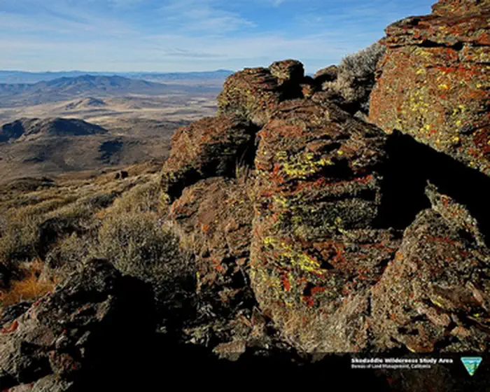
Situated on the northwestern edge of the arid Great Basin, the area features dramatic eroded volcanic mountains and expansive desert valleys—remnants of ancient lake beds. The Skedaddle and Amedee Mountains, found at the heart of the WSA, dominate the landscape, rising from seasonally dry lake beds and gentle hills. Elevations range from 4,200 feet to Hot Springs Peak, which towers at 7,680 feet atop Skedaddle Mountain.
Geological Wonders
At the center of the WSA lies an eroded volcanic caldera with rugged cliffs, winding canyons, striking peaks, and upland basins. The higher slopes of the Skedaddle Mountains are dotted with groves of aspen and large berry shrubs, especially on northern exposures. Deep canyons support diverse riparian vegetation, including willows, wild roses, and berry shrubs, while upland basins host small grassy meadows. Sagebrush and bunch grass cover much of the landscape, creating a quintessential Great Basin environment.
Distinctive Features
The northern and eastern boundaries of the WSA are characterized by open sagebrush flats that gently transition into long toe slopes approaching Skedaddle Mountain. On the southern and western edges, toe slopes are blanketed with shrubs and grasses atop alluvial and gravel benches—the visible remains of Pleistocene Lake Lahontan’s ancient shorelines. These slopes rise into the steep, rocky terrain of the Amedee Mountains, which are defined by numerous canyons and ridges to the south and bordered by the nearly vertical, crumbly volcanic cliffs known as Wendell Cliffs to the west.
Whether you’re seeking striking geological formations, diverse plant life, or stunning vistas, the Skedaddle Wilderness Study Area offers an unforgettable experience for outdoor enthusiasts and nature lovers alike.
Visit other WSA's in Lassen County:
For additional information about BLM CA Wilderness Study Area visit the BLM CA Website
Photos
Contact Us

Fees
Camping and day use are free. For fee and permit information, contact the BLM Eagle Lake Field Office.