
Sacramento River Bend Area | California
Overview
The Sacramento River Bend Area is a valuable historic and natural resource that presents many recreational and educational opportunities. From the lush riparian areas surrounding the Sacramento River and it's tributaries to the expanse of the rolling hills of blue oak savannah, the Sacramento River Bend Area offers diverse habitat for bald eagles, osprey, migratory and song birds, deer, and salmon. The area also offers numerous recreation opportunities for hunting, camping, hiking, boating, picnicking, and wildlife viewing.
Trails
Most attractions along the river can be reached by foot, mountain bike or horseback.
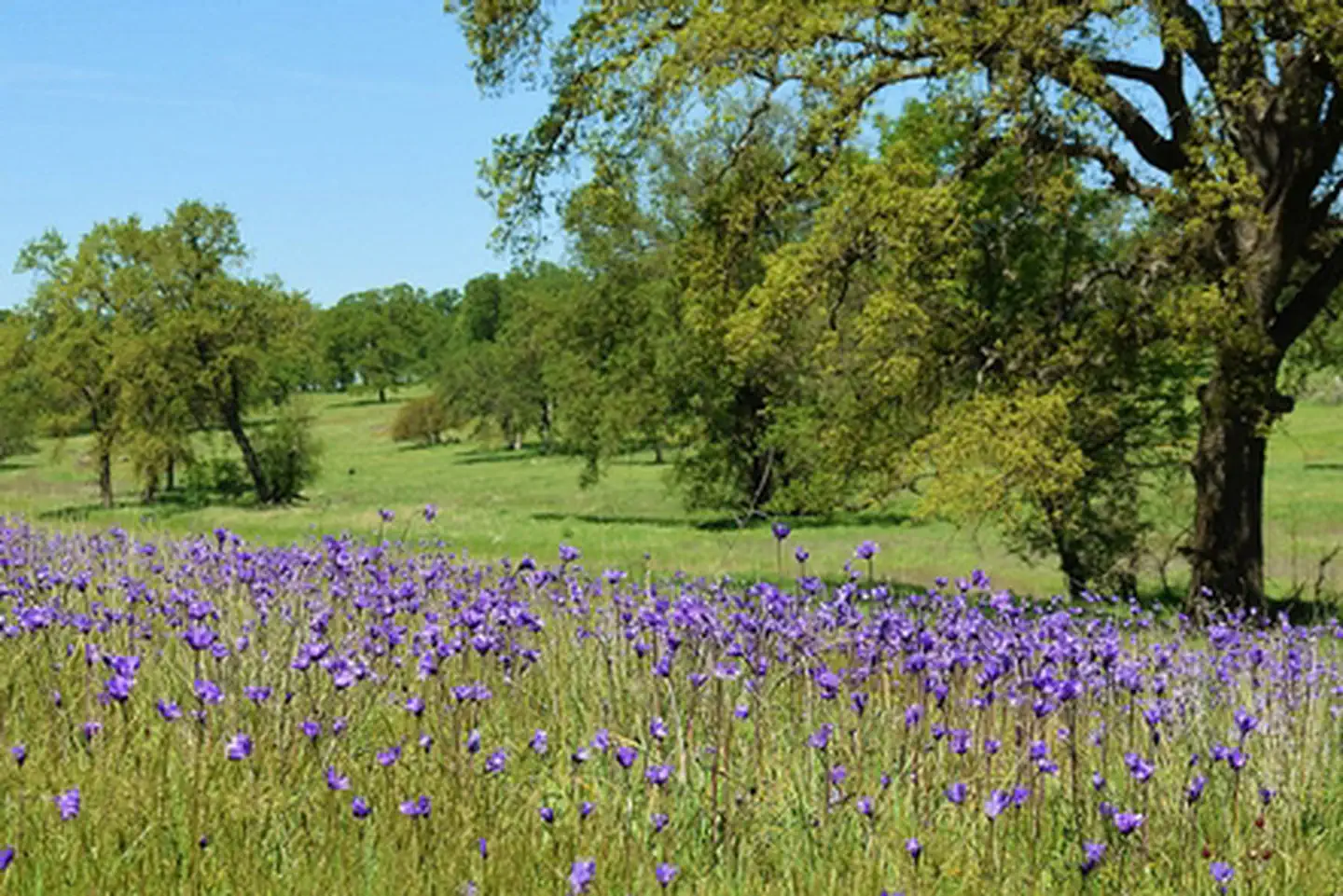
Wildflowers
This area offers amazing wildflowers viewing in the spring. The rolling hills of this oak woodland are carpeted with purple and yellow in all directions.
Boating Access
The Sacramento River (from Balls Ferry to Red Bluff) is served by a variety of developed boat ramps and primitive river access sites. Public boat ramps are available at Balls Ferry, Bend Bridge Park, and Lake Red Bluff Recreation Area. Jelly's Ferry, Barge Hole, and Perry Riffle (walk in only) offer primitive launch sites. The boat ramp at Reading Island can be used by small watercraft, but is usually overgrown with vegetation during the summer months making it challenging for any watercraft. Please see the Sacramento River Bend Area map for specific locations and directions.
Paynes Creek Wetlands
Concerns have increased in recent years over population declines of migratory bird species that breed in North America and winter south of the United States - Neotropical Migratory Birds. The BLM recognizes this problem and has created the Payne's Creek Wetlands with the help of partners like California Fish and Game, Bureau of Reclamation, California Wildlife Conservation Board, and Ducks Unlimited in an effort to enhance populations of these birds and other species. The BLM manages this wetland area, located along the Pacific Flyway, to protect and enhance the existing riparian habitat and wildlife communities, as well as provide for recreational use, cultural and natural interpretation, and educational opportunities.
Download the Birds of Bend Brochure to discover all the birds that frequent the area.
Camping
Although there are no developed BLM campgrounds in this area, camping is allowed on most BLM lands for up to 14 days per calendar year. Day-use sites such as the Jelly's Ferry site, the mouth of Inks Creek, and the Bass Pond parking areas are closed to camping. Group camping is available at the Reading Island Group Campground, under a special use permit issued by the BLM. Massacre Flat is a popular primitive campsite for boaters. The state managed Battle Creek and Cottonwood Creek Wildlife Areas are closed to camping. There is no garbage collection in most of the area so if you PACK IT IN please PACK IT OUT.
Hunting
Most BLM lands are open to hunting under California Department of Fish and Game regulations. Some sites such as Reading Island and the state managed Battle Creek Wildlife Area are closed to hunting and shooting. Be courteous to private property owners adjacent to public land. Remember, it is against State law to discharge a weapon within 150 yards of a dwelling or outbuilding. Target shooting is prohibited with the exception of one designated target shooting area along Spring Branch Road. Please remove all shells and debris to keep your public lands clean and safe.
Safety Concerns
• The Sacramento River water is cold (45°-50°) year-round and is deceptively swift and powerful.
• Always wear an approved floatation device when on the river.
• The Yana Trail fords Inks Creek and is impassible at times of wet weather. Contact the BLM Redding Field Office prior to a wet weather hike on the Yana Trail.
• Rattlesnakes are a common sight on warm days. Watch your step.
• Summer temperatures in this area can exceed 100°F and there is no potable water available in the area, so bring plenty of drinking water.
Photos
Accessibility Description (ABA/ADA)
View images of accessibility features in a new window.
Bass Pond
This day-use site has a large gravel parking lot with 1 designated accessible parking space with an access aisle in the northwest corner of the lot, next to the accessible single vault toilet. There is no running water and cell service is spotty at the site.
From the parking area, visitors can take the hardened, compacted gravel path north to a paved spur leading to the wooden observation deck at the pond. The observation deck has wooden guard rails around it.
The main gravel path continues on past the spur part way around the pond. There is 1 bench without arms on this accessible path.
Picnic tables that can accommodate wheelchair users can be found in the grassy area with somewhat uneven ground to the east of this path and southeast of the deck on compacted dirt.
Visitors can drive farther into the Sacramento River Bend Area, to the northeast of Bass Pond on Bend Ferry Road, which has pull-offs for bird-watching near the wetlands. The same road provides access to Jellys Ferry Day-Use Site and to trailheads where visitors can park to view wildlife and enjoy the natural surroundings. The trails themselves were not designed with accessibility in mind.
All the sites listed below have a kiosk with a trail map, regulations, and safety information. There is no potable water at any of the sites, and cell service is spotty throughout the area.
Jellys Ferry Day-Use Site
To reach this site from Bass Pond, drive back out Bend Ferry Road the way you came in. Then turn right on Jellys Ferry Road and drive about 10 minutes.
The site has a packed-dirt parking area with 1 designated, paved accessible parking spot next to a single vault accessible toilet. The parking area connects with a gravel loop that leads through the site.
There are 2 picnic shelters covering tables on concrete pads. These tables have inset legs that allow wheelchair users to pull up to the ends. At each shelter, a pedestal grill sits on dirt just beyond the concrete.
The site serves as a trailhead to access the Yana Trail and other trails that were not designed with accessibility in mind.
Perry Riffle Trailhead
This trailhead has a gravel parking lot next to an accessible single vault toilet. There are 2 picnic tables with inset legs allowing wheelchair users to pull up to the ends; one sits on a paved surface and the other is on gravel. Trails in this area were not designed with accessibility in mind.
Coyote Pond Trailhead
This trailhead has a gravel parking lot next to an accessible single vault toilet. Although it doesn’t have a parking space designated for accessibility, the entire lot should be suitable for people with mobility devices. Erosion may cause a lip to form between the entrance to the toilet and the surface of the parking lot.
A gravel path 250 feet long leads from the parking area to a pier with wooden railings that provides views of the pond. The transition from the path to the pier may be challenging for some visitors with mobility limitations.
A picnic table with inset legs sits on gravel under a tree near the pier. One end of the table is near a grassy area, so wheelchair users may need to pull up to the other end.
Trails in this area were not designed with accessibility in mind.
Note: Descriptions and photos uploaded June 2025. Please note that actual on-the-ground conditions may vary due to natural events (e.g., weather, wildfires, erosion), normal wear and tear, or site improvements.
Contact Us


