
Fish & Owl Loop Trail | Utah
Fish and Owl Creeks both cut diagonally across the eastern edge of Cedar
Mesa, coming together several miles before they enter Comb Wash. They are
both deep canyons, quite narrow, with an abundance of scenic beauty. Erosion from
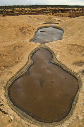
Fish and Owl Creeks have created canyons that differ from the other canyon systems on Cedar Mesa by their depth, the narrowness of the canyons, and their pools of water in the spring to fall months. The canyon walls average 500 feet high, with the width varying from several hundred feet to very narrow at the upper reaches of Fish creek.
Many of the pools in these canyons have extensive hanging gardens, offering a wide variety of vegetation. The rare Kachina daisy (Erigeron kachinensis) can be found at one of these springs. The vegetation varies from sage flats in the lower ends of the canyons to cottonwood trees and pine stands on the wider benches in the upper forks. Nevill’s Arch is an impressive, prominent feature in Owl Creek, jutting out into the canyon from high on a "fin” of Cedar Mesa Sandstone. There is another arch in Fish Creek, but it is hardly visible unless you are directly below it.
Flickr Album:
Contact Us

Addresses
365 North Main
Monticello
Utah
84535
Directions
The road access to the trailhead is 1 mile south of the Kane Gulch Ranger Station on State Route 261. Turn east and drive approximately 5 miles on a dirt road to an old drill hole which is the parking area. There is a bulletin board, register box, fee station, and pit toilets for day hikers at the trailhead. This road is passable to passenger vehicles (two-wheel drive) during good weather; however rain or snow can make it impassable even to four-wheel drive vehicles. Access to Lower Fish is 9.1 miles south on Comb Wash Road from highway 95 or 9.2 miles north on Comb Wash Road from highway 163, turn on (CR D2294)