
McInnis Canyons National Conservation Area
Located in the high desert canyon country of western Colorado and eastern Utah, McInnis Canyons National Conservation Area consists of approximately 123,739 acres of BLM-administered land near Grand Junction, Colorado. Originally known as Colorado Canyons National Conservation Area, the NCA was established by Public Law 106–353 on October 24, 2000, and was renamed in honor of Representative Scott McInnis by Public Law 108–400 on January 1, 2005.
Among its unique natural resources are the more than 75,000 acres of the Black Ridge Canyons Wilderness, which includes the second-largest concentration of natural arches in North America. Internationally important fossils have been uncovered during more than a century of excavation. Pictograph and petroglyph sites abound, and the Old Spanish Trail, once referred to as the “longest, crookedest, most arduous mule route in the history of America,” runs through the NCA. Today, the NCA is a recreation destination, drawing visitors to the world-class mountain biking on Mack Ridge and along the 142-mile Kokopelli trail, which extends to Moab, Utah. Twenty-five miles of the Colorado River wind their way through the NCA, attracting boaters who value straightforward floating through spectacular multi-hued sandstone canyons.
The NCA benefits from the attention of a vibrant network of people, from historic and current ranching families to the active Friends group working to protect and support this special place. Traditional land uses, such as grazing, continue, guided by management to protect the values for which the NCA was established.
- Know Before You Go
-
The McInnis Canyons National Conservation Area was designated with broad local, regional and national support by an act of Congress in 2000. Traditional uses such as livestock grazing, hunting and fishing are important uses in the NCA and are specifically protected by the designating legislation and Resource Management Plan.
You may encounter livestock when visiting the NCA. Please close gates behind you and avoid interfering with livestock operations.
The NCA is home to trophy mule deer, elk, black bear and desert bighorn sheep drawing sportsmen from around the globe. Big game, upland bird, and migratory waterfowl hunting contributes millions to the regional economy and is a valued activity in the NCA.
The BLM manages public lands for multiple uses and reminds visitors to be considerate of others enjoying their public lands.
The NCA's terrain ranges from dry, high plains desert to deep canyons along the Colorado River. The BLM recommends you let someone know your plans before visiting and to bring along plenty of water due to limited water availability. You will encounter picturesque views, fascinating historical artifacts, as well as unique plants and geologic features. Leave fossils and artifacts as you find them. Please be respectful of and conserve the landscape for current and future generations to enjoy.
- Map Links
-
BLM Clorado Interactive Map
McInnis Canyons NCA Travel System Geo-Referenced Map
- Black Ridge Canyons Wilderness
-
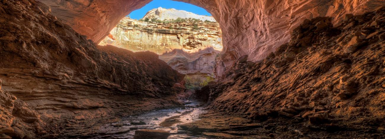
The Black Ridge Canyons Wilderness features distinctive spires and arches, massive alcoves, beautiful desert patina, and seven major red rock canyon systems. The wilderness is located within the McInnis Canyons National Conservation Area. The area is home to deer, mountain lion, and desert bighorn sheep, as well as golden and bald eagles.
Visitors can enjoy hiking, horseback riding, hunting, backpacking, and primitive camping in the wilderness; as well as rafting, canoeing, and kayaking on the Colorado River.
Elevation Range: 4,300 to 7,130 feet
- McInnis Canyons Recreation Areas
-
McInnis Canyons Recreation Zones
Rabbit's Ear/Wildhorse Mesa/McDonald Creek
- Rabbit's Ear Trail is located in Rabbit Valley within the McInnis Canyons National Conservation Area. This 5.6-mile loop climbs 700 feet to an impressive vista of the Colorado River and the Grand Mesa to the LaSal Mountains in Utah. This trail is open to hiking only.
- Wild Horse Mesa is an equestrian and hiking trail located in Rabbit Valley within McInnis Canyons National Conservation Area.
- McDonald Creek - Hike along a stream bed for several miles to the Colorado River in search of rock art sites among outstanding scenery. Please be considerate of this fragile desert canyon - All the rock art can be seen without leaving the trail. Binoculars are a very good way to see the rock art details. Please walk only in the streambed to help preserve the natural beauty and your sense of discovery of this area. The McDonald Creek Cultural Area is closed to camping and campfires and the trail is open to foot traffic only.
Rabbit Valley Motorized Area
In Rabbit Valley, located in the McInnis Canyons National Conservation Area, the primary activities are motorcycle and ATV riding, and camping, while there are also opportunities for mountain biking. Trails are marked with permitted activities. There are three campgrounds: Jouflas, Castle Rocks, and Knowles Overlook. Dispersed camping is allowed ONLY in designated sites, which are numbered and signed. A fire-pan and a portable toilet are required for dispersed camping. For a map and more information on motorized recreation in Rabbit Valley, visit Colorado Canyons Association.Paleontology Trails
- Rabbit Valley Trail Through Time - View the fossils of 140-million-year-old dinosaurs at a working fossil quarry with a 1.5 mile (loop) interpretive trail. There is also an interpretive kiosk that describes the numerous dinosaurs that have come from Rabbit Valley. This is a designated Area of Critical Environmental Concern.
- Fruita Paleo Area - Located in the McInnis Canyons National Conservation Area (NCA), this trail is a 1/2 mile hike that takes about an hour allowing time to read the interpretive exhibits.Twenty vivid, artistic renderings help to interpret the area's geologic and paleontological history. The area is only open to foot travel. This area also provides access to the historic Skinner Cabin. Please help protect your heritage! Do not remove or alter any materials. It is illegal to remove any resources from the National Conservation Area.
- Dinosaur Hill Trailhead - A mildly strenuous hike to the overlook provides panoramic views of the Grand Valley and the Colorado River. There are picnic sites and a large parking area for RVs. There are several interpretive signs along the trail about the dinosaur fossils that have been discovered here. The giant plant eating dinosaur, known as the Brontosaurus, was recovered here in 1901. This was one of the most complete specimens found to date. Learn how this dinosaur was recovered. View the quarry site and bone reproductions. Most of this one mile trail has been designed to include opportunities for hikers with visual impairments. There are tactile signs and a guide system.
Fruita Front Country: Hiking and Horseback Trails
- Pollock Bench Trailhead - The Pollock Bench Trailhead offers exceptional hiking and horseback riding opportunities in a landscape of colorful intricate cliffs and deep canyons that tell a story shaped by shallow seas, a meandering river systems, and ongoing uplift and erosion. There are many trail options and distances to choose from. The majority of trails out of Pollock Bench Trailhead access the Black Ridge Canyons Wilderness.
- Flume/Devils Canyon -Devil's Canyon Trailhead offers exceptional hiking and horseback riding opportunities in a landscape of colorful intricate cliffs and deep canyons that tell a story shaped by shallow seas, a meandering river systems, and ongoing uplift and erosion. There are many trail options and distances to choose from.
The National Conservation Area serves as an outdoor museum of the people and other life that came before us. Please leave what you find and help conserve your heritage! Paleontological (dinosaur fossils) and cultural sites help us understand our past. Enjoy rock art but please don't touch: oils from your hands cause deterioration. Please stay on designated trails, and remember that it is illegal to remove any resources from the National Conservation Area.
Devils, Flume, and Pollock Bench Trail System Map
McInnis Canyons NCA Travel MapKokopelli/Mack Ridge Mountain Bike Trails
Mack Ridge/Kokopelli Trails provides outstanding single-track mountain biking opportunities. Trails range in difficulty and skill level. Rustler's Loop, for example, is designed as a learning loop where riders can hone their skills, and educational signs at various features offer tips to those new to mountain biking. The area provides excellent views of the Colorado River and beyond. It is close to the City of Fruita.Colorado River Corridor: Ruby-Horsethief section
The Ruby-Horsethief section of the Colorado River, from Loma, Colorado, to Westwater, Utah, is a 25-mile stretch of mostly flat-water with sections of Class I and II rapids. This section of the Colorado runs through beautiful red rock canyons and has many day hike opportunities offering both solitude and exploration. The Black Rocks section is composed of rock known as Vishnu schist, which dates back about 1.7 billion years. This same rock, which geologists refer to as "an unconformity",is exposed in certain sections of the Grand Canyon.
There is an abundance of wildlife in the area including great blue herons, bald eagles, peregrine falcons, mule deer, and desert bighorn sheep. Please note that humans are prohibited from approaching within a 0.5 mile of eagle nests or harassing the birds in any way. Look up in old cottonwoods trees and you are likely to spot the nests and eagles.
Motorized use is allowed in Ruby Canyon. Visitors can expect to see motorized and non-motorized craft.
Due to limited camping in this 25-mile stretch of the Colorado, overnight camping permits are required year-round and must be reserved in advance (no permit is required for day use). Permits are available at recreation.gov 60 days in advance of your launch. April 1 to October 31 is considered boating season: during this time campsites are reserved for boaters only, and there is a fee for both the camping permit and reservation (children 16 years old and under camp for free year-round). From November 1 to March 31, a free overnight camping permit is required and a fee is charged for reservation only. The maximum group size is 25 including adults, children, and dogs (two dogs per group). Please note, dogs are considered part of your permit's group total and fees are assessed for dogs just as they are for people.
Ruby Horsethief Canyons - Colorado Campsites Map
Blackridge Canyons Wilderness
This Wilderness area provides outstanding opportunities for solitude and primitive recreation. Geologic features in this area include arches, spires, windows, giant alcoves and desert patina. Between these canyons are pinon-juniper covered mesas which slope downward to the Colorado River.
- Rattlesnake Arches - A short section connecting the top of the mesa to the bench below the arches is rocky and steep and requires extra caution - it is not recommended. From the trailhead travel 0.5 miles to an intersection. To the left takes you to an area where you can view the arches from above. To the right takes you to the Lower Arches Trail, which is 5 miles round trip (out and back). In 0.2 miles the trail splits: the right fork goes to Pollock Bench Trailhead, stay to the left for the Arches trail. Camping is NOT permitted within 1/4 mile of the Rattlesnake Arches Trail and along the access road to the trailhead.
- Mee Canyon: The trail into Mee Canyon is primitive and only marked with rock cairns. The route steeply descends sandstone layers with exposed cliffs. Camping is NOT permitted at the Mee Canyon Alcove.
Blackridge Canyons Wilderness Map
Leave No Trace principles:
- Old Spanish National Historic Trail
-
The Old Spanish National Historic Trail recognizes the land route traveled by traders from 19th-century Mexico - today's New Mexico - and California. From 1829 to 1848, this trail was the shortest-known route from Santa Fe to Los Angeles, through red-rock mesas, below snow-capped peaks, and fording untamed rivers, following a loose network of Native American footpaths across the Colorado Plateau and Mojave Desert.
The Old Spanish National Historic Trail is composed of three main routes: the Main Route, the Armijo Route, and the North Branch. Use would depend on peril, weather, or simple opportunistic stops.
Mules were the highest-valued pack animals, as they had incredible strength and endurance, fared better than horses where water was scarce and forage poor, and recovered more rapidly after periods of hardship.