
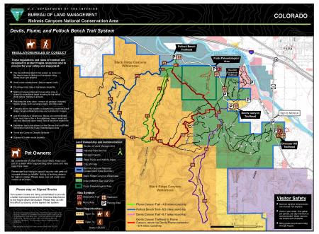
McInnis Canyons National Conservation Area Devils-Flume-Pollock Bench Trail System Map
The 122,300-acre McInnis Canyons National Conservation Area (MCNCA), located west of Grand Junction, Colorado, is a collage of natural wonders featuring rugged sandstone canyons, natural arches, spires, and alcoves carved into the Colorado Plateau, through which runs a 24-mile stretch of the Colorado River. Included in the MCNCA are 75,550 acres of wilderness designated as the Black Ridge Canyons Wilderness (BRCW) with 5,200 acres extending into eastern Utah at the MCNCA’s western boundary.
The Devils-Flume-Pollock Bench trail system is within the MCNCA front country recreation zone, which is managed for foot and Horse travel. This trail system affords the visitor the opportunity to explore the red rock canyons of the Colorado Plateau within a short distance of the city of Fruita, Colorado. All trailheads are easily accessible from maintained roads, and the trails provide a range of experiences from easy walking to strenuous hikes in a wilderness setting.